
Summary
The ATSB is investigating a collision with terrain involving a Robinson R44 II, VH-TCF, 46 km north‑east of Tenterfield Airport, New South Wales.
During a private flight from the Gold Coast, Queensland, to Mudgee, New South Wales, the helicopter collided with terrain and a post-impact fire ensued. The pilot, who was the sole occupant, sustained fatal injuries. An ATSB investigation team was deployed to the accident site.
A preliminary report, which detailed factual information established during the evidence collection phase, was released on 30 April 2026 - see below.
The final report has been drafted and is undergoing internal review to ensure the report adequately and accurately reflects the evidence collected, analysis, and agreed findings.
The final report will be released at the conclusion of the investigation. Should a critical safety issue be identified during the course of the investigation, the ATSB will immediately notify relevant parties, so that appropriate safety action can be taken.
Last updated:
Preliminary report
Report release date: 30/04/2026
| This preliminary report details factual information established in the investigation’s early evidence collection phase, and has been prepared to provide timely information to the industry and public. Preliminary reports contain no analysis or findings, which will be detailed in the investigation’s final report. The information contained in this preliminary report is released in accordance with section 25 of the Transport Safety Investigation Act 2003. |
The occurrence
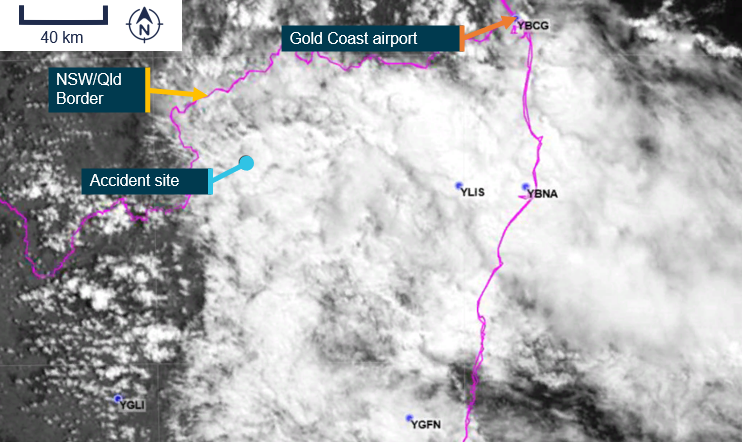
On 13 March 2026, the pilot of a Robinson R44 II helicopter, registered VH-TCF, planned to conduct a private flight from Gold Coast, Queensland, to Mudgee, New South Wales (NSW), with an intermediate stop at Armidale, NSW, to refuel (Figure 1).
Figure 1: Map showing accident site and key locations
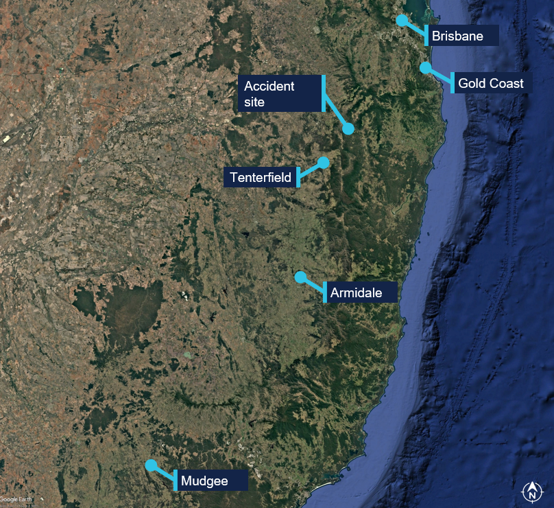
Source: Google Earth, annotated by the ATSB
At about 0834 Eastern Standard Time (EST),[1] the helicopter departed from a private helipad on the Gold Coast. The pilot was the sole occupant of the helicopter.
NSW Police advised that an automated emergency message associated with activation of the pilot’s iPhone crash alarm was received at 1046 Eastern Daylight-saving Time (EDT),[2] about an hour and a quarter after the aircraft departed. In response, a formal search was commenced by NSW Police.
The wreckage was located at 1113 EDT on 14 March 2026 in dense bushland near Paddy’s Flat, 46 km north-east of Tenterfield, NSW. The helicopter was destroyed and the pilot sustained fatal injuries.
Context
Pilot information
The pilot held a Private Pilot Licence (Helicopter) and a single‑engine helicopter class rating. The pilot also held a class 2 aviation medical certificate valid to 6 September 2026 with the following limitations:
Must use [continuous positive airway pressure] CPAP in sleep period prior to exercising privileges of medical certificate.
Reading correction to be available whilst exercising the privileges of this licence.
Records obtained from the CPAP provider showed that the pilot was regularly using the CPAP machine and that sleep apnoea was controlled.
As of 7 March 2026, the pilot’s logbook showed they had accrued 1,264.6 hours total flight time.
Aircraft information
VH-TCF was a Robinson R44 II helicopter, manufactured in the United States in 2007 as serial number 11912 and first registered in Australia in 2007. The helicopter was powered by a Textron Lycoming IO-540-AE1A5 engine. VH-TCF was being maintained in accordance with the Robinson R44 maintenance manual and the Lycoming IO-540 engine manual. According to the maintenance release, on the morning of 13 March 2026, the helicopter had a total time in service of 2,104.7 hours. There were no defects recorded.
Site and wreckage information
The accident site was located about 46 km north-east of Tenterfield Airport in a densely vegetated area to the west of Cataract National Park. It was situated on the southern side of a steep slope, at an elevation of about 870 m (2,850 ft).
The wreckage trail was approximately 12 m long in a westerly direction, across and down the slope as shown in Figure 2. It consisted of an initial impact point, followed by a trail of debris that led to the fuselage, engine and main rotors, much of which were consumed by a post-impact fire. The aft section of the tail cone assembly had separated from the fuselage and was located approximately 20 m from the fuselage across the slope.
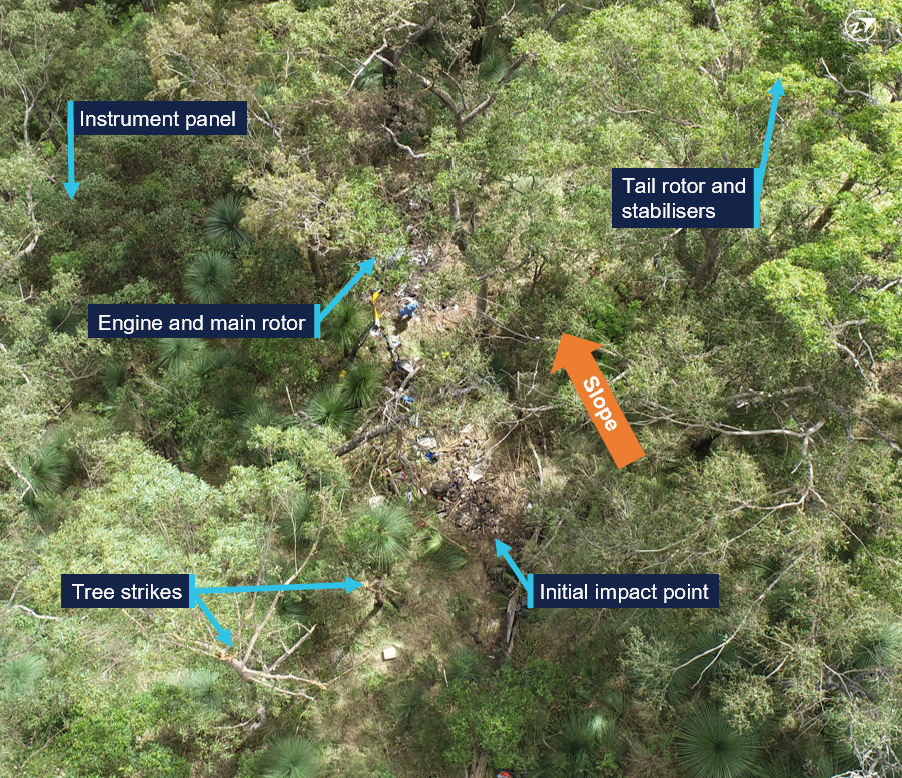
Source: ATSB
Significant damage was evident on 2 trees located near the initial impact point, indicating the helicopter had collided with trees in a near vertical descent. A bag found in the tree canopy, and various other parts from the helicopter, were located around 20 m up the slope from the initial impact site.
The instrument panel and other debris were found further down the slope away from the fuselage location. A fuel jerry can, which had been filled at the helicopter’s departure location, was found onsite. The contents were tested for presence of water, which returned a negative result.
Recorded data
Although the pilot was reportedly using the Oz Runways electronic flight bag software, no track data was transmitted to the service provider.
VH-TCF was identified on WebTrak[3] around Gold Coast Airport. It showed that the helicopter tracked roughly south-west before crossing the NSW border at 0854. This service then stopped recording the helicopter’s position (Figure 3).
Figure 3: Aircraft track from departure to the NSW border
Source: Airservices Australia WebTrak
National aeronautical information processing system (NAIPS) records showed that weather information was accessed by the pilot’s account at 0740 and 0745 on 13 March 2026. The requirements of the Aeronautical Information Publication (AIP) ENR 1.10 Flight Planning stated that a pilot must obtain current weather reports and forecasts for the route to be flown, then plan the flight having regard to that information.
Weather information
Forecasts
The Bureau of Meteorology graphical area forecast (GAF),[4] issued at 0809 EST on 13 March 2026 for the area encompassing the flight path south of Gold Coast to the accident site (Figure 4), included:
- visibility greater than 10 km with broken[5] stratus with bases at 1,500 ft and tops at 2,000 ft and broken stratocumulus with bases at 2,000 ft tops to 9,000 ft
- visibility 4,000 m in isolated[6] showers of rain with broken stratus with bases at 1,000 ft and tops at 2,000 ft, and broken cumulus/stratocumulus with bases at 2,000 ft and tops to 9,000 ft
- visibility 3,000 m in isolated drizzle with broken stratus with bases at 800 ft and tops at 2,000 ft, and overcast stratocumulus with bases at 2,000 ft and tops to 9,000 ft
- in a small coastal area just south of Gold Coast, isolated thunderstorms and rain were forecast, reducing visibility to 2,000 m with associated cumulonimbus with bases at 2,000 ft and tops above 10,000 ft, broken stratus with bases at 500 ft and tops at 2,000 ft, and broken cumulus/stratocumulus with bases at 2,000 ft and tops above 10,000 ft.
Figure 4: Geographical area forecast and additional weather stations
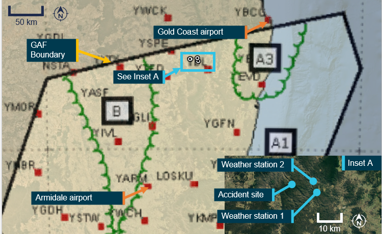
Source: Bureau of Meteorology and Google Earth, annotated by the ATSB
The previous GAF issued at 0226 on the morning of 13 March contained the same information without the forecast small area of thunderstorms. An AIRMET[7] valid from 0624 to 1024, was also issued for isolated thunderstorms in that area.
High resolution visible satellite imagery shows cloud extending inland to the NSW/Queensland border, including at the accident site (Figure 5).
Figure 5: Satellite cloud imagery at 1000 EST (14 minutes after the accident)
Source: Satellite image processed by the Bureau of Meteorology from the geostationary meteorological satellite Himawari-9, operated by the Japan Meteorological Agency, annotated by the ATSB
The aerodrome forecast (TAF)[8] for the pilot’s first intended stop at Armidale Airport, NSW, issued at 0422 EDT and valid 0600–1900 on 13 March included:
- wind from 080° at 8 kt
- visibility greater than 10 km
- cloud broken at 400 ft (TAF cloud heights above aerodrome elevation).
During the period 0900–1100:
- wind from 100°at 12 kt
- visibility greater than 10 km
- light showers of rain
- scattered cloud at 3,000 ft
- temperature 16°C at 0600 and 19°C at 0900
- QNH 1,016 hPa at 0600 and 1,019 hPa at 0900.
Weather stations
The ATSB also obtained weather data from 2 Weather Underground[9] stations close to the accident site (inset Figure 2):
Site 1: 12.64 km 106° from the accident site at an elevation of about 530 m (Table 1)
Site 2: 10.67 km 084° from the accident site at an elevation of about 200 m (Table 2).
The ultraviolet (UV) index is a simple way of describing the level of UV radiation and can be affected by the amount of cloud cover. According to the Bureau of Meteorology, ‘thick unbroken clouds and rainfall can reduce UV, as thick clouds reflect and absorb more UV that thin cloud cover.’ The UV Index has 5 categories:
- low (1–2)
- moderate (3–5)
- high (6–7)
- very high (8–10)
- extreme (11 and above).
The weather stations also measured solar irradiance, which is the power of electromagnetic radiation received from the sun, measured in watts per square metre. According to the National Environmental Satellite, Data and Information Service:[10]
When sunlight hits low clouds, a lot of that light – and heat – is reflected back into space. When sunlight hits clouds that are high in the atmosphere, those clouds reflect less sunlight energy. However, these high clouds also trap more heat.
The UV and solar irradiance[11] values from 13 March indicated that there was substantial cloud coverage at both locations on 13 March between 1004–1104 (Table 1 and Table 2). By comparison, on 15 March 2026, when the ATSB attended the accident site and observed a clear day, at 1119, the solar irradiance was recorded at 923 W/m 2 and the UV index was 9.
Table 1: Five-minute weather data, site 1
| Local time (EDT) | Temp (°C) | Dew point (°C) | Hum. % | Wind dir. | Wind (kt) | Gust (kt) | Rain mm | Rain mm/hr | UV | Solar (W/m2) |
| 1004 | 20.8 | 20.6 | 99 | ENE | 4.8 | 5.6 | 0 | 0 | 1 | 95.5 |
| 1009 | 20.9 | 20.7 | 99 | E | 3.1 | 4.5 | 0 | 0 | 1 | 94.4 |
| 1014 | 20.9 | 20.7 | 99 | ESE | 4.3 | 5.7 | 0 | 0 | 1 | 113.1 |
| 1018 | 20.9 | 20.7 | 99 | E | 3.5 | 4.8 | 0 | 0 | 1 | 136 |
| 1024 | 21.1 | 20.8 | 99 | ESE | 4.4 | 5.6 | 0 | 0 | 1 | 170 |
| 1029 | 21.1 | 20.8 | 99 | ESE | 3.9 | 5.0 | 0 | 0 | 1 | 131.6 |
| 1034 | 21.1 | 20.9 | 99 | E | 4.1 | 5.1 | 0 | 0 | 1 | 123.9 |
| 1039 | 21.1 | 20.9 | 99 | E | 4.3 | 4.9 | 0 | 0 | 1 | 121 |
| 1044 | 21.1 | 20.8 | 99 | ESE | 5.3 | 6.3 | 0 | 0 | 1 | 182.3 |
| 1049 | 21.1 | 20.8 | 99 | ENE | 3.0 | 4.6 | 0.05 | 1.27 | 1 | 94.3 |
| 1054 | 20.8 | 20.6 | 99 | E | 4.8 | 6.6 | 0.1 | 2.54 | 1 | 127.8 |
| 1059 | 20.8 | 20.6 | 99 | ESE | 3.3 | 5.0 | 0.1 | 2.54 | 1 | 102 |
| 1104 | 20.5 | 20.3 | 99 | E | 4.9 | 7.9 | 0.05 | 1.27 | 1 | 100.5 |
Table 2: Five-minute weather data, site 2
| Local time (EDT | Temp (°C) | Dew point (°C) | Hum. % | Wind dir. | Wind (kt) | Gust (kt) | Rain mm | Rain mm/hr | UV | Solar (W/m2) |
| 1004 | 24.0 | 20.9 | 83 | SSE | 2.5 | 3.0 | 0 | 0 | 1 | 95.5 |
| 1009 | 23.8 | 20.9 | 84 | WSW | 1.8 | 2.4 | 0 | 0 | 1 | 94.4 |
| 1014 | 24.1 | 20.9 | 83 | ENE | 1.1 | 1.4 | 0 | 0 | 1 | 113.1 |
| 1019 | 24.3 | 20.9 | 82 | NW | 1.3 | 1.8 | 0 | 0 | 1 | 136 |
| 1023 | 24.5 | 21.0 | 81 | ESE | 2.1 | 3.1 | 0 | 0 | 2 | 170 |
| 1029 | 24.5 | 20.8 | 80 | NNE | 2.6 | 3.6 | 0 | 0 | 2 | 131.6 |
| 1034 | 24.8 | 20.9 | 79 | ESE | 2.0 | 2.9 | 0 | 0 | 2 | 123.9 |
| 1039 | 24.6 | 20.8 | 80 | W | 3.5 | 4.8 | 0 | 0 | 1 | 121 |
| 1044 | 25.3 | 21.1 | 78 | NNE | 1.7 | 2.3 | 0 | 0 | 2 | 182.3 |
| 1049 | 25.6 | 21.1 | 77 | ENE | 2.1 | 3.2 | 0 | 0 | 2 | 94.3 |
| 1054 | 25.4 | 21.1 | 77 | NNW | 2.3 | 3.0 | 0 | 0 | 2 | 127.8 |
| 1059 | 25.1 | 20.9 | 78 | ENE | 2.4 | 4.2 | 0 | 0 | 1 | 102 |
| 1104 | 24.7 | 21.1 | 81 | ENE | 1.9 | 3.4 | 0 | 0 | 1 | 100.5 |
Visual meteorological conditions
For flights under the visual flight rules (VFR),[12] the Civil Aviation Safety Regulations Part 91 Manual of Standards specified criteria for visual meteorological conditions (VMC)[13] in terms of visibility and distance from cloud. The criteria for all aircraft operating in Class G (non‑controlled) airspace were:
At or below whichever is the higher of 3,000 ft AMSL and 1,000 ft above ground level (AGL):
- visibility 5,000 m
- clear of cloud
- aircraft must be operated in sight of ground or water.
For helicopters (rotorcraft) operating below 700 ft over land in non‑controlled airspace (and not within 10 NM of an aerodrome with an instrument approach procedure), the criteria were:
- flight visibility 800 m
- clear of cloud
- by day
- at a speed that allows the pilot to see obstructions in sufficient time to avoid a collision.
Witness information
Several witnesses located near the accident site (Figure 6) stated that they observed a helicopter flying very low, ‘before lunchtime’ on the day of the accident. All witnesses reported that it was unusual to see a helicopter in the area, but this one was particularly unusual due to its low altitude.
All witnesses reported very low cloud and drizzle on the morning of the accident. One witness stated that the helicopter seemed to be stuck below cloud and remarked to their partner that it ‘looks like it’s trying to find a way out’. Another witness recalled waving at the helicopter and stated that it passed them twice before heading west.
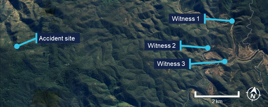
Source: Google Earth, annotated by the ATSB
Further investigation
- examined the site and wreckage
- retained drive shaft components and warning light bulbs for examination
- interviewed witnesses and involved parties
- obtained recorded flight data
- obtained aircraft and operational information
- obtained meteorological information.
The investigation is continuing and will include further review and examination of:
- the mapped accident site and helicopter wreckage
- aircraft and operational documentation
- meteorological information.
A final report will be released at the conclusion of the investigation. Should a critical safety issue be identified during the course of the investigation, the ATSB will immediately notify relevant parties so appropriate and timely safety action can be taken.
Acknowledgements
The ATSB acknowledges the assistance of New South Wales Police, in particular the Lismore Search and Rescue unit.
Purpose of safety investigationsThe objective of a safety investigation is to enhance transport safety. This is done through:
It is not a function of the ATSB to apportion blame or provide a means for determining liability. At the same time, an investigation report must include factual material of sufficient weight to support the analysis and findings. At all times the ATSB endeavours to balance the use of material that could imply adverse comment with the need to properly explain what happened, and why, in a fair and unbiased manner. The ATSB does not investigate for the purpose of taking administrative, regulatory or criminal action. About ATSB reportsATSB investigation reports are organised with regard to international standards or instruments, as applicable, and with ATSB procedures and guidelines. Reports must include factual material of sufficient weight to support the analysis and findings. At all times the ATSB endeavours to balance the use of material that could imply adverse comment with the need to properly explain what happened, and why, in a fair and unbiased manner. An explanation of terminology used in ATSB investigation reports is available here. This includes terms such as occurrence, contributing factor, other factor that increased risk, and safety issue. Publishing informationReleased in accordance with section 25 of the Transport Safety Investigation Act 2003 Published by: Australian Transport Safety Bureau © Commonwealth of Australia 2026 
Ownership of intellectual property rights in this publication Unless otherwise noted, copyright (and any other intellectual property rights, if any) in this report publication is owned by the Commonwealth of Australia. Creative Commons licence With the exception of the Commonwealth Coat of Arms, ATSB logo, and photos and graphics in which a third party holds copyright, this report is licensed under a Creative Commons Attribution 4.0 International licence. The CC BY 4.0 licence enables you to distribute, remix, adapt, and build upon our material in any medium or format, so long as attribution is given to the Australian Transport Safety Bureau. Copyright in material obtained from other agencies, private individuals or organisations, belongs to those agencies, individuals or organisations. Where you wish to use their material, you will need to contact them directly. |
[1] Eastern Standard Time (EST): Coordinated Universal Time (UTC) + 10 hours
[2] Eastern Daylight-saving Time (EDT): Coordinated Universal Time (UTC) + 11 hours
[3] WebTrak uses information from air traffic control secondary surveillance radars to display aircraft movements.
[4] In a graphical area forecast (GAF), all cloud heights are above mean sea level (AMSL).
[5] Cloud cover: in aviation, cloud cover is reported using words that denote the extent of the cover – ‘few’ indicates that up to a quarter of the sky is covered, ‘scattered’ indicates that cloud is covering between a quarter and a half of the sky, ‘broken’ indicates that more than half to almost all the sky is covered, and ‘overcast’ indicates that all the sky is covered.
[6] Weather coverage is given as isolated if it consists of individual features which affect, or are forecast to affect, an area with a maximum spatial coverage of up to 50%.
[7] AIRMET provides information of certain meteorological phenomena that are not contained in the current area forecast.
[8] A TAF is a coded statement of meteorological conditions expected at an aerodrome and within a radius of 5 nautical miles of the aerodrome reference point.
[9] Weather Underground provides local and long-range weather forecasts, weather reports, maps and tropical weather conditions for locations worldwide.
[10] The National Environmental Satellite, Data, and Information Service (NESDIS) manages the United States environmental satellite programs, and manage the data gathered by the National Weather Service and other government agencies and departments.
[11] Solar irradiance is the power per unit area or electromagnetic radiation received from the sun, measured in Watts per square metre.
[12] Visual flight rules (VFR): a set of regulations that permit a pilot to operate an aircraft only in weather conditions generally clear enough to allow the pilot to see where the aircraft is going.
[13] Visual Meteorological Conditions (VMC): an aviation flight category in which visual flight rules (VFR) flight is permitted – that is, conditions in which pilots have sufficient visibility to fly the aircraft while maintaining visual separation from terrain and other aircraft.
Occurrence summary
| Investigation number | AO-2026-067 |
|---|---|
| Occurrence date | 13/03/2026 |
| Occurrence time and timezone | 10:59 Australian Eastern Daylight Time |
| Location | About 46 km north-east of Tenterfield Airport |
| State | New South Wales |
| Report release date | 30/04/2026 |
| Report status | Preliminary |
| Anticipated completion | Q3 2026 |
| Investigation level | Short |
| Investigation type | Occurrence Investigation |
| Investigation phase | Final report: Internal review |
| Investigation status | Active |
| Mode of transport | Aviation |
| Aviation occurrence category | Collision with terrain |
| Occurrence class | Accident |
| Highest injury level | Fatal |
Aircraft details
| Manufacturer | Robinson Helicopter Co |
|---|---|
| Model | R44 II |
| Registration | VH-TCF |
| Serial number | 11912 |
| Aircraft operator | Tasklake Pty Ltd |
| Sector | Helicopter |
| Operation type | Part 91 General operating and flight rules |
| Activity | General aviation / Sport and pleasure flying / Pleasure and personal transport |
| Departure point | Gold Coast Airport, Queensland |
| Destination | Armidale Airport, New South Wales |
| Injuries | Crew - 1 (fatal) |
| Damage | Destroyed |