

Final report
Report release date: 09/10/2026
Investigation summary
What happened
Shortly after sunset on 2 October 2025, the pilot of a Cirrus SR22T, registered VH‑XXO, on a private flight from Wangaratta Airport, Victoria, commenced an approach in instrument meteorological conditions via a standard arrival route (STAR) for runway 35 at Canberra Airport, Australian Capital Territory.
During the descent the aircraft flew below a STAR minimum altitude restriction. The approach controller alerted the pilot and then provided assistance for the descent by providing step clearances.
The controller cleared the pilot for an instrument landing system (ILS) approach. While reprogramming the flight management system (FMS), the pilot did not turn the aircraft towards the airport as required at the last waypoint of the STAR.
The controller provided vectors to line up with an approach to runway 30 before clearing the pilot for a visual approach once the pilot had the runway in sight.
During the visual approach, the pilot received a terrain awareness warning system (TAWS) 'terrain, pull up' alert, and levelled out in response. The pilot then resumed the descent and landed.
What the ATSB found
The pilot experienced a high cognitive workload during the descent, particularly around the time when the approach clearance was issued, since they were not prepared for that type of clearance. Other factors that contributed to this workload included: instrument meteorological conditions on descent, turbulence, FMS usage, and a nighttime approach into a relatively unfamiliar controlled airport.
During the initial stage of the arrival, the pilot descended below the minimum altitude restriction due to mistakenly interpreting the phrase ‘descend via STAR’ to mean they were being requested to descend at that time.
Later, the aircraft flew through the turn at the final stage of the STAR while flying an ILS approach. The approach controller had issued the pilot with an ILS approach in accordance with the published priority order based on the Aeronautical Information Publication, and the absence of a request for different approach on the flight plan. However, although the pilot had not informed air traffic control of their instrument approach preference, the pilot was not expecting to fly an ILS approach and had pre‑programmed the FMS for a different approach. Instead of asking the controller for a different approach the pilot attempted to comply with the clearance and tried to reprogram the FMS in addition to managing a further stepped descent using the autopilot.
Likely associated with a high controller workload, the controller was not aware at the time that there had been a change to nighttime and subsequently applied daytime procedures, issuing clearances and vectors when the aircraft was below the minimum vectoring altitude (MVA).
After accepting the controller's instruction to conduct a visual approach, the pilot then descended below the cleared altitude and flew well below the approach slope and lowest safe altitude without having established visual reference to the precision approach path indicator (PAPI) lights. After receiving the TAWS alert and levelling out, the pilot established the correct slope for the remainder of the descent.
Safety message
The approach and landing phases for single pilot instrument flight are typically periods of high workload, in particular at night in turbulent conditions. This creates challenges in maintaining a correct and stable approach profile. Workload is likely to be reduced when a pilot is proficient in using their aircraft’s navigation systems, and familiar with the approach procedures for their destination, helping them effectively manage their approach.
Pilots should advise controllers of their preferred approach type, either through their flight plan or when in contact with the relevant controller, and the Airservices Aeronautical Information Publication states that a pilot must advise air traffic control immediately if they are unable to comply with a clearance. Furthermore, if finding themselves in a demanding, high-workload situation in controlled airspace, pilots can ask the controller for assistance, or conduct a missed approach to ensure continuing safety.
The occurrence
Take-off, cruise and initial descent
On 2 October 2025 at 1750 local time, during daylight, the pilot of a Cirrus SR22T, registered VH‑XXO departed Wangaratta Airport, Victoria, for an instrument flight rules (IFR) private flight to Canberra Airport, Australian Capital Territory, with the pilot and one passenger on board.
An overview of the approach, descent and landing is provided in Figure 1 and Figure 2. During cruise the pilot contacted air traffic control (ATC) and was cleared to track direct to waypoint POLLI, to commence the POLLI 9 ALPHA standard arrival route (STAR) (see Arrival and approach information) for runway 35 at Canberra. The STAR was commenced shortly after sunset.
Figure 1: Approach from cruise to landing
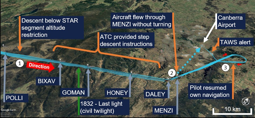
Figure 2: Aircraft altitude from cruise to landing
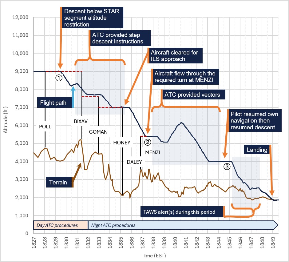
The STAR had a requirement to not descend below 9,000 ft1 until after the waypoint BIXAV. As the aircraft approached waypoint BIXAV, the approach controller, based in Melbourne, provided the following clearance: ‘when ready descend via the STAR to 7,000 [ft]’. The pilot asked the controller to repeat the clearance, which the controller did. The pilot read back the descent clearance, then read back the ‘via STAR’ condition in a second transmission. The pilot believed that they were cleared to descend immediately, and at 1829:29, the pilot commenced a descent from the cruising altitude of 9,000 ft (point ① on the diagrams).
As the aircraft descended through about 8,700 ft, the controller identified the early descent and attempted to confirm the previous clearance with the pilot, which the pilot read back correctly. The controller instructed the pilot to climb to 9,000 ft, which the pilot read back, and the pilot began climbing shortly after. Then, to help the pilot regain the STAR descent profile, the controller advised the pilot they would issue instructions to step descend and provided a clearance to temporarily leave controlled airspace (that is, to fly below the STAR lower altitude limit).
The pilot recommenced descent, and the aircraft became compliant with the STAR altitude restrictions when passing waypoint BIXAV at about 8,000 ft at 1831:26. The aircraft did not descend below the STAR lowest safe altitude (LSALT) or minimum sector altitude (MSA).2
At 1832:00, as the aircraft was descending through approximately 7,700 ft and approaching waypoint GOMAN, civil twilight ended and it became night in terms of the applicable air traffic control procedures (see Air traffic control information). At around this time, the pilot reported they broke through the bottom of the cloud and visibility (other than the darkness) became ‘perfectly clear’ but with turbulence.
Flight through waypoint MENZI and vectoring below MVA
At 1835:14, just after the aircraft passed waypoint HONEY, the controller cleared the pilot for an instrument landing system (ILS) approach to runway 35.3 The pilot had been expecting to conduct a required navigation performance (RNP) approach4 and had pre‑programmed the aircraft’s flight management system (FMS) with the RNP approach as part of their approach preparation. The pilot had been expecting to be issued an RNAV approach for runway 35 (see Arrival and approach information) but did not advise ATC. Instead, the pilot attempted to reprogram the FMS for the ILS approach (which the FMS was capable of doing). The pilot later reported that during this period, they felt ‘overloaded’ with a workload of about 9 out of 10.
The approach required a left turn at waypoint DALEY, and then almost immediately, a second slight left turn at the last waypoint (MENZI, the initial approach point) onto the runway heading. The aircraft turned left at waypoint DALEY towards MENZI as required, completing the turn at about 1837:02. The aircraft levelled out at 5,400 ft, due to the vertical mode changing, and the lateral navigation mode changed, or was changed, to ‘wings level’ as the aircraft headed towards MENZI.5 A few seconds later at 1837:26, the aircraft flew through the localiser at MENZI for runway 35 without turning left towards the runway as required (Figure 3, point ②).
Figure 3: Flight path once the standard arrival route (STAR) was discontinued
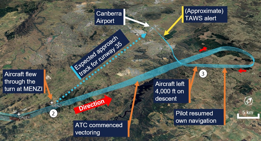
The approach controller identified the lateral deviation and offered the pilot radar vectors.6 Immediately after this transmission, before the pilot had responded, flight data indicated that the FMS vertical mode changed to VPTH (vertical navigation path), which allows the aircraft to attain a set altitude (at that time, set to 1,400 ft) while following pre‑programmed altitude restrictions. The aircraft then descended below the 5,400 ft minimum vector altitude (MVA) (see Lowest safe altitudes).
At about the same time, the pilot accepted the controller’s offer of vectors. At 1838:24, the controller cancelled the approach and issued an instruction to continue on their current heading and climb to 7,000 ft, which the pilot read back.
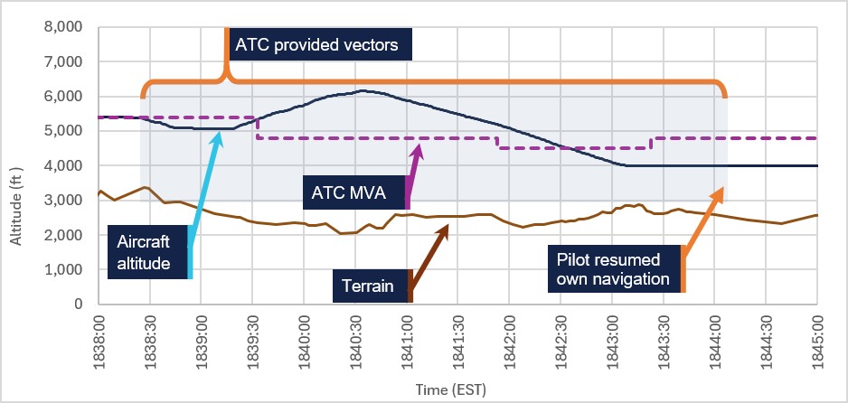
The aircraft levelled out a few seconds later. The pilot reported attempting to climb but that there was a downdraft from the turbulence. Flight data indicated that the FMS vertical modes changed about 4 times during this period, and the power setting did not change. At 1839:14, the controller issued the pilot a low altitude warning safety alert. The aircraft began to climb with increased power immediately after this. As the aircraft climbed, it passed into an area with a lower MVA of 4,800 ft MSL and climbed above that altitude at 1839:32.
The tower controller (located in Canberra) asked the approach controller whether the pilot was visual. The approach controller (who was still in contact with the pilot) then asked the pilot at 1840:00 and the pilot advised that they were. The controller asked whether the pilot wanted more track miles, and the pilot responded in the affirmative and stated that they could do a visual approach. The controller cleared the pilot to descend to 4,000 ft ‘visual’ at 1840:27 and the aircraft started descending again. The aircraft had climbed to about 6,100 ft at this point and was in an area where the MVA was 4,800 ft.
At 1842:00, the controller commenced issuing vectors (turns) to position the aircraft for an approach to runway 30, beginning with a long right turn initially to the east and continuing to the west. The aircraft descended below the MVA, which was 4,500 ft in that area, at 1842:36.
Terrain awareness alerts and landing
The aircraft levelled at 4,000 ft at 1843:11 and then entered an area where the MVA increased to 4,800 ft. At 1844:03, the approach controller asked the pilot if they had the runway in sight, which the pilot affirmed. The controller responded ‘resume own navigation, cleared visual approach runway 30’ and instructed them to contact the tower controller.
The pilot maintained 4,000 ft until 1845:11, then commenced a further descent (point ③ on the diagrams) just prior to turning onto final for runway 30. The pilot reported conducting a visual descent by reference to the runway and using the PAPI as a ‘crosscheck’ for the descent profile. The pilot later reported that, at this time, they could identify 2 white and 2 red lights on the PAPI (which would indicate the correct descent profile).
During the final approach to runway 30, the aircraft maintained a descent profile below the 3.9° nominal approach angle (see Recorded information). ATSB analysis of likely PAPI indications based on the recorded data is provided in Flight path analysis.
At 1846:10 the pilot contacted Canberra tower. The tower controller, having discussed the flight with the approach controller, asked the pilot to confirm they had the runway in sight, and the pilot replied in the affirmative.
The pilot recalled that as the aircraft approached about 2–3 NM (3.7–5.5 km) from the runway, a terrain awareness and warning system (TAWS) alert ‘terrain, pull up’ activated. In response, the pilot levelled the aircraft. The pilot advised the ATSB that they could see the runway lights ahead and discern the horizon but could not see the ground below.
Flight data did not record TAWS data; ATSB analysis of the recorded flight path indicated that there were several periods throughout this part of the descent where TAWS caution(s) and/or warning(s) were possible (see Flight path analysis).
During one of these periods, the aircraft levelled out at about 2,500 ft (approximately 500 ft above ground level) for about 30 seconds, before descending further to a landing at 1849:06.
Context
Pilot information
The pilot rated their fatigue level as ‘fully alert’ (the lowest of 7 points on the Samn-Perelli scale) at the time of the occurrence. They held a Private Pilot Licence (Aeroplane) with a single engine aircraft class rating and a private IFR rating (PIFR). The pilot had 1,607 hours total aeronautical experience and had flown 22 hours in the last 90 days.
The pilot’s last private instrument rating proficiency check was conducted on 17 March 2024 and was valid until 31 March 2026.
The pilot held the following applicable operational authorisations (among others) for their private IFR rating:
- NGT A allows a pilot to fly an aircraft of the specified category under the IFR at night (this is an authorisation only valid for the private IFR rating).
- 2D IAP allows a pilot to fly a 2D instrument approach procedure (IAP) both laterally, and vertically to comply with any descent limitations of the procedure (such as altitude restrictions on a STAR).
- Approval to conduct RNP and ILS approaches, erroneously recorded at the time as an IAP 3D authorisation (see below).
In the last 12 months, the pilot had conducted 30 instrument approaches, of which 29 were RNP approaches into regional airports (not Canberra). The other approach was an ILS flown into Canberra on 14 March 2025.
The pilot met the night recency requirements, (allowing them to carry passengers at night), having conducted more than 3 take-offs and landings within the last 90 days.
The pilot understood that they were authorised to conduct an ILS approach as an outcome of their private instrument flight rating test that was conducted on 13 March 2016 on the basis of a handwritten entry ‘IAP 3D’ made by an instructor on their licence at the time. IAP 3D is not the correct terminology for a private instrument rating; the correct endorsement recording of an ILS flight procedure authorisation (FPA) on a private IFR rating is to add ILS to the list of FPAs.
The operational endorsement was not reflected on the printed licence held by the pilot or the electronic records held by the Civil Aviation Safety Authority (CASA) at the time of the occurrence. The ATSB was unable to determine the reason for this discrepancy. After the occurrence, CASA advised that the pilot was appropriately authorised to conduct an ILS approach.
Controller information
The approach controller had been an air traffic controller since 2015, had been working the Canberra approach position for about 6 months, and held the appropriate qualifications and rating for the role. They reported fatigue at level 3 ('okay, somewhat fresh') on the Samn-Perelli 7-point fatigue scale at the time of the occurrence. The controller reported that workload at the time was generally low, but the requirement to manage the occurrence aircraft made the total workload high.
Aircraft information
The Cirrus Design Corporation SR22T is a low-wing general aviation aircraft with 4 or 5 seats and a single turbocharged piston engine, driving a constant-speed 3-blade propeller. VH‑XXO, serial number 8710, was manufactured in the United States in 2022 and first registered in Australia on 12 January 2023 to the pilot, who was the registered operator. The aircraft was certified for day and night visual flight rules (VFR) and IFR operations.
Avionics instrumentation and automatic flight control system
The aircraft was equipped with the Cirrus Perspective integrated avionics system developed by Garmin. Flight instrumentation, position, navigation, communication, and identification information were displayed through a primary flight display (PFD) and a multifunction display (MFD). An automatic flight control system (AFCS) fully integrated within the integrated avionics system architecture provided flight director and autopilot functions and multiple vertical and lateral navigation modes.
The AFCS included a flight management system (FMS) that could provide guidance commands for navigation directives such as loading approaches, tracking to waypoints and tuning and identifying navigation aids. A touchscreen, buttons and keyboard allowed user control and input.
Terrain alerting and warning system
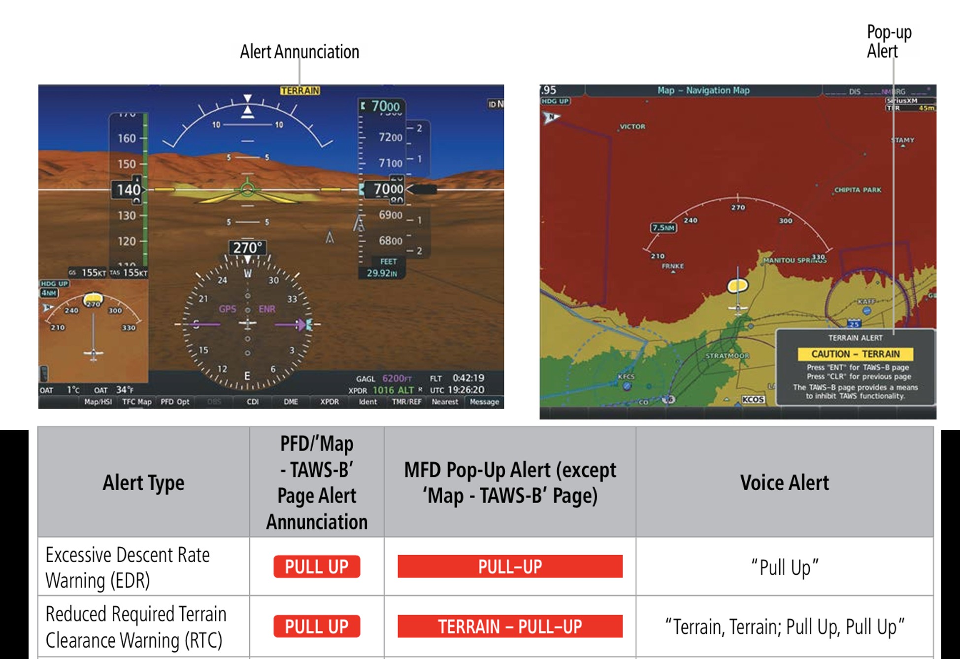
The aircraft’s avionics system included a TAWS certified by the United States Federal Aviation Administration (FAA). The TAWS is a system designed to provide visual and auditory advisory alerts to a pilot if their aircraft is in immediate danger of flying into the ground or an obstacle. In VH‑XXO, terrain alerts were displayed in red and yellow shading on the primary flight display (PFD) and MFD (Figure 4). The Cirrus pilot operating manual did not provide guidance on the actions to take in response to a TAWS alert.
Garmin synthetic vision technology (SVT) is an optional visual enhancement to the system that was fitted to VH‑XXO. SVT depicts a forward-looking display of the topography immediately in front of the aircraft, derived from the system’s internal database.
Figure 4: Synthetic vision and terrain awareness warning system alerts
Meteorological and lighting information
The pilot reported that some of the descent and approach was conducted in cloud and it was ‘very turbulent’ below 7,000 ft, which affected their ability to make selections on the flight management computer.
At 1830 the Bureau of Meteorology weather station at Canberra Airport recorded the following weather conditions:
- wind 280° at 12 kt
- greater than 10 km visibility
- cloud cover7 was ‘few’ at 4,487 ft AMSL, ‘scattered’ at 5,587 ft AMSL and ‘overcast’ at 6,287 ft AMSL.8
The observations at 1900 had wind in the same direction at 14 kt, with the only cloud reported being ‘scattered’ at 5,600 ft AMSL.
At the time of the arrival and approach, the terminal area forecasts (TAFs) forecast moderate to severe turbulence below 5,000 ft with intermittent showers and rain.
Sunset in the region was at 1807 and the end of evening civil twilight,9 the start of night for aviation purposes, was at 1832. In Melbourne, where the approach controller was located, the end of civil twilight was at 1851.
Airport information
The elevation of Canberra Airport is 1,886 ft. Runway 30 was equipped with a precision approach path indicator (PAPI). This system used a set of lights that provided visual guidance for the pilots to help establish and maintain the correct approach slope (vertical glide path or angle). When flying a normal approach path, an equal number of red and white lights would be seen by the pilot (Figure 5). If an aircraft is below the nominal approach slope, there would be more red lights than white, and above the slope, more white lights than red would be visible.
Figure 5: Generic PAPI light indications (not to scale)
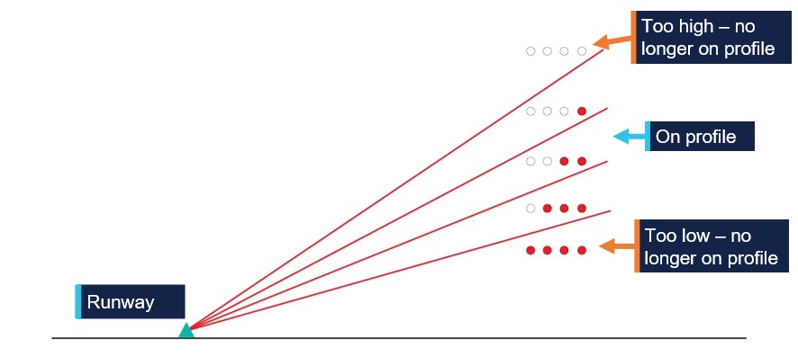
The approach slope for runway 30 was 3.9° and the PAPI lights changed indication with approach slope. When close to the nominal slope, 2 red and 2 white lights would be visible (this is called ‘on profile’ or ‘on slope’). It is generally acceptable to allow 3 red or 3 white lights to be visible. For runway 30 at Canberra, 3 red lights would be visible on an approach of less than about 3.65°, and 4 red lights would be visible on an approach of less than about 3.32°. The standard, and most common, slope for runways without high terrain on approach is 3.0°.
Arrival and approach information
A standard arrival route (STAR) is a series of waypoints with speed and/or altitude restrictions to guide aircraft towards a runway for an approach to landing. The Canberra POLLI 9 ALPHA STAR is shown in Figure 6. Lowest safe altitudes (LSALT) are shown above each segment, and the altitude restrictions are shown below each waypoint name. A line beneath the number means that the aircraft must remain at or above the given altitude.
Figure 6: POLLI 9 ALPHA standard arrival route
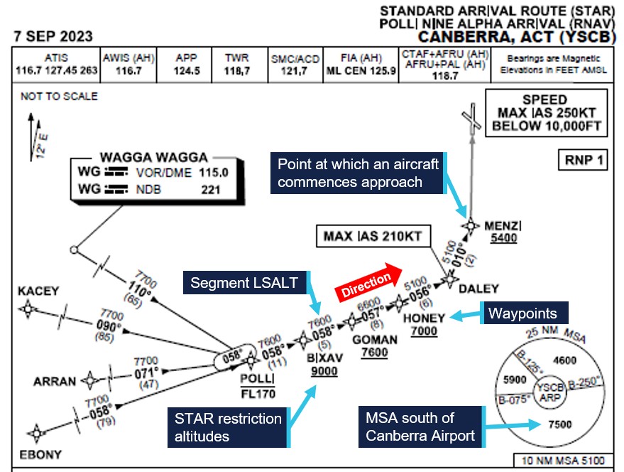
At the end of a STAR, in this case when the aircraft passes MENZI, pilots commence the approach itself. In general, this may be a visual approach or instrument approaches such as an ILS, RNP, or others. The Airservices Aeronautical Information Publication (AIP) En Route requires pilots on a visual approach at night to maintain the last assigned altitude when being vectored, and not to descend below the lowest safe altitude, until certain conditions are met, including the aircraft being ‘not below “on slope” on the … PAPI’ (which means the pilot must see at least 2 white lights on the PAPI). The AIP requires pilots to plan to fly the first available procedure listed on the chart for that runway, which in this case was an ILS approach. Controllers issue approaches in the same order, unless requested otherwise by the pilot, via radio or through the submitted flight plan.
Air traffic control information
Minimum vector altitude
When an IFR flight is being vectored by radar, the controller may assign altitudes which are below the LSALT or MSA used by pilots. Minimum vector altitude (MVA), colloquially known as the ‘radar lowest safe altitude’, is the lowest altitude that an air traffic controller may issue altitude clearances. Controllers were not permitted to vector aircraft below a minimum vectoring altitude (MVA) at night.
Day and night procedures
When night (defined as the end of civil twilight) came into effect, controllers could clear an IFR aircraft for a visual approach while complying with the MVA. When issuing a visual approach at night the phraseology used by controllers was different to that used during daytime. In daytime the instruction is in the form:10
CLEARED VISUAL APPROACH (runway number)
At night the required phraseology to be used was:
WHEN ESTABLISHED ON THE VASIS11 (or PAPI) (or GLIDEPATH) CLEARED VISUAL APPROACH
The approach controller for this occurrence reported they were aware of the correct phraseology, had applied the phraseology multiple times in the past, and had the intention to use the phraseology once night came into effect. However, they did not use the night phraseology on this occasion as they were not aware that night had come into effect.
Airservices Australia had no documented process to alert controllers at the end of civil twilight. According to the approach controller, individual controllers could use various methods to make them aware of the change of time of day like using a timer alarm or a note. The approach controller did not use a reminder in this instance.
The approach controller was located in Melbourne, at a console with a view outside.
Flight plan information and presentation
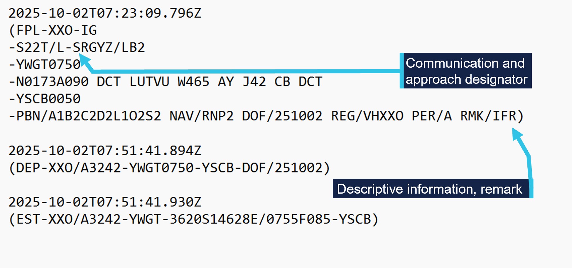
The flight plan notification submitted by the pilot to Airservices indicated to ATC what serviceable equipment was available on the aircraft and whether the pilot was qualified to use that equipment (Figure 7).
The IFR designator should have been PIFR (private IFR) with a listing of specific capabilities. The IFR designator here instead indicates that the pilot and aircraft had multiple capabilities that indicated a full instrument rating rather than a PIFR. With a PIFR rating, the flight plan should list specific capabilities.
Figure 7: Flight notification
Recorded information
Flight path analysis
Figure 8 shows the results of ATSB analysis of what the pilot probably would have seen on the PAPI, and periods during which TAWS alerts were calculated to be possible. There were 4 possible periods that TAWS caution(s) may have occurred and 3 possible periods of TAWS warning(s). The aircraft levelled out for about one minute from about 1846:50, which coincided with one of the possible TAWS warning points.
Figure 8: Indication of possible TAWS alerts
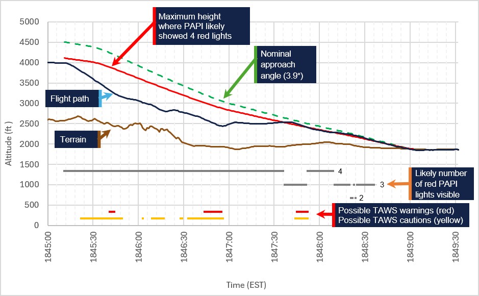
From the commencement of the descent from 4,000 ft, the pilot probably would have seen 4 red lights on the PAPI until 1845:37 (about 2.5 minutes) for a few seconds, then 4 red lights again for a few more seconds. After that, PAPI would have shown 3 red lights for most of the remainder of the approach until almost reaching the runway.
Autopilot and FMS modes
The autopilot was engaged for the entire arrival and approach with vertical and lateral control of the aircraft being made using various modes. The pilot changed vertical modes about 23 times throughout this period. The autopilot was disconnected when the aircraft was about 285 ft above the runway.
Air traffic control vectoring
The MVA at the aircraft’s location during the period of being vectored by the approach controller is shown in Figure 9.
Figure 9: Air traffic control vectoring period and MVA
Related occurrences
Cessna Citation Mustang (AO-2022-061)
On 16 November 2022, a Cessna Citation Mustang approached Bankstown Airport to land under the IFR, about 10 minutes after last light. The pilot was conducting a visual approach and descended to about 800 ft below the lowest safe altitude for the area. The controller issued a terrain safety alert.
The ATSB found that the pilot followed the rules applicable to day operations as there was still some ambient light available to allow features on the ground to be visually identified and avoided. This resulted in the pilot descending below the lowest safe altitude applicable for operations at night.
Aero Commander 500-S (AO-2021-033)
On 12 August 2021, an Aero Commander 500-S aircraft in IMC began descending below its assigned altitude, which was also the minimum sector altitude. The approach controller issued 3 terrain safety alerts.
The ATSB found that the pilot experienced data entry difficulties due to turbulent conditions. Several other factors, including the environmental conditions, data entry difficulties and the timing of the clearance, likely led to the pilot experiencing a high workload. This in turn, likely affected the pilot’s situational awareness where they continued descent and descent below the assigned (minimum sector) altitude.
Piper Saratoga PA-32R (AO-2011-043)
On 30 March 2011, a Piper Saratoga PA-32R aircraft on final approach to Moree Airport, New South Wales, struck a tree and collided with terrain. The pilot and 3 passengers were fatally injured and the 3 other passengers were seriously injured.
The ATSB found that there was a misinterpretation of the available visual cues for maintaining glidepath, which probably affected the pilot's ability to assess and correct the aircraft's low final approach altitude. This resulted in the pilot continuing the approach despite being below the normal approach profile.
Safety analysis
Pilot cognitive workload
The arrival and approach was conducted at night, in turbulence, and initially in cloud, while the pilot had only flown one approach into a major airport (Canberra) in the last 12 months. These conditions are conducive to a high workload. For example, a study conducted by Dodd and others (2014) found that while operating in moderate turbulence, it took pilots over 2 minutes longer to complete a given task when compared to operating in no turbulence. In this case, the pilot reported experiencing a high workload (9 out of 10) during the latter part of the STAR when they received the unexpected ILS clearance and were attempting to reprogram the aircraft’s flight management system (FMS).
Contributing factor The pilot was experiencing high cognitive workload demands during the arrival and approach as a result of severe turbulence, a night approach in instrument meteorological conditions, a controlled airport with which the pilot was not highly familiar, and being issued an approach type that the pilot was not expecting. |
Missed turn at waypoint MENZI
The aircraft made a left turn at waypoint DALEY as required, and levelled out, but did not make the required turn at waypoint MENZI (the initial approach point). Two minutes before the aircraft reached MENZI, the controller cleared the pilot for an ILS approach for runway 35. As per the AIP requirements, the controller issued the first available procedure listed on the chart for that runway, which was an ILS approach, as the pilot had not requested a different approach through the flight plan or verbally to the controller. However, even though the pilot had not informed air traffic control of their preference, they were not expecting to fly an ILS approach and had pre-programmed the FMS for a different approach. Instead of asking the controller for a different approach the pilot attempted to comply with the clearance and tried to reprogram the FMS in addition to managing a further stepped descent using the autopilot. Possibly in an attempt to reduce workload, the pilot then changed the autopilot modes to maintain the current altitude with wings level. While doing all these tasks in turbulence and experiencing a very high workload, the pilot likely became task focused on the FMS and the aircraft flew through the waypoint without turning.
Contributing factor The pilot did not inform air traffic control of their instrument approach preference, and then accepted an approach for which they had not prepared. The pilot then focused their attention on managing autopilot modes and programming the flight management system. As a result, the aircraft did not turn as required at the initial approach point. |
Controller’s use of daytime procedures at night
During daytime operations an air traffic controller can issue a clearance that allows a pilot to descend visually. However, at night or in instrument meteorological conditions, the degraded visual environment limits the ability for a pilot to identify obstacles and terrain. Consequently, procedures and ATC phraseology differ at night in comparison to the day.
A controller is not permitted to vector the aircraft below the minimum vectoring altitude (MVA) at night. In this case, the approach controller cleared the aircraft to descent below the MVA about 8 minutes after the point at which night procedures applied, and continued to vector the aircraft below the MVA for about 5 minutes during the approach.
In addition, the approach controller used daytime phraseology to issue the visual approach clearance instead of the nighttime phraseology. Unlike the daytime clearance, the nighttime clearance for a visual approach reminds a pilot to maintain their assigned altitude until established on the PAPI. The controller had the intention to use the phraseology once night came into effect, but did not realise that it was now night in Canberra.
The controller’s intention to switch to night procedures at the appropriate time is an example of prospective memory. Prospective memory, or ‘remembering to remember’, is an intention to perform an action in the future. In prospective memory, the main challenge is not remembering intentions but recalling them when they need to be carried out. Research has indicated that an individual is unlikely to remember to do so unless they get a timely retrieval cue from the environment (Dismukes 2010; Harrison and others, 2014).
In this case, the controller had not set up a reminder cue. Their physical location and different local time for the end of civil twilight would have made their environmental cues inaccurate. In addition, the controller reported that managing the occurrence aircraft resulted in a high workload, which can increase the likelihood of error.
Contributing factor Likely associated with a high workload, the approach controller was not aware that the time of transition from daytime to nighttime procedures had passed and, as a result, provided clearances and vectors for the aircraft below the minimum vectoring altitude (MVA). |
Air traffic control prompts for transition to night procedures
Airservices did not standardise or mandate the use of reminders for controllers to transition between procedures at the applicable times of day. As a result, there was an ongoing risk that controllers would apply the incorrect procedures, as occurred in this instance. This risk is somewhat mitigated by the fact that controllers would generally realise and correct such an error before long, and pilots themselves would be able to manage their flight path safely as they would outside of controlled airspace.
Contributing factor The application of air traffic control procedures was reliant on individual controllers remembering the time of civil twilight (last light) and using individual methods to keep track of the time, for the change to night procedures. |
Descent below cleared altitude and alert
At night, a pilot is required to stay above the applicable safe altitude limits or the ATC cleared altitude until established on the correct approach profile to land; during this approach, the correct profile was indicated by the PAPI. The clearance for a visual approach used the daytime phraseology which did not remind the pilot of the requirement to establish the correct profile using the PAPI, and the pilot descended below the cleared altitude of 4,000 ft when commencing the visual approach to runway 30.
The pilot reported that they were conducting a visual descent using the runway as a point of reference and referencing the PAPI as a crosscheck. The nominal slope throughout this part of the approach for runway 30 was 3.9°. This is significantly steeper than the standard (and most common) approach slope (3.0°), so judging the approach slope from the runway appearance would be likely to result in an approach that is too low unless this difference is accounted for. On a 3.0° approach into this runway, a pilot would see 4 red lights on the PAPI.
Analysis of recorded data indicated that the aircraft was very likely below the lowest angle at which 2 red and 2 white lights would have been visible for the entire approach. The recorded data therefore indicates the pilot was likely descending without any reference to the PAPI. As the ground below was not visible, the pilot could not have had a reliable awareness of their proximity to terrain.
The pilot likely would have seen 4 red lights constantly, until after the TAWS warning (which most likely occurred at about 1846:50, at about 500 ft above the aerodrome elevation). It is uncertain whether the pilot would have received a TAWS caution prior to the ‘pull up’ warning. In response to this alert, the aircraft remained level until about the time one white PAPI light was probably visible (that is, the correct profile had been intercepted). From that point the correct approach profile was followed, apart from a brief period below the minimum slope, a steady descent rate was re-established.
Contributing factor The pilot descended below the cleared altitude without having established visual reference to the precision approach path indicator (PAPI) lights, and remained well below the correct vertical profile until alerted by the terrain awareness warning system (TAWS). |
Descent below standard arrival route (STAR) altitude restriction
While the aircraft was in the cruise at 9,000 ft, the controller issued the pilot with a clearance to descend ‘via [the] STAR’ to 7,000 ft. The pilot incorrectly interpreted the clearance as an instruction to descend (immediately) without realising that the phrasing meant that they needed to comply with the altitude restrictions. As a result, the aircraft descended too early, and below the 9,000 ft altitude restriction.
Other factor that increased risk On receiving the clearance to descend ‘via the STAR’ (standard arrival route) to 7000 ft, the pilot mistakenly believed they were being requested to descend at that time and descended below a STAR altitude restriction. |
Findings
ATSB investigation report findings focus on safety factors (that is, events and conditions that increase risk). Safety factors include ‘contributing factors’ and ‘other factors that increased risk’ (that is, factors that did not meet the definition of a contributing factor for this occurrence but were still considered important to include in the report for the purpose of increasing awareness and enhancing safety). In addition ‘other findings’ may be included to provide important information about topics other than safety factors. These findings should not be read as apportioning blame or liability to any particular organisation or individual. |
From the evidence available, the following findings are made with respect to the descent below lowest safe altitude and ground proximity involving Cirrus SR22T, VH‑XXO, at Canberra Airport, Australian Capital Territory, on 2 October 2025.
Contributing factors
- The pilot was experiencing high cognitive workload demands during the arrival and approach as a result of severe turbulence, a night approach in instrument meteorological conditions, a controlled airport with which the pilot was not highly familiar, and being issued an approach type that the pilot was not expecting.
- The pilot did not inform air traffic control of their instrument approach preference, and then accepted an approach for which they had not prepared. The pilot then focused their attention on managing autopilot modes and programming the flight management system. As a result, the aircraft did not turn as required at the initial approach point.
- Likely associated with a high workload, the approach controller was not aware that the time of transition from daytime to nighttime procedures had passed and, as a result, provided clearances and vectors for the aircraft below the minimum vectoring altitude (MVA).
- The application of air traffic control procedures was reliant on individual controllers remembering the time of civil twilight (last light) and using individual methods to keep track of the time, for the change to night procedures.
- The pilot descended below the cleared altitude without having established visual reference to the precision approach path indicator (PAPI) lights, and remained well below the correct vertical profile until alerted by the terrain awareness warning system (TAWS).
Other factors that increased risk
- On receiving the clearance to descend ‘via the STAR’ (standard arrival route) to 7,000 ft, the pilot mistakenly believed they were being requested to descend at that time and descended below a STAR altitude restriction.
Sources and submissions
Sources of information
The sources of information during the investigation included:
- the pilot
- the approach controller
- Civil Aviation Safety Authority
- aircraft manufacturer
- Airservices Australia
- Flightradar24
- recorded data from the aircraft.
References
Department of Transport United States Goverment. (n.d.). Controlled flight into Terrain Educational and Training Aid. Retrieved from Skybrary: https://skybrary.aero/sites/default/files/bookshelf/2507.pdf
Dodd, S., Lancaster, J., Miranda, A., Grothe, S., DeMers, B., & Rogers, B. (2014). Touch Screens on the Flight Deck: The Impact of Touch Target Size, Spacing, Touch Technology and Turbulence on Pilot Performance. Proceedings of the Human Factors and Ergonomics Society 58th Annual Meeting, 58(1), 6-10.
Submissions
Under section 26 of the Transport Safety Investigation Act 2003, the ATSB may provide a draft report, on a confidential basis, to any person whom the ATSB considers appropriate. That section allows a person receiving a draft report to make submissions to the ATSB about the draft report.
A draft of this report was provided to the following directly involved parties:
- the pilot
- the approach controller
- Civil Aviation Safety Authority
- Airservices Australia.
Submissions were received from:
- the pilot
- the approach controller
- Airservices Australia.
The submissions were reviewed and, where considered appropriate, the text of the report was amended accordingly.
Purpose of safety investigationsThe objective of an ATSB safety investigation is to improve transport safety through:
In accordance with the TSI Act, the ATSB does not investigate for the purpose of taking administrative, regulatory or criminal action, and cannot apportion blame, assist in determining liability, or, as a general rule, assist in court proceedings. About ATSB reportsATSB safety investigation reports are developed in accordance with ATSB procedures and guidelines, and with regard to applicable international standards and instruments. Reports must include factual material of sufficient weight to support the investigation’s analysis and findings. At all times the ATSB endeavours to balance the use of material that could imply adverse comment with the need to properly explain what happened, and why, in a fair and unbiased manner. An explanation of terminology used in ATSB investigation reports is available here. Publishing informationReleased in accordance with section 25 of the Transport Safety Investigation Act 2003 Published by: Australian Transport Safety Bureau © Commonwealth of Australia 2026 Ownership of intellectual property rights in this publication Unless otherwise noted, copyright (and any other intellectual property rights, if any) in this report publication is owned by the Commonwealth of Australia. Creative Commons licence 
With the exception of the Commonwealth Coat of Arms, ATSB logo, and photos and graphics in which a third party holds copyright, this report is licensed under a Creative Commons Attribution 4.0 International licence. The CC BY 4.0 licence enables you to distribute, remix, adapt, and build upon our material in any medium or format, so long as attribution is given to the Australian Transport Safety Bureau. Copyright in material obtained from other agencies, private individuals or organisations, belongs to those agencies, individuals or organisations. Where you wish to use their material, you will need to contact them directly. |
- ^ All altitudes in the report are above mean sea level (AMSL) unless otherwise stated.
- ^ The lowest altitude for a given area which will provide a minimum clearance of 1,000 ft above terrain and obstacles.
- ^ The order for the issue of an approach is based on set procedures, within the aircraft and pilot capabilities indicated on the flight plan.
- ^ RNP approach (RNP APCH) procedures are instrument approach procedures based on area navigation (lateral and/or vertical) that includes the requirement for on-board performance monitoring and alerting features.
- ^ ‘Wings level’ maintains wings level without actively maintaining any particular heading. The recorded data did not indicate whether the mode changes were automatic (based on the programmed navigation sequence), or manual.
- ^ Vectoring: provision of navigational guidance to aircraft, in the form of assigned headings, based on the use of an air traffic services surveillance system such as radar.
- ^ Cloud cover: in aviation, cloud cover is reported using words that denote the extent of the cover – ‘few’ indicates that up to a quarter of the sky is covered, ‘scattered’ indicates that cloud is covering between a quarter and a half of the sky, and ‘overcast’ indicates that all the sky is covered.
- ^ These altitudes were provided relative to the airport elevation, and have been converted to AMSL.
- ^ Defined as the instant in the evening, when the centre of the sun is at a depression angle of 6° below an ideal horizon. At this time in the absence of moonlight, artificial lighting or adverse atmospheric conditions, the illumination is such that large objects may be seen but no detail is discernible.
- ^ Airservices Aeronautical Information Publication (AIP) General.
- ^ VASI: visual approach slope indicator, a lighting system with a similar function to PAPI but with lights arranged in 2 rows of 3.
Occurrence summary
| Investigation number | AO-2025-061 |
|---|---|
| Occurrence date | 02/10/2025 |
| Occurrence time and timezone | 1847 Australian Eastern Standard Time |
| Location | Canberra Airport |
| State | Australian Capital Territory |
| Report release date | 09/10/2026 |
| Report status | Final |
| Investigation level | Short |
| Investigation type | Occurrence Investigation |
| Investigation phase | Final report: Dissemination |
| Investigation status | Completed |
| Mode of transport | Aviation |
| Aviation occurrence category | E/GPWS warning, Flight below minimum altitude, Information/procedural error, Operational non-compliance |
| Occurrence class | Incident |
| Highest injury level | None |
Aircraft details
| Manufacturer | Cirrus Design Corporation |
|---|---|
| Model | SR22T |
| Registration | VH-XXO |
| Serial number | 8710 |
| Sector | Piston |
| Operation type | Part 91 General operating and flight rules |
| Activity | General aviation / Recreational-Own business travel |
| Departure point | Wangaratta Airport, Victoria |
| Destination | Canberra Airport, Australian Capital Territory |
| Injuries | None |
| Damage | Nil |