
Discontinuation notice
Report release date: 26/03/2026
Section 21 (2) of the Transport Safety Investigation Act 2003 (TSI Act) empowers the ATSB to discontinue an investigation into a transport safety matter at any time. Section 21 (3) of the TSI Act requires the ATSB to publish a statement setting out the reasons for discontinuing an investigation. The statement is published as a report in accordance with section 25 of the TSI Act, capturing information from the investigation up to the time of discontinuance.
Overview of the investigation
On 20 August 2023, 2 Embraer ERJ 190-100 IGW aircraft, registered VH-UZI (UZI), and VH-XVS (XVS) were conducting air transport flights. Both aircraft were operated by Alliance Airlines.
UZI was operating as Qantas flight 1948 from Hobart, Tasmania, to Brisbane, Queensland, and was tracking in a northerly direction maintaining flight level[1] (FL) 350. XVS was operating as Qantas flight 1907 from Brisbane to Canberra, Australian Capital Territory, and was in a climb tracking in a southerly direction. Both aircraft were flying in a section of airspace referred to as ‘Byron’ and were in communication with a controller at Brisbane Centre air traffic control (the controller). Within the Byron airspace, the controller was operating 2 sectors, ‘Inverell’ and ‘Gold Coast’.
At 1523:15 local time, the flight crew of XVS entered the Gold Coast sector and contacted the controller and were instructed to climb to FL 360. About 4 minutes later, and while climbing through FL 200, XVS turned left slightly onto air route[2] H91 on a track of 190° (magnetic).
At 1536:46, UZI entered the Inverell sector on air route H66 on a track of 30° (magnetic). The flight crew contacted the controller advising that they were maintaining FL 350, with the controller providing instructions for arrival at Brisbane. Between 1540:56 and 1541:42, the controller provided instructions to 2 other aircraft.
At 1541:55, when both aircraft were in the vicinity of the waypoint TESSI, a short-term conflict-alert[3] (STCA) between XVS and UZI activated and was displayed on the controller’s screen. The relative position of each aircraft at the time of the STCA activation is shown in Figure 1. At this time, UZI was maintaining FL 350 and XVS was climbing through FL 345, with the captain of XVS reporting a climb rate of 700 ft/min. The aircraft were separated by approximately 25 NM (46 km) with a closure rate of about 900 kt and 20° off a reciprocal track.
At about the same time as the STCA activation, the following exchange occurred between the controller and the flight crew of XVS:
Controller: Qantas nineteen zero seven…just confirm maintain flight level three six zero
XVS: Maintain flight level three six zero Qantas nineteen zero seven.
At 1542:06, shortly after the STCA activation, the controller issued avoiding action instructions to both aircraft, with the following radio transmissions occurring:
1542:06 Controller: Qantas nineteen forty-eight avoiding action turn left heading two seven zero
1542:10 UZI: Left turn heading two seven zero Qantas nineteen forty-eight
1542:14 Controller: Qantas nineteen forty-seven descend immediately flight level three four zero
1542:21 Controller: Qantas nineteen zero seven descend immediately flight level three four zero
1542:25 XVS: Descend three four zero Qantas nineteen zero seven
The captain of UZI reported that immediately after receiving the instruction, the first officer dialled the heading bug to 270° (magnetic) that was coupled to the autopilot, with the aircraft starting to respond to the commanded direction change. The captain of XVS reported that after hearing the controller’s instruction to UZI, they were anticipating an instruction from the controller, and as a result, the flight crew of XVS commanded a descent to FL 340 ‘pretty quickly’ after receiving the instruction.
At 1542:48, the controller further queried both flight crews about their position with the follow exchange occurring:
1542:48 Controller: Qantas nineteen forty eight, you turning?
1542:51 UZI: Affirm
1542:53 Controller: Qantas nineteen zero seven, descending? Report maintaining three four zero
1542:57 XVS: Ahh, descending past three four five Qantas nineteen zero seven
While this exchange was occurring, the captains of both aircraft reported observing traffic advisory indications for the other aircraft on the traffic alert and avoidance system.[4] Additionally, both captains recalled hearing a traffic advisory[5] with an audible key phrase ‘Traffic’ generated by this system as the aircraft passed each other.
Subsequently, at 1543:17, the following radio transmissions were broadcast:
1543:17 XVS: Qantas nineteen zero seven is maintaining flight level three four zero.
1543:21 ATC: Qantas nineteen forty-seven, correction nineteen zero seven.
1543:23 ATC: Qantas nineteen forty-eight, clear of conflict, cleared now direct to…IDDNA
As a result, while the separation did not reduce below the standard of 5 NM (9 km) horizontally and 1,000 ft vertically, the emerging conflict between the 2 aircraft was not initially identified and managed resulting in a loss of separation assurance.[6]
Figure 1: Position of VH-UZI and VH-XVS shown on en route high charts during the STCA activation
Source: Airservices Australia and Geoscience Australia, annotated by the ATSB
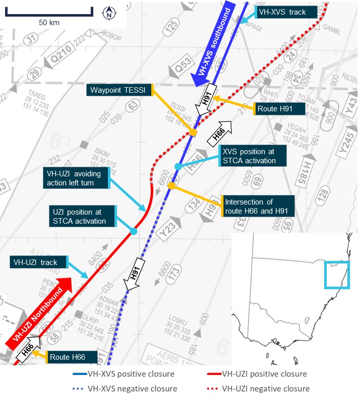
Figure 2 shows simplified track information for the incident in the upper portion of the figure, similar to Figure 1, and additionally includes altitude information for the 2 aircraft along the track in the lower portion. Key waypoints are labelled for reference in the upper ‘track’ plot. The light grey lines show the air routes, denoted by arrow labels. The lower ‘Altitude’ plot shows the aircraft altitude at the same latitude as the upper plot.
The southbound flight path of XVS along route ‘H91’ is shown in blue, and the northbound flight path of UZI starting on route ‘H66’ is shown in red. The areas in Figure 2 labelled ‘Closest point’ show the relative location of the avoiding action turn conducted by UZI on the upper plot and altitude changes by XVS on the lower plot. The solid blue (XVS) and solid red (UZI) lines show the flight path as the aircraft approached each other, and the dotted lines show the flight path as the aircraft started to move away from each other.
The tracks in the area of ‘Closest point’ boxes of Figure 2 show that XVS was approaching the same level of UZI (FL 350) near the crossing point between route H91 and H66. At 1543:14, the aircraft were separated by about 6 NM (11 km) as XVS approached FL 340, 1,000 ft below UZI.
Figure 2: Tracks (upper graph) and altitudes (lower graph) of VH-XVS (blue lines) and VH‑UZI (red lines) during the loss of separation assurance at 1542
Note: Positive closure refers to a positive closure rate, when the aircraft were converging toward each other, while negative closure is where the aircraft were diverging. Source: ATSB
Related occurrences
A search of the ATSB’s occurrence database was conducted to identify similar events to the incident flight for this investigation. An additional 2 occurrences were identified involving conflicts between aircraft climbing southbound on air route H91 and northbound on routes H66 or Y23. The occurrences were dated 15 May 2023 and 3 July 2023. These are described below.
ATSB occurrence OA2023-00783
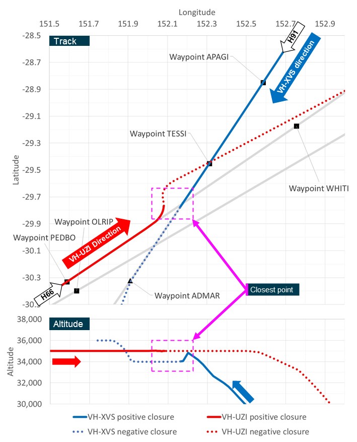
On 15 May 2023, a 737-800 aircraft (B737) was in the cruise at FL 350 from Melbourne, Victoria, to Gold Coast Airport, Queensland. At the same time, an Embraer ERJ 190‑100 IGW (E190) aircraft was in a climb after departing Brisbane, Queensland, en route to Canberra, Australian Capital Territory. Both aircraft were conducting air transport flights. This is depicted in Figure 3 in the same way as Figure 2 above.
The B737 was travelling north along route ‘Y23’ (red lines in Figure 3), and the E190 was travelling south on route ‘H91’ (blue lines in Figure 3). At 1150, an STCA alert identifying a conflict between the aircraft was noticed by the Byron airspace controller.
Airservices Australia reported that the controller issued an instruction to the B737 flight crew to immediately turn right onto a heading of 040°. Following readback, the controller issued an instruction to the E190 flight crew to immediately turn right onto a heading of 230°.
The flight crew of the E190 initially responded requesting confirmation of the instruction, which was re-issued by the controller. The controller advised the conflict had not been identified until alerted. As a result, there was a loss of separation assurance.
The flight paths in the ‘Closest point’ boxes of Figure 3 shows that the E190 had climbed through the same level of the B737 (FL 350) just prior to both aircraft starting to turn right. ATSB analysis showed that, at this time, the aircraft had a similar closure rate to the occurrence incident (between XVS and UZI) of about 916 kt. Airservices Australia reported that the closest point between the aircraft was approximately 7.2 NM (13 km) following the turns.
Figure 3: Tracks (upper graph) and altitudes (lower graph) of the E190 (blue lines) and B737 (red lines) during loss of separation assurance
Source: ATSB
ATSB occurrence OA2023-03542
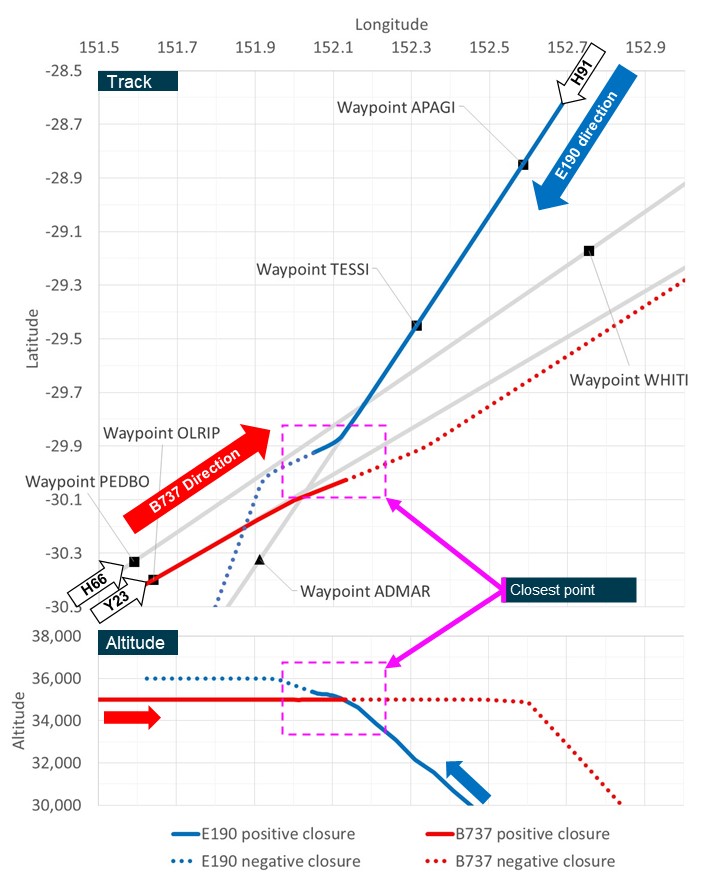
On 3 July 2023, an Airbus A321-231 (A321) aircraft was in the cruise at FL 330 from Melbourne, Victoria, to Sunshine Coast Airport, Queensland. At the same time, an Airbus A320-232 (A320) aircraft was in a climb after departing Brisbane, Queensland, en route to Launceston, Tasmania. Both aircraft were conducting air transport flights. This is depicted in Figure 4 in the same way as Figure 2 and Figure 3 above.
The A321 was travelling north along route ‘H66’ (red lines in Figure 4), and the A320 was travelling south on route ‘H91’ (blue lines in Figure 4). Airservices Australia reported that the A320 was on climb and was assigned FL 340. At approximately 1409, an STCA alerted the controller to a conflict between the aircraft. As a result, there was a loss of separation assurance.
The controller issued avoiding action to the A320 with an instruction to turn right and maintain FL 320. The controller subsequently also issued avoiding action to the A321 to turn right. Figure 4 shows that the A320 levelled out near FL 320 at the time that both aircraft starting to turn right, and just after the A321 had passed waypoint TESSI.
Figure 4: Tracks (upper graph) and altitudes (lower graph) of the A320 (blue lines) and the A321 (red lines) during the loss of separation assurance
Source: ATSB
Comparative analysis of flight paths
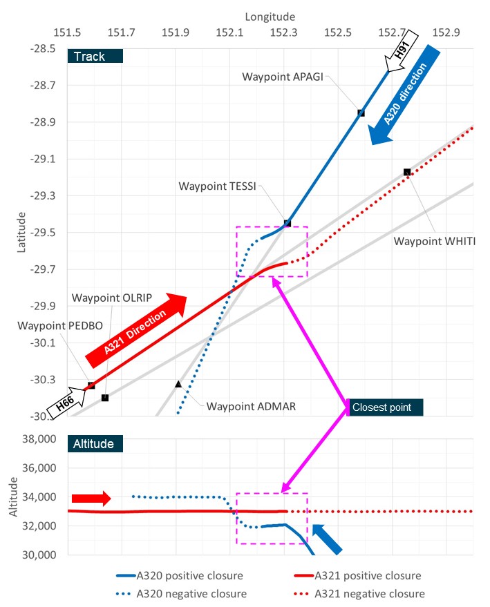
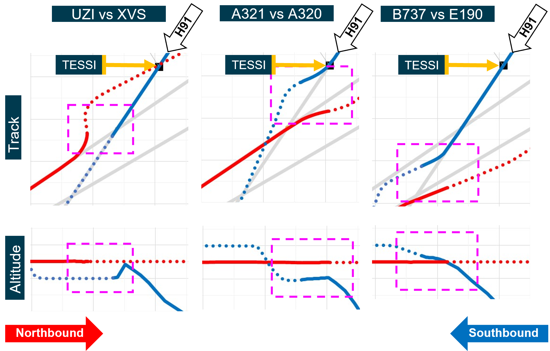
The ATSB compared the flight paths of all 3 incidents on 15 May, 3 July and 20 August 2023 (this investigation). The flight tracks and relative altitude for each of the 6 aircraft involved are shown in Figure 5.
Figure 5 uses the same data as Figure 2, Figure 4 and Figure 3, with the pink box showing the closest point for each incident in the same locations as in these figures. As in the above figures, solid lines show the flight paths as the aircraft approached each other, with the dotted lines showing the flight paths as the aircraft moved away from each other. The upper ‘Track’ plots are shown in the same location for all incidents, with waypoint ‘TESSI’ and route ‘H91’ labelled for reference. The light grey lines show the other air routes as labelled in the figures above. The lower ‘Altitude’ plots are shown with the same latitude (corresponding to the upper plots, although with the altitude adjusted to be centred on the northbound aircraft cruise level.
Figure 5: Comparison of flight paths involving a loss of separation assurance on air route 91 near waypoint TESSI between 15 May and 20 August 2023
Source: ATSB
Comparison of the 3 incidents depicted in Figure 5 showed:
- All southbound aircraft were on route H91 in a climb and had not reached the assigned altitude.
- Two of the southbound aircraft (the A320 and E190) turned right in response to the conflict, with the track of VH-XVS remaining straight.
- Two of the southbound aircraft (XVS and the A320) stopped or reversed the climb, with separation maintained by attaining 1,000 ft separation.
- Of the 3 incidents, the E190 was the slowest climbing aircraft to reach the conflict altitude, leading to the conflict with the B737 on route Y23.
- The northbound aircraft were all in cruise on air route H66 or Y23.
- In all cases, the northbound aircraft remained in cruise during each incident, with the responding avoiding action being a left or right deviation from the published air route.
Safety action
The following section describes safety action taken by Airservices Australia in response to the incident of this investigation, and the 2 other incidents noted in the Related occurrences section.
Issue of standardisation directive
On 22 August 2023, 2 days after the incident related to this investigation, Airservices Australia published standardisation directive DIR_23_0055 (the directive). This directive was specific to staff working on the Byron airspace in Brisbane Centre air traffic control. This provided the following context:
In the last 3 months there have been 3 occasions where the STCA has alerted controllers to a potential conflict in the vicinity of the TESSI waypoint. Each time the controller had issued climb to the southbound aircraft through the level of a maintaining northbound aircraft.
Each time the controller had issued the climb they either decided to monitor the separation or did not pick up the conflict.
The directive specified that there would be focus by Airservices Australia employees with roles as air traffic service workplace assessors (ATSWpA’s) on maintaining separation assurance between southbound aircraft on route H91 and northbound aircraft on route H66:
There will now be a focus by Byron group ATSWpA’s that separation assurance is maintained at all times between aircraft tracking southbound on H91 and aircraft tracking northbound on H66.
Byron ATSWpA’s will monitor the group compliance with separation assurance requirements, to be clear it is not acceptable to just monitor the climb of a conflicting pair of aircraft.
The directive also provided some detail on options to mitigate the risk of the southbound aircraft climbing into the path of the northbound aircraft:
If in doubt controllers are to issue either a requirement or an intermediate level. Controllers are reminded that issuing climb with a requirement to reach a level by TESSI to southbound aircraft on H91 will ensure separation with crossing northbound aircraft below on H66.
The standardisation directive expired on 21 November 2023.
Change to airspace design of ATS route H91
On 10 July 2024, Airservices Australia finalised a review for the incident related to this investigation. This review proposed further safety action relating to these conflicts in the vicinity of TESSI. This included:
• ATS [air traffic service] Route H91 - It was identified through occurrence review that inadequate separation assurance occurrence was linked to current crossing point between H91 and H66 routes
• Aircraft tracking south on H91 are still on climb and the position of the crossing point is at a distance where both aircraft would be at approximately the same level as H66 without ATC [air traffic control] intervention.
• Proposal to amend H91, new waypoint 6nm NW [11 km] of the H91/H66 crossing point and then track to [waypoint] ADMAR to rejoin the route, proposal has been sim validated by Byron ATC.
• The route from [waypoints] APAGI – TESSI – ADMAR to be removed
On 14 May 2025, Airservices Australia advised the ATSB the airspace change had been validated using simulator trials.
This process involves putting the new route into one of the Byron training simulator exercises that has the TESSI crossover incorporated. The new route is added and the results evaluated with simulator traffic. The simulator testing was valuable and resulted in a slight amendment to the planned waypoint.
On 12 June 2025, the proposed changes to the airspace design came into effect. A review of the en route high chart 1 that became effective on 12 June 2025 showed an alteration to air route H91 to include APAGI – CLIFF – ADMAR. As noted in the proposed changes, the new waypoint CLIFF was 6 NM (11 km) north-west of the original H91/H66 crossing point. For reference, a section of this new route H91 is depicted in yellow in Figure 6. Note that route Y23 changed names to route Y54 after these incidents. The changes to route H91 increased the track miles by 11.9 NM (22 km) to the crossing point with route H66, and by 4.9 NM (9 km) to the crossing point with route Y23 (now Y54).
Figure 6: New route H91 shown in yellow over en route high chart dated 12 June 2025
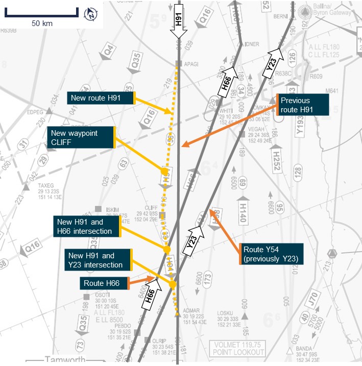
Source: Airservices Australia, annotated by the ATSB
Assessment of safety action
ATSB assessment of airspace changes
The ATSB assessed the changes to air route H91 on the 3 incident flights. This analysis was performed by projecting the flight paths of all 3 southbound climbing aircraft involved in the incidents on air route H91 onto the new route H91. The projected location of each aircraft at the flight level of the northbound conflicting aircraft were estimated based on the actual average climb performance, prior to air traffic control intervention.
Based on the climb performance achieved, all 3 climbing incident aircraft would have passed through the altitude of the opposing aircraft prior to the new crossing point of H91 and H66. However, the analysis of the southbound climbing aircraft for the incident of this investigation (XVS) and ATSB occurrence OA2023-00783 indicated that these aircraft would have likely been within 5 NM (9 km) of air route H66 prior to reaching 1,000 ft vertical separation with the conflict flight level (FL 350).
Therefore, the ATSB’s analysis of the airspace changes indicated that the likelihood of a conflict between aircraft in similar circumstances to these incidents has been reduced by the increase in track miles and spacing between routes prior to the crossing points. However, the possibility of a loss of separation from slow-to-climb aircraft still existed in 2 of the 3 incidents.
Response by Airservices Australia
On 14 May 2025, Airservices Australia provided the following comment about the ATSB’s assessment of the airspace changes:
In relation to the ATSB analysis noting ‘the possibility of a loss of separation from slow-to-climb aircraft still exists’, that is technically accurate, however it is also the reason Air Traffic Control exists. At some point arrival and departure tracks cross at most of our major ports in Australia. The Air Traffic Controller on the relevant sector is trained to recognise the conflict and to provide the appropriate solution whether that be to stop climb, issue climb requirements or vector. The reason a H91/TESSI route change was put forward as a safety improvement was that the current climb and descent profiles of aircraft had added an increased risk of climb/descent conflictions at the H91/H66 crossing point. The route change shifts the crossing point to a better position and gives departing the aircraft more track miles to get to their planned level and arriving aircraft more time to commence descent.
ATSB asked Airservices Australia to advise on any other controls in place to mitigate the risk of a conflict between slow-to-climb aircraft on route 91 and aircraft in cruise on route H66 following the expiry of the standardisation directive. They advised that the controls in place while waiting for the route change to be processed were:
• Discussions with the Director Operations, the Line Leader, CSS [check and standardisation supervisor] and senior controllers in regard to TESSI and the importance of issuing requirements.
• Confirmation from CSS [check and standardisation supervisor] and senior controllers that the TESSI crossover was a major part of the Byron training package.
• A focus on the TESSI crossover and the issuing and monitoring of requirements by the Byron CSS during observations and checks.
Airservices Australia also advised that no similar on-climb conflicts had been identified since the release of the standardisation directive and the CSS (check and standardisation supervisor) focus on the crossover between route H91 and the northbound routes. Airservices Australia advised of another scenario where the STCA alarm activated, although this related to an aircraft being permitted to descend early in the proximity of the crossing of H91 and H66. There was no loss of separation for this incident.
Reasons for the discontinuation
The ATSB strives to use its limited resources for maximum safety benefit and considers that in this case the likelihood of a conflict between aircraft has been reduced by the increase in track miles and spacing between routes prior to the crossing points. The ATSB accepts that this airspace change, combined with existing risk controls, such as air traffic control and conflict alert systems have adequately controlled the risk of conflicts in similar circumstances to these incidents at this location and, as such, has reduced the likelihood of a loss of separation from slow-to-climb aircraft. Consequently, the ATSB has discontinued this investigation.
[1] Flight level: at altitudes above 10,000 ft in Australia, an aircraft’s height above mean sea level is referred to as a flight level (FL). FL 350 equates to 35,000 ft.
[2] Air route: a specified route designed for channelling the flow of traffic as necessary for the provision of air traffic services.
[3] Short-term conflict-alert (STCA): the STCA in Airservices Australia’s Australian Advanced Air Traffic System (TAAATS) determines all of the possible surveillance track pairs for which, in a predefined period, the minimum separation between each track pair will be less than the minimum safety requirements.
[4] Traffic alert and avoidance system (TCAS): a type of airborne collision avoidance system (ACAS).
[5] Traffic advisory (TA): an alert issued by an airborne collision avoidance system (ACAS) when the detected traffic may result in a conflict. Pilots are expected to initiate a visual search for the traffic causing the TA.
[6] A loss of separation assurance is an occurrence where separation has been maintained but has not been planned, actioned or monitored appropriately.
Occurrence summary
| Investigation number | AO-2023-039 |
|---|---|
| Occurrence date | 20/08/2023 |
| Location | 86 km west of Grafton Airport |
| State | New South Wales |
| Report release date | 26/03/2026 |
| Report status | Discontinued |
| Investigation level | Defined |
| Investigation type | Occurrence Investigation |
| Investigation status | Discontinued |
| Mode of transport | Aviation |
| Aviation occurrence category | Loss of separation assurance |
| Occurrence class | Incident |
| Highest injury level | None |
Aircraft details
| Manufacturer | Embraer-Empresa Brasileira De Aeronautica |
|---|---|
| Model | ERJ 190-100 IGW |
| Registration | VH-XVS |
| Serial number | 19000062 |
| Aircraft operator | Alliance Airlines Pty Limited |
| Sector | Jet |
| Operation type | Part 121 Air transport operations - larger aeroplanes |
| Departure point | Brisbane Airport, Queensland |
| Destination | Canberra Airport, Australian Capital Territory |
| Damage | Nil |
Aircraft details
| Manufacturer | Embraer-Empresa Brasileira De Aeronautica |
|---|---|
| Model | ERJ 190-100 IGW |
| Registration | VH-UZI |
| Serial number | 19000191 |
| Aircraft operator | Alliance Airlines Pty Limited |
| Sector | Jet |
| Operation type | Part 121 Air transport operations - larger aeroplanes |
| Departure point | Hobart Airport, Tasmania |
| Destination | Brisbane Airport, Queensland |
| Damage | Nil |