
Executive summary
What happened
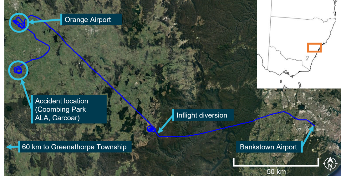
In the afternoon of 4 November 2020, a training flight was conducted in an Aquila AT01, registered VH‑OIS (OIS) which departed Bankstown Airport with a Grade 1 flight instructor and a student onboard. The flight was conducted to assess the readiness of the student to complete the commercial pilot licence flight test for aeroplanes. The flight continued normally, proceeding to Coombing Park Aeroplane Landing Area (ALA), where the student demonstrated the conduct of a precautionary search, an expected exercise during this flight. However, following the precautionary search, a touch‑and‑go was performed. During the subsequent climb away from the runway, the aircraft collided with terrain. Both pilots received fatal injuries.
What the ATSB found
The ATSB found that pre-flight planning was likely not performed to identify if Coombing Park ALA was suitable for flight training operations. This placed more importance on the conduct of the precautionary search to identify the rising terrain hazard in the overshoot area of the runway. The precautionary search was conducted at a height and position that likely made assessing the hazard less effective, leading to the pilots deciding to conduct a touch-and-go landing and take-off toward the rising terrain beyond the runway end. Further, the take-off was conducted on an uphill slope with a probable tailwind. A standing take-off in the more favourable reciprocal direction would likely have cleared all obstacles and terrain.
Although the touch-and-go was typical of those conducted by the student, it likely used more runway than if a standing take-off was conducted, leading to the aircraft becoming airborne further along the runway, and closer to the rising terrain. Consequently, although the aircraft was likely performing normally, the aircraft had insufficient performance to outclimb the rising terrain in any direction once established on the initial climb after take-off.
The ATSB also found that the operations manual used for flight training that was based on the CASA sample operations manual allowed the use of any aerodrome (including ALAs) in the Enroute Supplement Australia to be used, although these were not assured to any operational standard. Further, the recommendations contained in CASA guidance CAAP 92-1(1) (although subsequently replaced by AC 91-02 as noted below) did not provide assurance that an aircraft would be able to outclimb rising terrain after take-off more than 900 metres from the runway end.
What has been done as a result
CASA advised that legislation and guidance relating to obstacle clearance in the approach and take-off areas of ALAs was introduced on 2 December 2021. Included in these changes were the replacement of CAAP 92-1(1) with Advisory Circular AC 91-02 titled ‘Guidelines for aeroplanes with MTOW not exceeding 5,700 kg – suitable places to take-off and land’ (the AC).
In contrast to CAAP 92-1(1), the AC included guidance for a pilot to consider and be aware of ‘lateral transition areas’ and ‘obstacles in the approach and climb-out flight paths’, in deciding if an aerodrome is suitable for operations. Further, the introduced regulations require that pilots ensure that the aeroplane has the performance to clear all obstacles by a safe margin until at the minimum height for flight.
Safety message
This investigation shows that the lift-off location following a touch-and-go is more variable and complex to predict than a standing take-off. In this case, the touch-and-goes conducted throughout the flight consistently used more runway than a standing take‑off. This contributed to the aircraft lifting off from a point where the available climb performance of the aircraft was not sufficient to outclimb the rising terrain. This characteristic is particularly important for flights to unfamiliar aerodromes, where the aerodrome characteristics should be considered to confirm if a touch‑and‑go is feasible, particularly for uncertified aerodromes. Additionally, as was the case here, the runway slope, wind and rising terrain at one runway end may mean that the optimal landing and take-off directions are in opposing directions, which cannot be achieved when conducting a touch-and-go.
The investigation also highlights the value of following operator’s procedures as an important risk control to aid planning and in-flight decision making. For this accident, the operator’s procedures did not allow landings to be conducted at the aerodrome where the accident occurred. This meant that the execution of the precautionary search was one of the last remaining defences to identify the rising terrain hazard during take-off, which was ineffective.
Operators should also be aware that aerodromes meeting the recommendations in the CASA guidance publication CAAP 92-1(1) (now obsolete) are not assured that an aircraft will be able to successfully climb away after take-off more than 900 metres past the runway end. The new performance-based recommendations of AC 91-02 now require operators to consider obstacle clearance beyond 900 metres. Flight training operators should also note that there are no standards for ALAs (listed in the ERSA as uncertified aerodromes). The published data for these uncertified aerodromes are potentially incomplete or inaccurate, including obstacle information. This means that for take-off from these aerodromes, the new guidance requires pilots and operators to know the climb gradient needed to clear all obstacles by a safe margin until the aeroplane reaches the minimum height for flight.
Pre-flight and departure from Bankstown
In the afternoon of 4 November 2020, a training flight was conducted in an Aquila AT-01 aeroplane, registered VH‑OIS (OIS) between Bankstown Airport and Orange Airport, New South Wales (Figure 1). On board were a Grade 1 flight instructor (the instructor) employed by Soar Aviation (Soar), and a student (the student) of Soar. This flight was required by Soar to assess the readiness of the student to complete the Commercial Pilot Licence (Aeroplane) (CPL(A)) flight test administered by the Civil Aviation Safety Authority (CASA).
Figure 1: Flight path of VH-OIS and accident location
Source: Google Earth and Geoscience Australia, annotated by ATSB.
Automatic Dependent Surveillance Broadcast (ADS-B) data transmitted by OIS (the flight data)[1] indicated the aircraft started to taxi to a run-up[2] bay adjacent to Bankstown Airport runway 29R at 1419. The aircraft remained in the bay for about 5 minutes then, following engine run‑ups, the pilots[3] taxied OIS toward the runway 29R threshold, with take-off commencing at 1431 followed by an upwind[4] departure.
After departing the Bankstown Airport airspace, OIS initially tracked toward the west‑north‑west before turning left onto a west-south-westerly track about 19 km from Bankstown Airport, towards the planned track to Greenethorpe Township, about 220 km away. OIS continued tracking toward Greenethorpe until 1507, when the pilots turned right, tracking north-west toward a grassed area adjacent to the western side of the Blue Mountains.
Diversion to Orange
Flight data indicated that, once overhead the grassed area, the pilots conducted 4 left orbits[5] (blue track in lower centre of Figure 1) at an altitude between 6,000 and 7,000 ft above mean sea level (AMSL). After completion of the orbits, OIS was established on a track in the general direction of Orange township. At 1526, about 6 minutes after setting course toward Orange, the pilots of OIS contacted air traffic control and requested a flight plan amendment from the original track (to a location near Greenethorpe Township) to Orange Airport and back to Bankstown Airport, with no change to the SARTIME. The flight plan amendment and change in track was consistent with the instructor requiring the student to demonstrate an inflight diversion, as labelled in Figure 1.
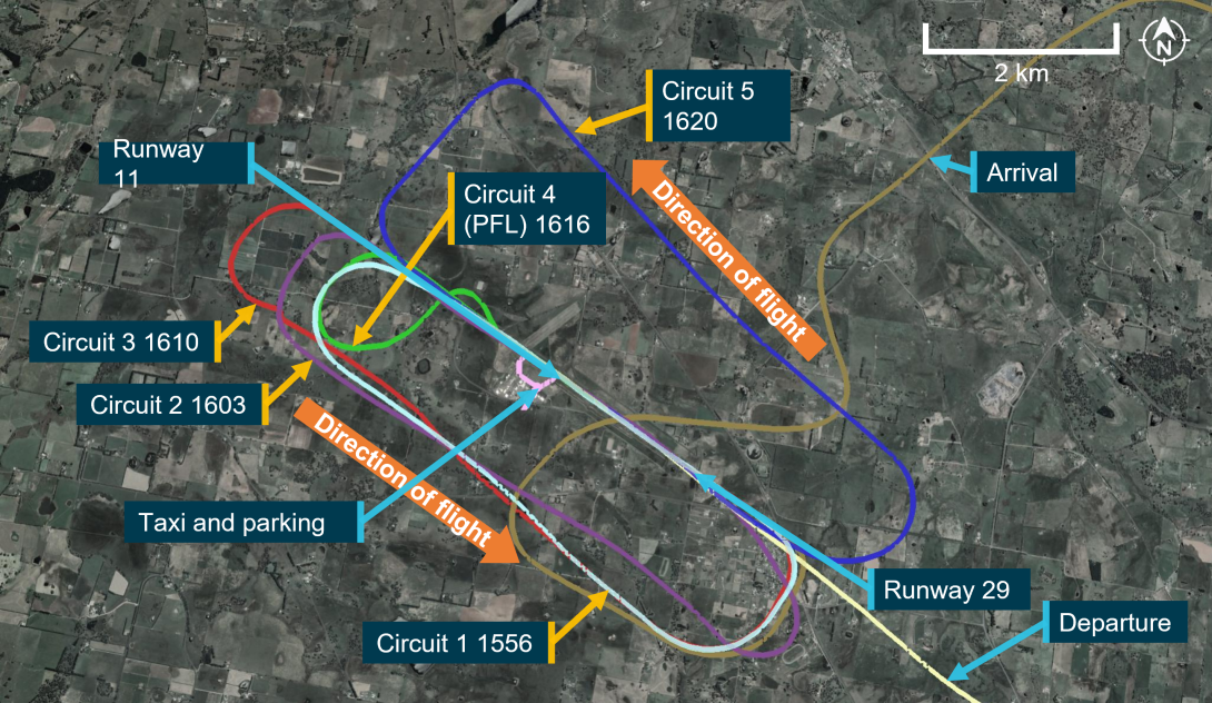
At 1553, the pilots of OIS arrived overhead Orange Airport, and joined the crosswind leg of the circuit for runway 29 for the first of 4 touch-and-go landings and circuits, as shown in Figure 2. Flight data (shown by the green line in Figure 2) and eyewitnesses indicated that after the completion of the fourth touch‑and‑go on runway 29, as OIS was on the late crosswind circuit leg, a descending left turn was conducted, with the aircraft manoeuvred to align with the reciprocal runway 11. A touch-and-go landing was then conducted on runway 11 followed by a left circuit (dark blue line in Figure 2) and full stop landing on this runway at 1726. The pilots taxied to the main parking area at Orange, with flight data indicating the aircraft was stationary for about 1 minute. During this time, photographs taken by an eyewitness and CCTV footage showed the canopy partially opened and the student looking at a map, with other eyewitnesses indicating that the pilots spoke with one another.
Figure 2: Flight path of VH-OIS at Orange Airport
Source: Google Earth, annotated by the ATSB
After a total of 8 minutes on the ground, OIS entered the main runway from the eastern taxiway and backtracked toward the runway 11 threshold. At 1637, the pilots broadcast that they were rolling on runway 11 and an upwind departure was conducted. Flight data indicated that during the initial climb from the runway, OIS maintained a nominal track on the extended runway centreline for about 9 km.
Audio recordings of transmissions from the Orange common traffic advisory frequency (CTAF) indicated that during this time, both pilots of OIS were in communication with an inbound passenger carrying flight. Once at about 9 km from the runway, the pilots of OIS broadcast on the CTAF that they were on a heading of 130° magnetic and levelling out at 5,000 ft AMSL, consistent with the flight data. OIS turned right briefly toward the township of Blayney and then left to proceed on a south-easterly track for about 2 minutes before turning right onto a south-westerly heading in the general direction of the township of Carcoar and Coombing Park aeroplane landing area (ALA).
Operations at Coombing Park
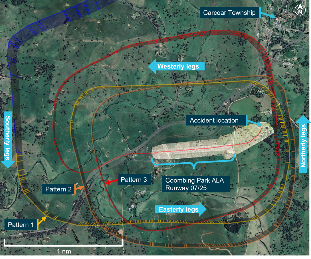
At 1653 a descent was commenced when OIS was abeam Coombing Park ALA, approximately 3 km to the north of the main east-west runway (runways 07 and 25) as shown in Figure 3. The pilots conducted 3 nominally rectangular patterns around Coombing Park runway 07.
At 1704, while on the easterly leg of the third pattern, the instructor of OIS made a phone call to the property manager of Coombing Park that lasted 24 seconds. The property manager recalled the instructor identifying themselves as an instructor from Soar Aviation and requesting permission to conduct a touch-and-go at Coombing Park. The property manager reported that they thought OIS was on the downwind leg for runway 25, and on this basis approved the touch‑and-go.
The pilots positioned OIS to land on runway 07, with flight data showing the aircraft on a descending profile on the base, and final approach circuit legs. The property manager described the final approach as stable and observed OIS descending to very near the ground at the runway 07 threshold. OIS was not visible to the property manager after this time due to their vantage point being slightly below the runway, however the manager, who was also a pilot, indicated that the projected touch-down point would have been very close to the runway 07 threshold based on the observed approach.
Flight data indicated that OIS passed over the runway 07 threshold at 1708, touched down and rolled along the runway surface. About 30 seconds after passing over the runway threshold, OIS become airborne again and commenced a climb, passing through 50 ft AGL approximately 900 m from the start of runway 07.
Figure 3: Flight path of OIS while operating at Coombing Park ALA
Source: Google Earth and Aireon, modified and annotated by the ATSB
During the initial climb, OIS tracked in a straight line angled slightly left of the runway centreline. Flight data indicated that, about 20 seconds later as OIS climbed through 200 ft above the lift-off point, a climbing left turn was conducted by the pilots before flying straight again in the direction of a small dam, beyond which was a less wooded area. OIS passed over the small dam and collided with an embankment on the far side of the dam. A witness heard the sound of the impact, although they did not realise it was an aircraft accident at the time, and there were no eyewitnesses to the accident.
At 1800, air traffic services commenced trying to contact the pilots of OIS via radio. At 1832, after being unsuccessful in contacting the pilots, an INCERFA[6] was declared with the search and rescue response being transferred to the Joint Rescue Coordination Centre. Local authorities were notified, and a search was commenced in the area. At 2157, the wreckage of OIS was located, and it was confirmed that both pilots had sustained fatal injuries.
Context
Pilot information
Flight instructor
Qualifications
The instructor held a valid commercial pilot licence (aeroplane) issued in March 2009, and a flight instructor rating issued in March 2010. The instructor also held a grade 1 training endorsement to instruct in single- and multi-engine fixed wing aeroplanes.
The instructor was also endorsed to conduct training for the issue of instrument and night VFR ratings. They passed a proficiency check for the flight instructor rating on 13 January 2020 that was valid at the time of the accident. Additionally, the instructor’s flight crew licence indicated that they had completed single- and multi-engine aeroplane flight reviews on 13 January 2020 and 28 July 2019 respectively that were also valid.
Experience
A review of the instructor’s logbooks, staff files and flight data showed that at the time of the accident they had accumulated a total flying experience of approximately 3,169 hours. About 16 of those hours were in the previous 30 days and about 56 hours were in the last 3 months. Most of the instructor’s flying experience was in single-engine aeroplanes (3,002 hours), with the instructor recording approximately 2,584 hours of total experience as a CASA‑qualified flight instructor. Staff records indicated that the instructor had accumulated 2,421 hours while working for the operator. The instructor had approximately 569 hours in the AT-01, the same type flown on the day of the accident, with about 33 hours in the last 3 months on that type.
Medical information
The instructor held a Class 1 aviation medical certificate that was valid until 12 June 2021 with no restrictions. The instructor was reported to be fit and active and in a good state of mind in the days before the flight and was likely well-rested. The instructor was not reported to be taking any prescription medications and had no reported medical condition that could have affected their ability to operate an aircraft that day. A post-mortem examination identified no significant background natural disease, which could have contributed to the accident.
Student
Qualifications
The student held a recreational pilot licence for single engine aeroplanes issued in December 2018, with a navigation rating for this licence issued in September 2019. The student also held recreational licence ratings for operations in controlled airspace, operations at controlled aerodromes and for the operation of flight radio. Additionally, the student was endorsed to operate aircraft with manual propeller pitch control. The student’s licence did not have an expiry date and was valid at the time of the flight.
Experience
A review of the student’s logbooks, student files and flight data showed that at the time of the accident the student had accumulated a total flying experience of approximately 259 hours. About 10 of those hours were in the previous 30 days and about 13 hours were in the last 3 months. Operator’s records indicated that the student had accumulated 174 hours while training with the operator, with the remaining 85 hours acquired previously at another flying school. The student had approximately 72 hours in the AT-01, the same type flown on the day of the accident, with all 13 hours flown in the last 3 months being on that type.
Medical information
The student also held a class 1 aviation medical certificate that was valid until 20 October 2021 with no restrictions. The student was reported to be well rested in the days before the flight. The student was not reported to be taking any prescription medications and had no reported medical condition that could have affected their ability to operate an aircraft that day. A post-mortem examination identified no significant background natural disease, which could have contributed to the accident.
Pilot fatigue information
Based on reported sleep data alone, it is unlikely that the crew were fatigued. It is possible that the student may have experienced some mental fatigue due to the assessment nature of the flight. However, there was insufficient evidence to make that determination. Further, the instructor was unlikely to be fatigued at the time of the accident.
Aircraft information
Overview
VH-OIS (OIS) (Figure 4) was an Aquila AT01 fixed-wing aircraft manufactured in 2012. The aircraft was first registered in Australia on 14 December 2012 to Soar Aviation Aircraft Holdings Pty Ltd (Soar). The aircraft was a two-seat, low‑wing training aircraft constructed from carbon fibre and fiberglass. Control surfaces were a mixture of push rod and cable operated. The power plant was a Rotax 912S with a two-blade constant speed propeller.
Figure 4: VH-OIS
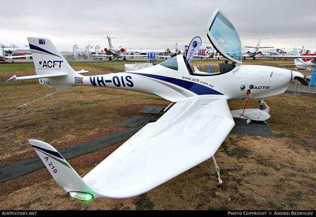
Figure 4 shows VH-OIS on display at Avalon Airshow
Source: Andrei Bezmylov, used with permission
Maintenance
OIS had a current maintenance release located in the aircraft, issued on 1 September 2020 which was valid for a period of 150 hours or 12 months, whichever was sooner. At the time of the accident the aircraft had accrued 31.6 hours since the maintenance release issue and had a total time in service recorded as 3,540.9 flight hours.
The aircraft was maintained to the airframe and engine manufacturer’s inspection schedules with an operational category of aerial work. At the time of the accident, there were no listed defects or outstanding maintenance endorsed on the maintenance release.
Aircraft weight and balance
The aircraft had a valid load data sheet, with the empty weight and centre of gravity data approved on 30 October 2013. Weight and balance calculations performed by the ATSB found that OIS was below maximum take-off weight and within centre of gravity limits for the duration of the flight.
Flight data
The aircraft was not fitted with a flight data recorder or a cockpit voice recorder, nor was either required by regulations. Some Aquila models were fitted with a KAPI electronics flight data recorder, however, the manufacturer advised that this device was not fitted to OIS at the time of manufacture.
The primary source of flight data for OIS on the day of the accident was from satellite-based ADS‑B receivers operated by Aireon. These receivers are onboard the Iridium satellite constellation.
Aerodrome information
Coombing Park was classified as an ‘uncertified’ aerodrome, otherwise known as an aeroplane/aircraft landing area (ALA) and included one primary grass runway, and another shorter grass runway aligned about 70° from the primary runway (Figure 5). Coombing Park had an ICAO designator of YCPK, an elevation of 2,350 ft and had a common traffic advisory frequency (CTAF) of 119.0, shared with Orange Airport. The primary runway was nominally aligned in an east-west direction, at about 73° magnetic (85°T) (designated runway 07/25), and had a length of just over 1,200 m. The shorter runway was about 400 m long and aligned in a south-westerly and north-easterly direction and was reported as not being available for use.
The primary runway had a cleared area of more than 30 m on each side of the runway centreline that was free of obstacles. The runway at Coombing Park appeared in good condition at the time of the accident, with the surface being firm, the grass relatively short, and the conditions dry. The gradient of the runway matched the contours of the ground, rising in the direction of runway 07. Rising terrain existed to the east of the field, increasing to a local peak about 350 ft above the runway elevation about 1 km from the end of runway 07.
Two windsocks were present, one near the intersection of the 2 runways and the other near the end of runway 07 on the southern side, as shown in Figure 5. Both windsocks appeared complete, free to move, and in good condition. Powerlines were present about 200 m from the end of runway 25 crossing the extended centreline in a north-south direction less than a 5% gradient from the runway 25 threshold.
Figure 5: Coombing Park ALA facing north-east
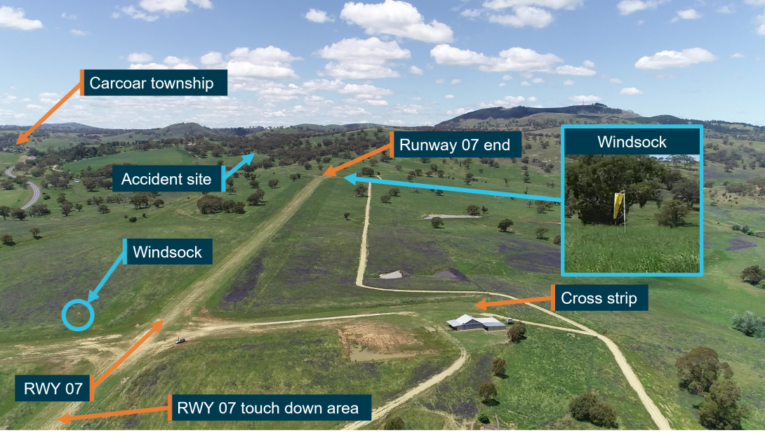
Imaging showing a grass runway. Labels show location of the accident site, cross strip, touch down area of runway 07 and Carcoar township.
Source: ATSB
Information about Coombing Park ALA was available in the OzRunways application. This application was installed on the flight instructor’s mobile phone and was in use during the flight. At the time of the accident, the application had an additional ‘remarks’ section for Coombing Park that included:
Bird and animal hazard exist.
Rising terrain east of field.
No other procedures were included in this guide, nor were they required by any regulations. However, following the accident on 12 November 2020, additional information about Coombing Park ALA was included in the OzRunways application. The ‘remarks’ section was updated to include:
Rising terrain to East, crosswind departures from [runway] 07 only
Terrain at 3,953 within 3NM of field.
No go around on [runway] 07
Power lines at end of [runway] 25
Additionally, ‘procedures’ were added to the OzRunways application in the same update that included:
RH circuits on runway 07
Crosswind departures from [runway] 07
Up wind departures from [runway] 07 prohibited
Simulated engine failures prohibited
Engine failure on [runway] 07: make RH turn and glide to creek flat
Coombing Park ALA was not included in the Enroute Supplement Australia (ERSA).
Meteorological information
Weather information used by the pilots
Documents onboard the aircraft indicated that the student prepared a location briefing, including weather information, at 1304 using NAIPS. This briefing included a graphical area forecast (GAF)[7] for the planned area of operations, aerodrome forecasts (TAFs) and reported observations (METARs)[8]. TAFs and METARs were obtained for Bankstown and Young Airports, and METARs for Cowra Airport. Young Airport was located approximately 35 km from the originally‑planned waypoint near Greenethorpe Township. QNH[9] was also requested for the area of operations and was predicted to be 1014 for the duration of the flight.
The forecasts obtained by the student (TAFs and GAF) covered the duration of the planned flight. The TAF released at 1226 for Young Airport contained predictions for CAVOK[10] conditions. Surface winds were forecast at 12 kt from a westerly direction 290° (True), with the temperature ranging from 26‑28 °C. The GAF issued at 0924, and found onboard the aircraft, predicted visibility greater than 10 km and no significant cloud or weather phenomena for the duration and planned area of flight.
Post‑accident weather analysis
GAFs for the area of operations, TAFs and METARs for Bathurst and Orange Airports, and METARs for Cowra Airport were obtained from the Bureau of Meteorology (BoM) covering the duration of the flight. Although not requested by the student, the TAF released at 1234 for Orange Airport predicted similar operational conditions to Young. These were CAVOK, with similar surface winds at 10 kt also from a westerly direction (260° True), with a temperature of 22 °C. All forecast conditions evaluated predicted suitable weather conditions for flight under the visual flight rules.
Observed conditions at Orange Airport during circuits
The METAR for Orange Airport released at 1500, 4 minutes after OIS arrived, indicated similar conditions to those predicted by the TAF released at 1234. Visibility was greater than 10 km with no cloud detected, and surface winds were reported at 10 kt from a westerly direction (250° True), and a temperature of 24 °C and QNH 1016. Similar conditions were reported in the METAR released at 0530, 7 minutes prior to the departure of OIS from Orange. However, the wind direction changed to a south‑westerly direction (210° True) at 10 kt, with the temperature dropping to 23 °C and QNH 1015.
Estimated conditions on arrival at Coombing Park
Weather observations from Bathurst, Orange and Cowra Airports were used by the ATSB and the Bureau of Meteorology (BoM) to estimate conditions at Coombing Park ALA at the time of the accident (1709). These were the nearest aviation meteorological sites surrounding the ALA, with Cowra Airport being 50 km to the south-west, Orange Airport being 28 km north and Bathurst being 55 km to the north-east.
All METARs released at 1700 for these locations showed visibility greater than 10 km and no cloud detected, consistent with eye-witness reports from the time of the accident. QNH was recorded in METARs as 1011 at Cowra, 1015 at Orange, and 1014 at Bathurst, and was estimated as 1015 for Coombing Park, being closest to Orange. Temperature in the same METARs was 29 °C at Cowra, 23 °C at Orange and 25 °C at Bathurst, and was estimated as 24 °C at Coombing Park, based on the aerodrome elevation and proximity to Orange.
Surface wind analysis
The BoM conducted an analysis of surface winds at the accident site based on the surface winds reported in 1-minute intervals at Cowra, Orange, and Bathurst. BoM estimated a surface wind direction of westerly though north-westerly, with an estimated wind speed of 5‑10 kt, possibly up to 15 kt. Surface wind gusts were not expected to exceed 5‑15 kt, although gusts up to 20 kt were possible, consistent with observed wind gusts at Cowra, Orange and Bathurst. Based on this analysis, if the wind was north-westerly, the mean tailwind component on runway 07 was estimated between 3‑6 kt, gusting up to 13 kt.
If the wind was from a westerly direction, the mean tailwind component was estimated between 5‑10 kt and gusting up to 20 kt. The crosswind component would have likely ranged between 2‑8 kt from the left of OIS, and possible crosswind gusts up to 15 kt. Based on the runway direction, BoM reported that it was unlikely that there was a headwind component to the surface wind over the runway at the time of the accident.
Estimation of tailwind
The ATSB also estimated the tailwind component on runway 07, based on the groundspeed of OIS during approach to land. Flight data indicated that the ground speed on late final approach of OIS was about 67 kt. Based on a recommended approach indicated airspeed of 60 kt, as required by the AFM for OIS, the nil wind ground speed or true airspeed at the elevation of Coombing Park for this indicated airspeed was calculated as 62.3 kt. Based on this, the mean tailwind component was estimated to be 5 kt, within the bounds of the probable wind speed provided by the BoM.
Aircraft performance information
Touch-and-go information
Data for the accident flight showed that, following the 2 left precautionary search patterns around Coombing Park ALA, the aircraft flew parallel to the main runway (corresponding to the left downwind leg for runway 07) before a left descending turn was conducted (base leg). At the completion of this turn the aircraft was slightly right of the runway 07 centreline, approximately 1,200 m horizontally from, and 300 ft above, the runway threshold. The approach flight path indicated that a slight left tracking correction was likely performed to align the aircraft with runway 07. An eye-witness, who was a pilot familiar with the strip and situated approximately 300 m to the west of the runway 07 threshold reported that the aircraft flew about 40 ft above the trees in a very flat, low and slow approach.
The eye-witness also reported that the approach appeared to be smooth, well configured and balanced, to have lots of flap out, with the engine sounding normal. At the time the aircraft flew past, the runway was not visible to the eye-witness due to the vantage point being slightly below the runway threshold. However, the eye-witness recalled stating to a friend that they hoped the aircraft didn’t land short of the strip when observing the approach. The eye-witness expected that the aircraft would have touched down ‘right near’ the runway 07 threshold, based on the flight path and slow airspeed observed. There were no witness marks identified by the ATSB on the runway surface that were indicative of a hard or abnormal landing. The touch down area for runway 07 (Figure 5) was slightly less grassed than other parts of the runway, consistent with normal landings in that area, no marks were found that could be attributed to the touch-and-go.
ATSB evaluation of flight data along the runway strip showed that the previously‑observed descent rate during the approach was no longer discernible shortly after the aircraft crossed the runway 07 threshold. However, it was not possible to identify the exact position of touch down due to the precision of this data. This data also indicated that the aircraft crossed the runway threshold at a ground speed of approximately 60 kt, with the aircraft beginning to reduce speed about 5 seconds after this point. Within about 10 seconds, the groundspeed reduced to a minimum speed of about 44 kt approximately 400 m past the runway threshold. The flight data then indicated that OIS began to accelerate, consistent with application of engine power by the pilots. ATSB evaluation of flight data estimated that lift-off and climb to 50 ft likely occurred approximately 929 m from the runway 07 threshold, attaining a stable ground speed of about 63 kt during the initial climb.
Evaluation of touch‑and‑go length
The ATSB performed a comparative analysis between the length (distance from the runway threshold to the take‑off point) of the touch-and-go at Coombing Park compared to the length of 4 touch-and-go landings and the standing take-off conducted at Orange Airport. The purpose of the analysis was to identify any factors that may have increased the length of the touch-and-go at the ALA. Further detail on this analysis, including methodology, additional context and findings of this analysis are described in Appendix A – The influence of touch‑and‑goes to the accident involving VH-OIS, 4 November 2020. A summary of the findings from this analysis are as follows.
The length of the Coombing Park ALA touch-and-go was the third shortest of the flight. The two shortest touch‑and‑go landings conducted at Orange at 1602 and 1615 had lengths of just over 750 m. The fourth shortest touch‑and‑go was conducted at Orange at 1556 (the first approach) and had a length of about 1,000 m.
The ATSB applied corrections for aircraft mass, density altitude and surface type to estimate the length of the Coombing Park touch‑and‑go if it had been conducted at Orange (the corrected touch‑and‑go). The purpose of this correction was to allow a direct comparison between the Coombing Park touch-and-go and all take-offs conducted at Orange. The corrected touch‑and‑go was estimated to have a length between 812 m (with a 25% factor applied for dry grass) and 1,015 m (no grass strip correction) (as stated above the actual length was 929 m). Based on these estimations, it is likely that if the Coombing Park touch‑and‑go had been conducted in the same way at Orange Airport, the length would have been in the same ranked order (that is, third shortest).
The ATSB also evaluated the potential effect of OIS performing a standing take-off instead of the touch‑and‑go at Coombing Park under the same conditions, and this is also detailed in Appendix A.
From this analysis, the standing take-off length at Coombing Park was estimated to be between 630 and 836 m. The estimated zone along Coombing Park runway 07 where OIS would have climbed to 50 ft from a standing take-off is shown in pink in Figure 6. This figure also shows the location of the start of runway 07, the actual take-off for OIS, the upwind track in red-dashed lines, and an indicative track for the start of the left turn. The reference tree is shown for continuity between figures in this report.
Figure 6: Upwind track of OIS following touch‑and‑go at Coombing Park ALA, (view looking south-west)
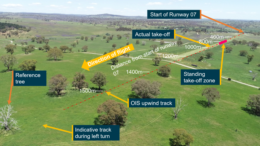
Image showing upwind track of OIS (red dashed lines), actual take-off position of OIS and estimated take-off zone if a standing take-off was conducted
Source: ATSB
Guidance for determining touch‑and‑go length
There were no details for the calculation of touch‑and‑go length in the aircraft flight manual (AFM), nor were these required. Research by the ATSB identified a limited number of guidance publications for the calculation of a suitable runway length for a touch‑and‑go. Two articles were identified that presented anecdotal techniques for the calculation of required runway length for a touch‑and‑go. As context to the challenges associated with a touch‑and‑go in an article by Aviation Safety magazine, Burnside (2019) stated:
The principal challenge posed by the touch‑and‑go manoeuvre is managing the immediate transition from a landing to a take-off, presenting that touch‑and‑goes are more complicated than just stringing together a landing with a take-off.
Further, in an article released by the Aircraft Owners and Pilots Association (AOPA), Wright (2006) identified some of the challenges that may be encountered by a pilot during a touch‑and‑go after the aircraft has landed:
Once power is added, the pilot is now concerned with achieving a normal take-off rotation speed while ensuring that there is sufficient runway to safely clear any obstacles. Somewhere in all of this there must be a verification that the flaps really did retract, the engine instruments are giving normal readings, and all required checklist items are accomplished.
At some undefined point, the landing roll ends, and the take-off roll begins. If the runway is relatively short, it may leave you with little to no room to execute a safe rejected take-off. Likewise, floating too long during the landing or being slow in retracting flaps may bring on the same situation.
The articles by Wright (2006) and Burnside (2019) each presented a method to estimate a safe length for a touch‑and‑go to be conducted. Wright (2006) stated:
A good rule of thumb is to take the landing distance over a 50-foot obstacle and the take-off distance over a 50-foot obstacle, add them, and double (or triple) the result to get a minimum runway length.
Burnside (2019) provided a sample calculation based on 3 elements. In summary, this sample calculation involved calculating:
- The average of the landing roll and landing distance required to clear a 50-foot obstacle;
- the time on the ground to reconfigure the aircraft, and;
- the average of the take-off ground roll and take-off distance required.
In this article, Burnside (2019) identified several reasons to be more conservative than this, citing that pilot technique, a less than perfect engine, a dragging brake or a crosswind requiring drag-producing aileron input can change those numbers.
Significantly, both methods estimated that a touch-and-go length used more runway than a standing take‑off. Additionally, the analysis conducted by the ATSB also identified that all touch-and-go manoeuvres conducted by the student were likely to use more runway than a standing take-off.
Specifically, when corrected for density altitude, a standing take-off length at Coombing Park ALA was estimated by the ATSB to be between 630‑836 m for the atmospheric and weather conditions at the time of the accident, notably shorter than the actual Coombing Park ALA touch‑and‑go length of 929 m.
Initial climb performance
The ATSB evaluated the potential influence of a standing take-off on the height of OIS during the initial climb. The analysis indicated the relative height difference if a standing take-off was conducted instead of the actual touch-and-go. The climb profiles are projected in straight lines, along an extended upwind track, although these results also indicated the relative differences between a standing take-off and the touch-and-go on curved flight paths. The distance from the start of Coombing Park ALA runway 07 was used as the datum for the analysis, and this is shown on the horizontal axis of Figure 7. For reference, these distance markers are reproduced over an image of the runway area in Figure 6 and the upwind area in Figure 9.
This analysis used the estimated standing take-off distances described in the section above and is illustrated in Figure 7. The vertical axis shows the height above the estimated point of lift off and the horizontal axis shows the distance from the start of runway 07 at Coombing Park ALA, and also corresponds to the markers shown in Figure 6.
Terrain elevation is shown by the solid dark green area, with typical tree heights indicated by the translucent dark green (minimum 33 ft (10 m)) and light green (maximum 66 ft (20 m)) areas.
Figure 7: Height of initial climb profile for OIS at Coombing Park ALA, including estimations for climb profiles following standing take-off and estimated terrain profile
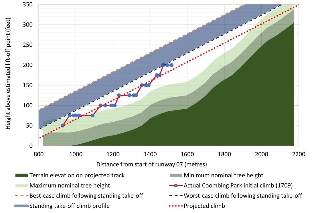
Figure showing plot of height vs distance travelled of OIS during the initial climb from Coombing Park ALA runway 07 compared to terrain and estimates for climb if a standing take-off was conducted.
Source: ATSB
The actual initial climb profile of OIS conducted at 1709 is shown in Figure 7 by the series with red lines and blue circles. The last data point of this series indicates the relative height of OIS immediately prior to the left turn. The red dotted series is the line of best fit for the 1709 initial climb and shows an estimated projection of the climb if the climb rate was maintained and OIS tracked in a straight line instead of turning left. The top right corner of Figure 7 shows the projected climb passing within about 45 ft (14 m) of the terrain, below the maximum nominal height.
The likely climb profiles following theoretical standing take-offs at Coombing Park ALA are shown by the blue band (labelled ‘Standing take-off climb profile’ in Figure 7). The standing take-off climb estimates show the result of translating the actual climb of OIS at 1709 to start from take-off locations of theoretical standing take-offs at Coombing Park ALA, as described in the section ‘Estimation of standing take-off distances’ in Appendix A.
The dashed lines above and below the blue band represent the limits of the analysis, with the best-case shown in orange and the worst-case shown in dark blue. The best-case scenario is derived from the shortest theoretical standing take-off (630 m), and the worst-case is derived from the longest theoretical standing take-off (836 m), as described above. The top right corner of Figure 7 shows all climbs following hypothetical standing take-offs as passing close to, but above the maximum nominal tree height at the local terrain peak, with the worst case projected to pass within about 67 ft of the terrain.
The best- and worst-case standing take-off estimates equated to OIS being between 22‑70 ft higher at each point during the initial climb if a standing take-off was conducted instead of a touch‑and-go, as shown by the height differences between these lines and the dotted red-line in Figure 7. In contrast to the initial climb after the actual touch-and-go projecting below the maximum tree height, climb projections from standing take-off estimates indicated that OIS would pass close to, but slightly above the maximum nominal tree height had an upwind departure been conducted. Further climb performance analysis for curved flight paths are discussed in the section titled Turn and final track information below.
Initial climb gradient
At the time of the accident, flight planning legislation required pilots to plan to take-off with the aircraft weight sufficiently low to allow the aircraft to achieve a minimum climb gradient. This was stipulated in paragraph 7.1 of Civil Aviation Order 20.7.4, which stated:
In the take-off configuration with landing gear extended, an aeroplane must have the ability to achieve a climb gradient of 6% at take-off safety speed, without ground effect, and with all engines operating at take-off power.
Based on flight data, the ATSB calculated the climb gradient of OIS during the initial climb from Coombing Park to be just over 7%. This was based on the flight data for OIS between 50 ft and 200 ft above the lift-off point (shown by the red line with blue circles in Figure 7). OIS was very likely outside ground effect for this segment of the flight. Further, the climb gradient of OIS was typical of climbs performed earlier in the flight at Orange.
Initial climb rate
The ATSB evaluated the climb rate of OIS after take-off from Coombing Park compared to climbs after take-offs at Orange Airport, earlier in the flight. Climbs after take-off were evaluated from 50 ft above the surface, to reduce uncertainty associated with the transition from the ground roll to a stable climb, including ground effect. Corrections for density altitude were performed on the climbs at Orange (increasing the actual values by 3.6%) to compare with the Coombing Park initial climb which had a lower elevation. Figure 8 shows the results of this comparison.
Figure 8: Climb rate of OIS after take-off at Coombing Park ALA, and climb rate for OIS at Orange Airport corrected for density altitude at Coombing Park ALA, 4 November 2020
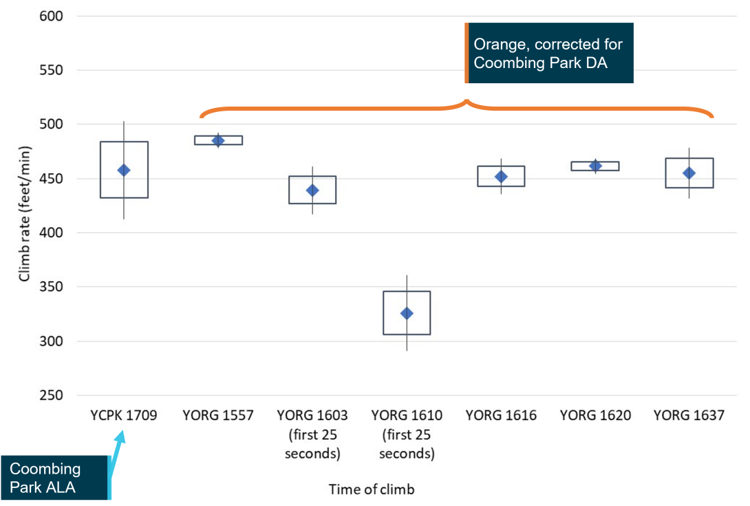
Chart showing comparisons between initial climbs conducted at different times during the flight
Source: ATSB
The blue diamonds in Figure 8 show the mean climb rate calculated for each climb away from the runway, indicated in ft per minute by the vertical axis, with labels on the horizontal axis indicating the local time that each climb was commenced. The height of the boxes and vertical lines around the mean illustrate uncertainty in the rate of climb, with the boxes indicating where the mean climb rate likely existed, and vertical lines (whiskers) indicating where the mean climb rate very likely existed.[11], [12], [13]
The left most data point labelled ‘YCPK 1709’ shows a mean climb rate of about 460 ft per minute during the straight component of the initial climb from Coombing Park runway 07. This rate was comparable to the initial climbs conducted in OIS at Orange at 1603, 1616, 1620 and 1637. The considerably lower initial climb rate at 1610 is consistent with an aborted landing being conducted with full flaps extended, a planned exercise as part of the CPL assessment.
Based on the AFM for OIS applied to the observed conditions at Coombing Park ALA, the best rate of climb was 580 ft per minute. The best rate of climb in the AFM is calculated based on test flights conducted under normal operating conditions, typically using a new aircraft and engine, with the aircraft flown in an optimal configuration. For this reason, it is not expected that OIS would have achieved the published climb rate in the AFM. Due to the damage to OIS, it was not possible to perform further assessments to establish why the rate of climb differed between OIS and the expected rate of climb in the AFM. However, it should be noted that the examination of the wreckage by the ATSB did not reveal any mechanical faults or defects with OIS, as described in the section titled Wreckage and accident site information.
In summary, flight data analysis conducted by the ATSB identified that the climb performance of OIS during the initial climb at Coombing Park ALA was comparable to climbs conducted at Orange Airport earlier in the flight.
Turn and final track information
Flight data indicated that immediately prior to turning left, OIS was approximately 125 ft above the ground (Figure 7), tracking toward steeper terrain with a significant number of trees. Figure 9 shows an image facing in a similar direction and at a similar height to the pilots just prior to where the left turn was initiated. The projected upwind track with distance markers shows the rising terrain corresponding to the elevation profile shown in Figure 7, with the same reference tree as shown in Figure 6. The projected upwind track provides a relative guide for analysis of climb performance covered in other section and does not necessarily indicate the intended track of OIS.
Figure 9: Image looking uphill at a similar height and position to OIS immediately prior to left turn
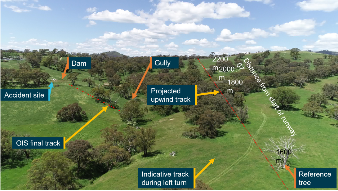
Image showing upwind track of OIS, approximate track during left turn and projected track if OIS continued in a straight line
Source: ATSB
Figure 10 shows a top-down image of the upwind area of runway 07 for Coombing Park ALA. This shows the entire track of OIS in red lines with blue circles, including the initial upwind track for the climb profile in shown in Figure 7. For reference, common labels such as the distance markers and reference tree are included in Figure 6, Figure 7 and Figure 9.
Figure 10: Image looking down on upwind area of Coombing Park runway 07 showing track of OIS and accident site
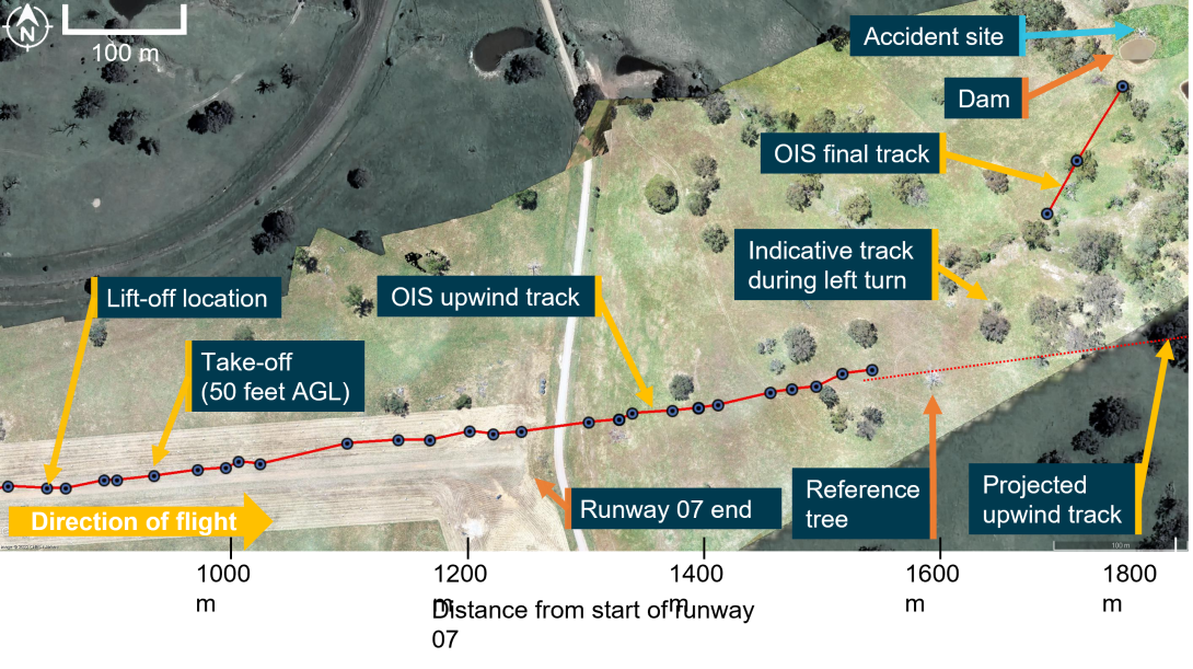
Down-looking image of runway 07 end of Coombing Park ALA and flight track of OIS
Source: Google Earth, with image overlay and annotations by ATSB
An indicative track of the left turn and final track of OIS is also shown in Figure 10. Flight data indicated that as OIS approached a line of trees, the track changed by about 50° to the left in less than 7 seconds, corresponding to a turn rate of more than 450° per minute. The radius of the turn was estimated to be about 185 m, with an angle of bank calculated as 22°.
Compared to other climbing turns conducted during the flight, the turn rate was almost twice as high, and the bank angle was at least 60% steeper. During the turn, OIS continued to climb, although at a reduced rate, gaining about 25 ft by the completion of the turn, with the mean groundspeed decreasing slightly.
The ATSB conducted a climb performance analysis to evaluate 3 hypothetical ‘escape’ scenarios for OIS:
- continuing the left turn,
- turning right instead of turning left, or
- ceasing the left turn half-way through and flying straight up the gully (shown in Figure 9).
This involved projecting a climb profile over the terrain elevation map based on Google Earth and the estimated height of surrounding trees. Based on this evaluation, the hypothetical flight profiles for the left and right turns both passed within about 66 ft (20 m) of the ground. This was a similar height to the trees in the area.
The flight up the gully was estimated to pass within about 72 ft (22 m) of the ground. Although this was marginally higher than the trees in the area, due to uncertainty in the data, it was not possible to determine if OIS would have been able to climb away in this scenario.
Flight data and onsite measurements indicated that following the left turn, the height of OIS is likely to have been similar to the canopy height of surrounding trees for the third- and second-last data points, although the precise height could not be determined. Beyond the tree close to the flight path (shown in Figure 11), projections indicated that if the climb rate was restored after the turn and OIS had cleared this tree, the aircraft would have passed within 66 ft (20 m) of the ground in the rising terrain beyond the dam at a similar height to trees in the area.
The last 3 flight data points indicated that the ground speed of OIS likely increased, with OIS travelling approximately 110 metres in 3.2 seconds between these 3 points. OIS likely descended by at least 25 ft, possibly by 50 ft between the last 2 flight data points. This was likely to the left of and below the canopy of the tree close to the flight path. Approximately 1 second after the last flight data point, OIS collided with the embankment on the far side of the dam at a similar height.
Wreckage and accident site information
Accident site
The accident site was located on private property about 38 km south of Orange township and 27 km south of Orange Airport (Figure 1). This property was adjacent to Coombing Park ALA, with OIS located about 600 m from the end of runway 07, and about 300 m left of the extended runway centreline (Figure 3).
Wreckage examination
Site and wreckage examination did not identify any aircraft defects or anomalies that might have contributed to the accident. Examination of the area surrounding the accident site, including the tree close to the likely flight path (labelled), did not identify any trees or terrain that might have been struck by OIS prior to the wreckage location (Figure 11).
Figure 11: Image looking down on accident site and surrounding trees viewed from the direction of travel
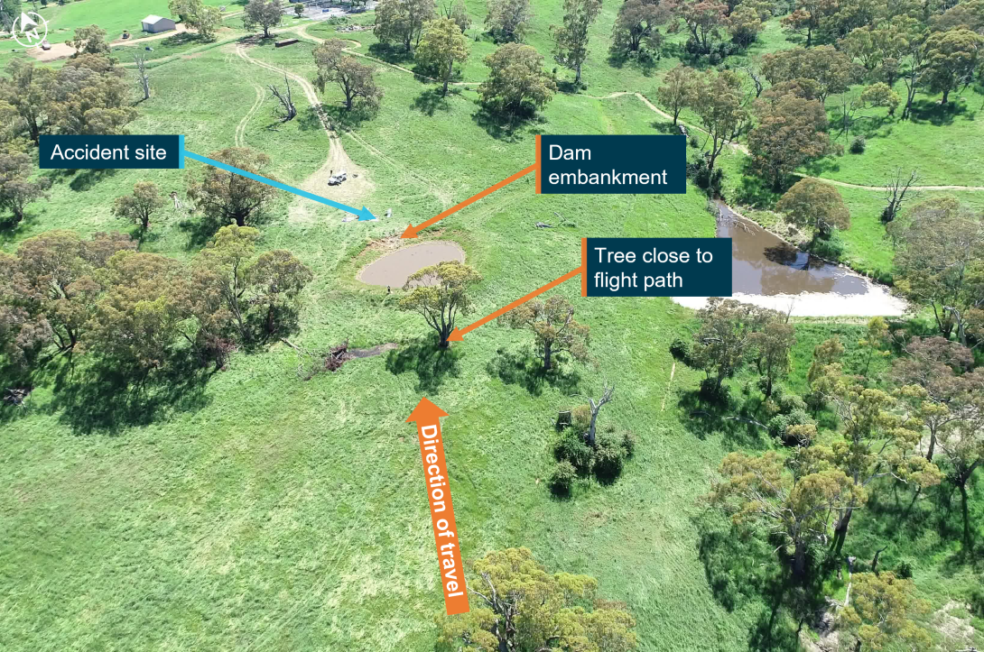
Image showing accident site and surrounding trees
Source: ATSB
The aircraft struck the embankment of a small dam in an upright attitude. Flight data and ground scars marks indicated that OIS was tracking in a generally northerly direction at the time of the collision with terrain. The accident site was located slightly to the left of the projected track, with propeller strike marks indicating that the nose of the aircraft was pointed to the left of this track around the time of the collision. During the collision, the aircraft rotated in a counter-clockwise direction, coming to rest facing toward the south-south‑west, about 180° to the direction of travel.
The damage to OIS was consistent with significant upward and rearward forces being transferred through the aircraft structure during the collision. The left wing and left-wing flight controls, aircraft canopy, cockpit area, nose landing gear, engine cowling, propeller and tail section of the aircraft were severely disrupted by impact forces. The counterclockwise rotation during the collision was likely induced by the left side of the aircraft (mostly from the left wing that was completely destroyed) colliding with the dam embankment prior to the right side of the aircraft.
Engine and propeller
The engine assembly was examined and found to be complete with no evidence of pre-accident engine control problems or defects. The inspection found all engine controls were connected from the cockpit controls through to the engine, with all electrical wiring and hoses connected.
Both propeller blades fractured and separated from the propeller hub during the collision. Both tips of the propeller blades were located at the accident site. No evidence of pre-accident damage was identified in the propeller blades, propeller hub or propeller hub attachment to the engine crankshaft. The propellers broke into multiple fragments, and most fragments were located at the accident site. However, one large portion of blade was located about 27 m to the east of the site, consistent with this portion breaking away and being thrown through the air during the impact sequence.
Fuel
OIS was fully fuelled immediately prior to departure from Bankstown Airport and had sufficient fuel to conduct the flight. An onsite inspection identified that both the left- and right-wing fuel tanks were compromised with no fuel being identified in these tanks. Fuel was identified in both carburettor bowls and was found to be clear of contaminants, including water.
Emergency locator transmitter
OIS was fitted with an emergency locator transmitter that activated automatically during the accident sequence. This was deactivated by the ATSB onsite. The signal from the ELT was not received by emergency services, likely due to damage sustained to the antenna during the accident.
Flight controls
Flight controls were examined to the extent permitted by impact damage. Nothing was identified in the wreckage with respect to a flight control defect or malfunction that may have contributed to the accident. Complete continuity of flight controls from the cockpit to the control surface was established for the right-wing aileron, flaps, elevator, rudder, and elevator trim. The elevator trim position was unable to be established.
Continuity of the left-wing aileron and flaps was partially established from the cockpit to the control surface attachment brackets. Push rods and bell cranks associated with the wing mounts of these control surfaces were detached from the left wing during the collision, however, no pre‑existing defects were identified in these components.
The flaps were separated from the flap control actuator during the collision. The flap control actuator included a screw jack with the function of moving and holding the flaps in a fixed position. The extension of the screw jack had a corresponding flap position in the normally functioning aircraft. The ATSB was advised by the aircraft manufacturer that the measurement on the screw jack extension corresponded with the flaps being fully retracted.
Precautionary search information
A precautionary search and landing is a procedure for conducting a safe, powered landing away from an airport or ALA with known suitable landing surface conditions. It is normally conducted for two reasons:
- A landing on an unprepared landing surface made necessary due to an abnormal or emergency situation, such as deteriorating weather, insufficient remaining daylight, fuel shortage, technical problems, developing medical conditions or any other reason determined by a pilot
- A pre-planned landing when the pilot is unfamiliar with the landing area, or its condition is unknown.
Soar operations manual
Procedures at Soar were governed by an operations manual, as required by Civil Aviation Safety Regulation Part 141, regulation 141.260. This manual was available for use by flight instructors through an online portal. Version 2.5, published on 2 April 2020, was the most current version of the operations manual at the time of the accident. This operations manual was developed from the CASA sample operations manual version 2.1 dated October 2016. All relevant text cited in this report is common between the Soar Operation’s manual and the CASA sample operations manual.
Criteria for the assessment of the precautionary search
The purpose and importance of a pilot demonstrating the ability to conduct a safe precautionary search was stated in paragraph 11.1.3 of Advisory Circular 91-02[14]:
The ability to accurately assess the prevailing environmental conditions, potential obstacles, surface conditions, dimensions and ultimate suitability of a landing area, will be enhanced by using a well‑practiced procedure to maximise the likelihood of a safe landing outcome.
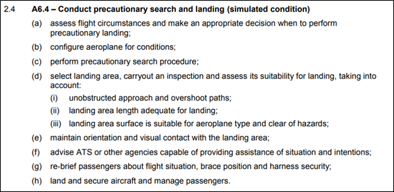
Clause 3.4(f) of Schedule 5 ‘Flight test standards’ in Part 61 Manual of Standards (MOS) page 586 dated 11 December 2018 noted that a precautionary search was required as part of the test specific activities and manoeuvres in the commercial pilot licence (CPL) flight test and was therefore also to be covered in the pre-CPL flight test. Further, Soar’s operations manual stated that the CASA standard syllabus, lesson plans and planning matrices would be used for the schools training courses.
A ‘flight test report’ form (described in the section ‘Assessment plan for the CPL flight test’ on page 24) was used by the instructor to assess CPL competency during the flight. This form included item 3.4(f) labelled ‘Conduct precautionary search’ under the section ‘Test specific activities and manoeuvres. A reference to MOS A6.4 was included for this item, and this is reproduced in Figure 12. No assessment notes were recorded against this, or other items of this section of the form.
Figure 12: Extract from Schedule 2 ‘Competency Standards’ of Part 61 Manual of Standards dated 24/09/2018 page 126
Precautionary search height
The importance of the height selection for inspection runs during a precautionary search was articulated in the following paragraph 11.1.4 from Advisory Circular AC 91-0213:
It will be particularly important to consider appropriate heights to be able to conduct such a procedure safely, while remaining cognisant of potential engine failure considerations, especially if the requirement for a precautionary procedure was initially necessitated by an aircraft malfunction, low fuel state, or other related issue.
Further, for the inspection of the proposed landing path, page 59 the CASA Flight Instructor Manual (FIM)[15] stated:
This preliminary inspection should be sufficiently low for the surface to be inspected but not so low that it is necessary to avoid obstacles. Another point to impress on the student is that the inspection runs should be made at a constant height whilst safely avoiding upwind obstacles. If not satisfied with the surface complete at least one other inspection run at a lower height if necessary.
Further the FIM stated:
The need for a really good lookout whilst carrying out this low flying exercise cannot be over‑emphasised.
And
This exercise should be practiced only in approved areas or at approved fields and even then, all effort should be made to avoid frightening livestock and annoying people.
Inspection heights flown by OIS
During each circuit pattern the altitude of OIS varied, with flight data indicating that the pilots descended OIS during the southerly and easterly pattern legs before returning to a nominal height between 1,000 and 1,100 ft AGL. Based on the Soar guidance to instructors for use when conducting training exercises (referred to as patter notes), the inspection pass would have been the easterly facing leg of each circuit pattern (Figure 3). Each eastern facing leg was flown just over 1 km from the centreline of runway 07. Based on flight data for OIS, each inspection pass was flown at the following heights:
- Pattern 1 (Figure 3 yellow lines): OIS descended to a minimum height of 750 ft AGL, and 400 ft above the ridge on the extended centreline for runway 07 (the ridge), during the easterly leg before returning above 1,000 ft AGL.
- Pattern 2 (Figure 3 orange lines): OIS descended to 850 ft AGL (500 ft above the ridge) during the easterly leg before climbing above 1,000 ft AGL for the northern leg and descending throughout the western leg.
- Pattern 3 (Figure 3 red lines): OIS levelled out between 450 and 475 ft AGL (100 to 125 ft above and 3.3 km from the ridge), before commencing a climb just after crossing over the extended centreline of runway 07/25 (start of pattern 3 in Figure 3). OIS continued to climb through the third easterly facing leg from about 500 to a peak height of 1,200 ft AGL mid‑way along the third northern leg. The flight instructor sought permission to conduct a touch‑and‑go from the property manager of Coombing Park ALA at some time along the southerly and/or easterly legs of this pattern.
Guidance in Aircraft flight manual for OIS
Under a section labelled ‘Emergency Procedures’, the AFM for OIS included guidance for the conduct of a precautionary search, stating that the inspection height shown be flown at an altitude above 500 ft. It is expected that this was intended to refer to height instead of altitude.
Section 2A2 of Soar’s operations manual stated ‘Where the Aircraft Flight Manual conflicts with other publications the Aircraft Flight Manual has precedence.’ However, the circumstances described in the AFM related to landing on an un-prepared field and did not include guidance for the conduct of a precautionary search and landing in normal operations or training.
Operator’s guidance
The operator produced guidance for instructors to use when conducting flight training exercises, referred to as ‘Patter Notes’. Under the patter notes for the demonstration of a precautionary search and landing, a series of 3 circuits were described, each with different heights to be flown. Each circuit was to be conducted at a nominated circuit height, with a descent during final approach to progressively lower heights for each circuit. The third circuit was listed as ‘only conducted if still uncertain about field conditions. After each circuit, the guidance suggested a climb back to the nominated circuit height.
The heights were listed in the patter notes as follows:
- Circuit height (every circuit): 1000 feet AGL ([to] simulate [
dan actual height of] 500 feet AGL) - First inspection pass: 1000 feet AGL ([to] simulate [
dan actual height of] 500 feet AGL) - Second inspection pass: 700 feet AGL ([to] simulate [
dan actual height of] 200 feet AGL) - Third inspection pass: 550 feet AGL ([to] simulate [
dan actual height of] 50 feet AGL)
For each circuit, 2 sets of heights were presented, a higher, simulated set for the purpose of an exercise over an unprepared field (figures shown outside brackets above), and the other set relating to the actual heights to be flown for an effective inspection (shown within brackets). For example, the simulated height of the second inspection pass was 700 ft AGL, with the actual height listed in brackets as ‘simulated 200 feet AGL’. At the completion of the third circuit the guidance stated:
Turning final go around (if at an ALA or aerodrome, conduct short field landing).
In the event of a real prec search, short field landing, full stop landing. Do not taxi prior to walking the field.
At the conclusion of the precautionary search guidance, the patter notes stated:
Note: if conducting PSL at an ALA or aerodrome, actual heights may be used.
The ‘actual heights’ referred to are those listed inside the brackets above.
Other guidance
Guidance relating to the assessment of overshoot areas and the recommended heights that this assessment should be flown are included in various sources. However, the minimum height recommended for the conduct of an inspection run varied. Page 61 of the CASA FIM provided detail for the conduct of an air exercise by a flight instructor to demonstrate a practiced precautionary search and landing:
When in a suitable area descend to about 500FT above the ground and tell the student to assume poor weather conditions with a cloud base of about 600FT and poor visibility. Choose a suitable airstrip and demonstrate how to inspect the surface. Fly at low safe cruising speed with the optimum flap setting. Fly over the field slightly to the right of the intended landing path at about 100FT to make the first check. On this run check the surface and drift and note any high ground and obstacles in the overshoot area.
In ‘A pilot’s guide to safe flying’[16], for a precautionary landing procedure, this guide includes:
Confirm the acceptability of the landing area by carrying out an inspection run at 200 feet AGL (or well above possible obstructions), into wind, and slightly to the right of the intended landing area. Check out the following:
- …
- Obstacles, both on approach, and possible overshoot.
- …
Guidance was also produced by the New Zealand Civil Aviation Authority[17]. For the first circuit, the guidance for the focus during the inspection includes:
On this and subsequent legs, …, with particular emphasis on surrounds in the approach and climb-out areas.
Guidance for a second inspection run stated:
Assuming the chosen landing site appears suitable up to this point, a second inspection is carried out at a minimum of 200 feet AGL.
…
Established on and parallel to final, a gradual descent to a minimum of 200 feet AGL is carried out.
Descent below 200 feet AGL is not recommended, because it takes considerable concentration to fly the aeroplane level and look at the landing site surface. Also, there is a possibility of unseen obstructions, and since a climb to 500 feet AGL will be initiated on completion of this inspection, the climb is minimised. Unless committed to the landing, never descend below the highest obstacle in the go-around path.
Selection of take-off and landing direction
Influence of wind
Pilots are required to choose the most suitable direction for landing and take-off when operating at any aerodrome. Generally, the main factor for this decision relates to the wind strength and direction. On a flat runway, a take-off or landing into wind (a headwind) will reduce the distance required in each case, whereas a tailwind will increase the distance required. For OIS, performance charts indicated that a tailwind component of 1 kt would lead to increases to the landing and take-off distances between 2.5‑2.8%. This equates to about 12 metres for the ground roll and a further 12 metres to clear a 50 ft obstacle per 1 kt of tailwind.
Influence of runway slope
In a section titled ‘Inclined runways’, Geeting and Woerner (1988)[18] stated:
Where possible, plan upslope landings and downslope take-offs.
This is because conducting a landing on a runway with an uphill slope reduces the landing distance required, whereas a take-off on an uphill slope increases the required take-off distance. An extract from guidance about Coombing Park ALA in the OzRunways applications described that the ‘airfield follows ground contour, rising to the east’. OIS conducted the touch-and-go in an easterly direction at Coombing Park ALA (runway 07).
For the landing component of the touch-and-go conducted by OIS, the tailwind condition (as described in the section titled Post accident weather analysis) and slight uphill runway slope had opposing effects on the landing distance. Estimations performed by the ATSB indicated that the deceleration advantage provided by an uphill landing at Coombing Park ALA was in a comparable range to the disadvantage provided by the tailwind.
The tailwind component was probably relatively low, based on the climb gradient of OIS being comparable to earlier climbs, and the pilots likely assessing the wind strength and direction from the two serviceable windsocks at the ALA. However, due to uncertainty in the actual wind conditions, it was not possible to determine the relative impact that the tailwind and the runway slope had on the touch-and-go length. Therefore, it was not possible to determine which runway direction would have provided the shortest distance for landing at the time of the accident.
During the take‑off phase of the touch-and-go, the tailwind and uphill slope would have both combined to increase the distance for OIS to become airborne. However, the touch-and-go length was comparable to others conducted at Orange earlier in the flight as discussed earlier, and it was again not possible to determine the relative contribution that the tailwind and slope had on the touch-and-go length. Once airborne however, the tailwind component would likely have had an adverse effect on the aeroplane’s climb gradient, although this could not be quantified.
Considerations for use of runway 25
Conducting a touch-and-go on runway 25 would have required the pilots to approach over the rising terrain and trees to the eastern end of the field. This would have required a steeper angle than the approach flown for runway 07, or for the pilots to touchdown part way into the runway. Due to the same uncertainty in the wind strength noted above, it was not possible to determine the length of a touch-and-go on runway 25, and the relative influence of a downhill landing or the headwind components.
The ATSB also considered the effect of conducting a standing take-off from each runway. For take-off on an inclined runway, Geeting and Woerner (1988)17 stated:
Always take-off downhill in light wind conditions. Acceleration is greater, less runway is required, and obstacles are cleared more easily. During take-off, a 1° downslope is roughly equivalent to having 10% more runway; a 2.5° upslope is equivalent to having a 7 kt tailwind during take-off.
For the take-off of OIS on runway 07, the tailwind conditions and uphill runway slope would have increased the distance required compared to a take‑off conducted on runway 25. Additionally, the final approach gradient of OIS to runway 07 was estimated to be about 6.5%, shallower than the climb-out gradient of about 7%.
Significantly, this indicated that OIS would likely have cleared all obstacles and terrain after a standing take-off from runway 25.
Operational information
Commercial pilot licence flight test assessment plan
Section 3D1 of the operations manual titled ‘Training Plans and Syllabuses’ stated:
Soar Advanced Flight Training has elected to use standard syllabuses, lesson plans and planning matrices prepared by CASA. These syllabuses are reproduced IAW those listed in Volume 5. In designing various courses, the school may vary the lesson times or add lessons in the syllabuses as required to be consistent with the training course in use.
This is consistent with interviews with instructors who stated that the CPL syllabus followed the requirements of Part 61 of the Manual of Standards.
Section 5A2.3 of the operations manual titled ‘Assessment plan’ stated.
A student may be deemed competent to conduct a solo flight, be recommended for a flight test or issued a qualification when competency is demonstrated on at least two occasions (each occasion being on a separate flight). Pre-solo and end of course assessments have been planned on this basis. End of course assessments take into account all of the units of competency mentioned in the Part 61 MOS for the licence, rating or endorsement.
Based on previous flights, this flight would have constituted the first of two pre-CPL flight assessments for the student. All units of competency mentioned in the Part 61 MOS for the commercial pilot licence would apply. This was consistent with a partially completed ‘Flight Test Report’ form 61-1490 found onboard the aircraft. Based on this, the assessment was to include diversions, aborted landings, practiced forced landings, short-field and flapless landings, and precautionary searches. Based on flight data for OIS, these exercises appear to have been performed during the accident flight.
Pilot roles and responsibilities
For this flight (and other training flights) with the student and instructor onboard, the flight instructor was the pilot-in-command. This is confirmed in section 3B1.17 of the operations manual titled ‘Instructor-student co-ordination’:
The Pilot In Command for dual training flights is the flight instructor. The flight instructor is responsible for ensuring that there is no doubt as to who has physical control of the aircraft at any given time; hence, the hand-over and take-over procedures shall be adopted for all dual training flights.
Further, section 3B1.1 of the operations manual titled ‘Authorisation of training flights’ stipulated: ‘prior to despatching any training flight in a School aircraft, the Pilot in Command is to ensure that they have checked the following:
- …
- changes or restrictions concerning the use of the aerodrome and training area;
- …
Therefore, for this flight, the operations manual confirmed that the flight instructor was expected to check if any restrictions existed with respect to using the Coombing Park ALA for flight training.
Pre-flight information
Purpose of flight
The purpose of the flight was for Soar to assess the competency of the student, prior to the student undertaking the CPL flight test (the pre-CPL assessment). The pre-CPL assessment was required by Soar for every student and acted as a final check to ensure that the student was ready for the actual flight test. Accordingly, the pre-CPL assessment flight was structured to include exercises for the student to demonstrate competency against the CASA CPL syllabus as directed by the flight instructor.
Flight arrangement by student
The pre-CPL assessment flight was intended to be conducted later in the week, however, on the morning of the flight, the student noted that the weather was suitable for flying and called Soar between 0830 and 0900 to ask if there were any senior instructors available. The student was informed that the instructor and an aircraft were available during the afternoon, and this was subsequently scheduled.
Just after this time at about 0900, the instructor likely started their shift as was typical for most days. The student left home at about the same time to drive to Soar at Bankstown Airport, with this trip typically taking between 40 to 50 minutes and the student likely arriving close to 1000. At 1145, the instructor conducted a dual training flight with another student involving a session of circuits at Bankstown Airport for just over 1 hour in duration.
Pre-flight preparations by student
At 1332, a flight plan was lodged for OIS using the National Aeronautical Information Processing System (NAIPS). This plan detailed a flight departing Bankstown at 1400 and tracking directly toward a set of coordinates just over 240 km to the west before returning to Bankstown Airport. These coordinates were 8 km south of the township of Greenethorpe (although lines that were drawn on flight charts were directly to the township) . The flight plan also stipulated a search and rescue time (SARTIME) for arrival at Bankstown by 1800.
Student likely unaware of actual waypoints
Prior to lodgement of the flight plan, other flight instructors at Soar reported that the student spoke with the instructor directly. Although it is not known what was discussed, it is expected that the discussion would have involved setting forward requirements for the flight to allow the student to lodge the flight plan and commence the flight. Therefore, it is not expected that the student was aware of the actual destinations or location of inflight diversions that occurred during the flight due to the exercises required by the CPL flight test. Further, it is unlikely that the student was aware that the flight would proceed to Coombing Park ALA.
Flight chart information
Pencil lines were found on the relevant world aeronautical chart (WAC) and visual navigation chart (VNC) located onboard the aircraft. Firm, straight lines between Bankstown Airport and Greenethorpe township indicated that the student had likely used Greenethorpe township for flight planning calculations and navigation. Lighter curvy pencil lines between the approximate location of the orbits and Orange Airport were also drawn on the WAC (the location of this inflight diversion is labelled in Figure 1) . These lines were likely drawn by the student inflight, consistent with being directed by the instructor to conduct an inflight diversion to Orange Airport.
A pencil line between Orange Airport through the south-west of Blayney on the WAC chart was drawn, intercepting the original planned route near the township of Burraga. This line was firmer and relatively straighter than the original diversion line, possibly indicating that this was drawn while the aircraft was on the ground at Orange, consistent with eyewitness and photographic evidence.
Coombing Park ALA was not marked on the charts used by the student, and there were no pencil markings identified on the WAC toward this region. This may indicate that the course deviation toward Coombing Park ALA after departing Orange Airport (shown in Figure 1) was a second inflight diversion exercise prior to the precautionary search and landing.
In summary, the pencil lines on the student’s flight charts were consistent with the student being unaware of the flight proceeding to Coombing Park ALA until after departure from Orange Airport. Further, there was no evidence that the student had been to Coombing Park ALA prior to this flight.
Operations to aeroplane landing areas
Company requirements
The Soar operations manual included guidance for flights to aerodromes, with section 3B1.5 titled ‘Aerodrome Suitability’ including the statement:
Except in an emergency, aeroplanes operated by Soar Advanced Flight Training will only be operated to or from aerodromes that are listed in En-Route Supplement Australia (ERSA) or Aeroplane Landings Areas (ALAs) that conform to the guidance provided in CASA publication CAAP 92-1(1).
The wording of this text was directly taken from that detailed in the CASA sample operations manual version 2.1 dated October 2016, which stated:
Except in an emergency, aeroplanes operated by [Sample Aviation Flight Training Pty Ltd] will only be operated to or from aerodromes that are listed in En-Route Supplement Australia (ERSA) or Aeroplane Landings Areas (ALAs) that conform to the guidance provided in CASA publication CAAP 92 1(1).
Further, under the section titled ‘Company register of suitable ALAs’, the operations manual included:
Form 4B13 (Aeroplane Landings Areas (ALA) Report Form) is to be used for compiling a company register of suitable ALAs of fixed wing aeroplane landing areas that are not listed in the ERSA, but have been approved by the HOO.
Information listed in the register is advisory in nature. The HOO should be advised if an amendment is considered necessary.
These requirements were in place in the Soar operations manual for at least one year prior to the accident and were included in the previous version of the operations manual, and possibly earlier iterations.
Form 4B13 contained fields to provide detail of the ALA, including a diagram of the landing area, and ALA characteristics including the slope, surface, elevation and obstructions. A signature box stating ‘Approved for company OPS’ was at the bottom of the form. This form could have been used to assess an ALA such as Coombing Park against the guidance of CASA publication CAAP 92-1(1), as required by section 3B1.5 of the operations manual.
At the time of the accident, Soar did not have a company register of suitable ALAs compiled.
Recommendations for aerial work and charter operations in CAAP 92-1(1)
Paragraph 8.2 of CAAP 92-1(1) stated:
A pilot should not use a landing area without taking all reasonable steps to ensure the physical characteristics and dimensions are satisfactory. For aerial work and charter operations the operator should provide evidence to the pilot on the suitability of a landing area prior to its use.
Soar Aviation’s Air Operator’s Certificate included approvals to conduct CASR Part 141 flight training. This was classified as an aerial work operation.
Scenario based training
Soar had 10 published scenarios that were available for use by their instructors for CPL training. These generalised scenarios allowed for any ‘suitable aerodrome’ to be used during the flight, with the aim to provide a more realistic training environment for students. Based on Soar’s operations manual, this included any ALA in the ERSA.
Certification standards for aerodromes
The CASA website included descriptions of 3 different categories of aerodromes under CASR Part 139. This included descriptions of where the standards were defined, and those responsible for certification of the aerodrome. For aeroplane landing areas, under the subject ‘Who is responsible for certification?’, the table noted these as an unregulated facility, with use to be:
in accordance with Aircraft Operators Certificate and/or pilot’s responsibility to determine suitability of the facility.
It was also noted that there were no defined standards, although guidance for use was included under CAAP 92-1.
Aeroplane landing area entry requirements into ERSA
All requirements for entry of an aerodrome into the ERSA related to the periodic review and provision of up to date data, covered under CASR Part 175.D as part of the Aeronautical Information Package (AIP).There were no requirements to demonstrate the suitability of ALAs listed in the ERSA, including assurance of obstacle clearance heights in the take-off and approach areas of each runway.
The CASA website included the question: ‘Are aerodrome details published in ERSA/NOTAM?’. For ALAs, this stated: ‘Airservices Australia may publish basic information for aerodromes that were previously regulated’. This was confirmed with Airservices personnel to potentially relate to some legacy aerodromes.
In response to an inquiry from the ATSB, CASA confirmed that the ERSA contained ALAs that may have been previously regulated and those ALAs that were not previously regulated. For previously regulated ALAs that did not transition to a certified standard, these were allowed to remain in the ERSA, but with operational information removed. In correspondence to the ATSB, CASA also clarified:
The exact content in the ERSA is between the aerodrome operator and Airservices Australia. However, runway distance data (LDA, TORA, TODA etc) is removed. Any flight operation/airspace information is CASA’s responsibility.
CASA also confirmed that there is no assurance of obstacle clearance for ALAs in the ERSA. CASA also noted that:
Pilot’s still have responsibilities for safe conduct of flight and minimum height rules.
The ERSA current at the time of the accident under the section ‘Aerodrome Information’ stated:
4.3 Aerodromes with limited information
a. Other aerodromes, also known as [Aeroplane] Landing Area (ALA) may be included in ERSA with limited information.
b. ALA are depicted in ERSA with a grey background as shown in INTRO.
c. Operators conducting regular public transport or charter operations into ALAs need to be aware of their obligations under the CASA regulations.
Prior to commencing a flight to an uncertified aerodrome, a pilot or operator must contact the Aerodrome Operator to ensure currency of aerodrome information.
Coombing Park ALA was eligible for entry into the ERSA at the time of the accident and could have been added by Airservices Australia if requested by the manager following compliance with CASR Part 175.
Discussion between instructor and manager of Coombing Park
Under the section titled ‘Company register of suitable ALAs’, the Soar operations manual also included:
The PIC must obtain permission to use the ALA when required and is responsible for determining that the area is suitable for the intended operation.
The property manager of Coombing Park recalled that, just after the pilots commenced the third precautionary search pattern overhead the ALA (indicated by ‘Pattern 3’ in Figure 3), they received a phone call from a person identifying themselves as a flight instructor from Soar. Telephone records identified that the duration of the call was 24 seconds, commencing at 1704. The property manager, who was in the vicinity of the runway, could see and hear OIS in the circuit area and confirmed with the instructor that it was them in the circuit area.
The property manager recalled that the instructor asked, ‘Do you mind if I do a touch‑and‑go?’ The property manager reported that based on:
- the instructor identifying themselves as a flight instructor
- OIS already being in the circuit area
- the manager assuming that OIS was going to land on runway 25
- a desire not to distract the pilots further
the property manager granted the instructor permission to land without further discussion.
The property manager reported that normally, people called up an hour or so ahead of time, and that advice on local procedures and potential hazards was provided. The manager also reported that this was the first time they had spoken with the flight instructor and couldn't recall talking to anyone from Soar Aviation in the past.
Instructor familiarity with Coombing Park
Staff members representing Soar reported that the flight instructor may have been familiar with Coombing Park ALA. However, the precise nature of the instructor’s interactions with the ALA were not known. Further, it was reported that Soar previously held a register of ALAs that included Coombing Park. It was reported that this register had been misplaced, possibly during an office move, and was unable to be provided to the ATSB for review.
The ATSB examined data from flights previously conducted by the flight instructor to evaluate any previous instances of operating in the circuit area of Coombing Park ALA, and any other ALAs. This analysis used data stored in the flight instructor’s OzRunways account, and publicly available location data for ERSA and non-ERSA ALAs, including Coombing Park. The flight instructor’s data was limited to times when the instructor was using the OzRunway mobile phone application and the phone was in range of a telecommunications tower.
Limitations in the accuracy and fidelity of the available data prevented identification of whether a landing occurred at any of the locations. Flights to ALAs within range of Bankstown Airport and flown past within 5.5 km (indicating the 3 nm circuit area) by the instructor were of particular interest (Figure 13).
Figure 13: Aeroplane landing areas within range of Bankstown Airport and within 5.5 km of flights conducted by the instructor between 2016 and 4 November 2020
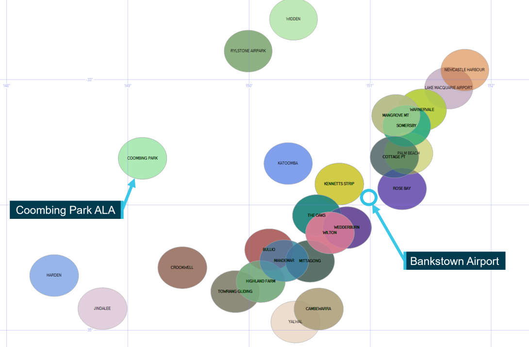
Image showing relative location of ALAs flown past by the instructor compared to Bankstown Airport and Coombing Park ALA
Source: ATSB
The analysis revealed that the instructor passed at least 59 ALAs at least once from a total of 138 flight data files between 2016 and the time of the accident. Forty-three of these ALAs were located in New South Wales, 10 in Queensland and 6 in Victoria. Approximately half of these ALAs (30) were not included in the ERSA, with the remaining 29 ALAs being listed. The flight data revealed that for most flights there was no evidence of the aircraft joining the circuit pattern at these ALAs, however, these locations were sometimes used as waypoints, characterised by a change in direction of the aircraft track. The most common locations passed were on the eastern side of the Great Dividing Range and between Newcastle to the north and Goulburn to the south.
Coombing Park was passed once by the instructor on 21 September 2018, with 2 heading changes occurring as the aircraft passed overhead (Figure 14). However, there was no evidence to suggest that any circuit or landing (including a precautionary search) was conducted at that time. No other evidence was identified for flights by the instructor to Coombing Park.
Figure 14: Flight by the instructor within 5.5 km of Coombing Park on 21 September 2018
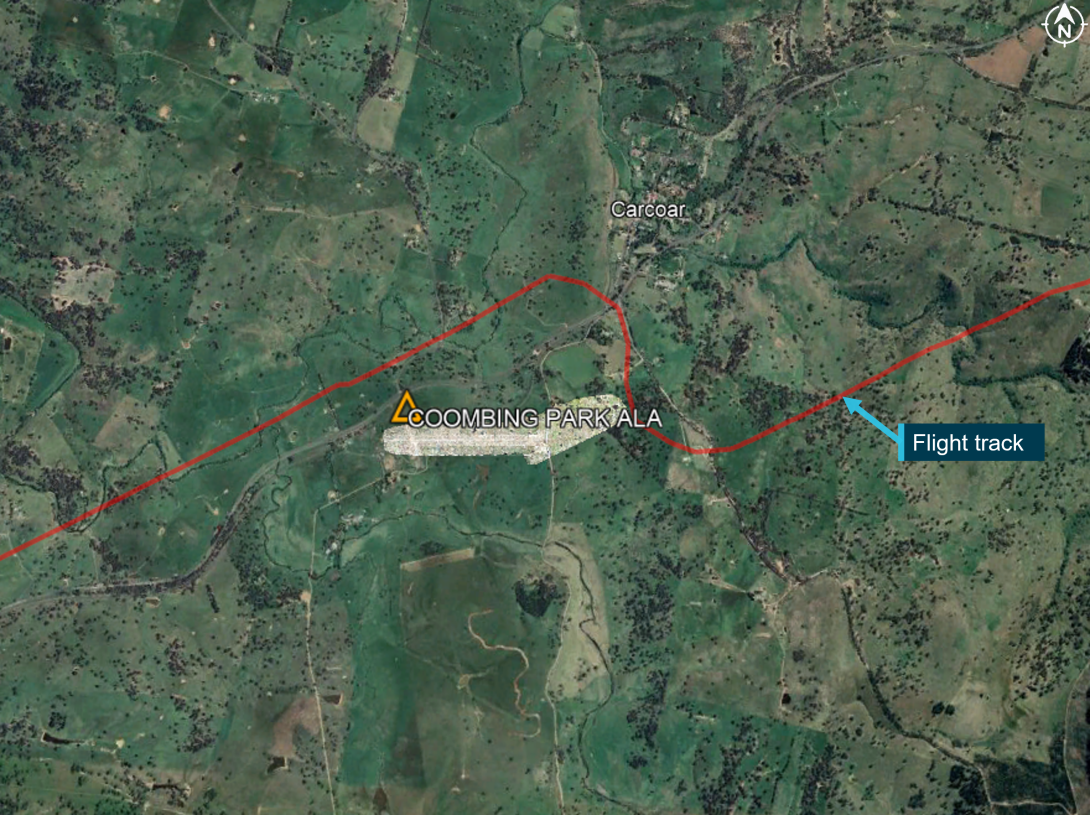
Image showing top down map of Coombing Park ALA and Carcoar township. Red line depicts the flight track.
Source: Google Earth, annotated by the ATSB
There were 2 occasions identified where precautionary searches likely occurred at ALAs (Mangrove Mountain ALA and The Oaks ALA), with a landing possibly occurring at The Oaks. The flight data also indicated that a precautionary search was likely conducted at Mangrove Mountain ALA, a non-ERSA ALA on 3 November 2018.
In this case, the flight track did not pass along, or directly approach the runway, indicating that a landing did not occur. One flight, on 14 January 2017 indicated that the Oaks ALA (which was included in the ERSA) was likely used for a precautionary search and landing. In summary, the instructor’s previous flights stored by OzRunways did not provide evidence of any previously conducted landings at non-ERSA ALAs.
Civil Aviation Advisory Publication 92-1(1) Guidelines for aeroplane landing areas
As detailed previously, the Soar operations manual only allowed operations to non-ERSA ALAs when they had been assessed to conform to the recommendations in Civil Aviation Advisory Publication (CAAP) 92-1(1) - Guidelines for aeroplane landing areas (the CAAP), and this had been approved by Soar’s head of operations. Such an evaluation of Coombing Park ALA had not been performed by Soar.
CAAP 92 overview
At the time of the accident, the introduction of the CAAP, released in July 1992, noted:
This publication sets out methods that may be used and which experience has shown should, in the majority of cases, ensure compliance with the Regulations. However, before using the information in this publication the user should always read the Civil Aviation Regulations listed…’
The CAAP then stated:
These guidelines set out factors that may be used to determine the suitability of a place for the landing and taking-off of aeroplanes. Experience has shown that, in most cases, application of these guidelines will enable a take-off or landing to be completed safely, provided that the pilot in command: (a) has sound piloting skills; and (b) displays sound airmanship.
CAAP 92 assessment of Coombing Park
The ATSB assessed Coombing Park ALA against the obstacle clearance recommendations of the CAAP. This recommended the ‘approach and take-off areas to be clear of objects above a 5% slope for day...operations’. This was an area extending 900 m beyond the end of the runway and is illustrated in Figure 15. The accident flight path was within this area prior to the final left turn (Figure 10).
Figure 15: Summary of eligibility requirements for ‘other’ physical characteristics of a CAAP 92-1(1) aeroplane landing areas
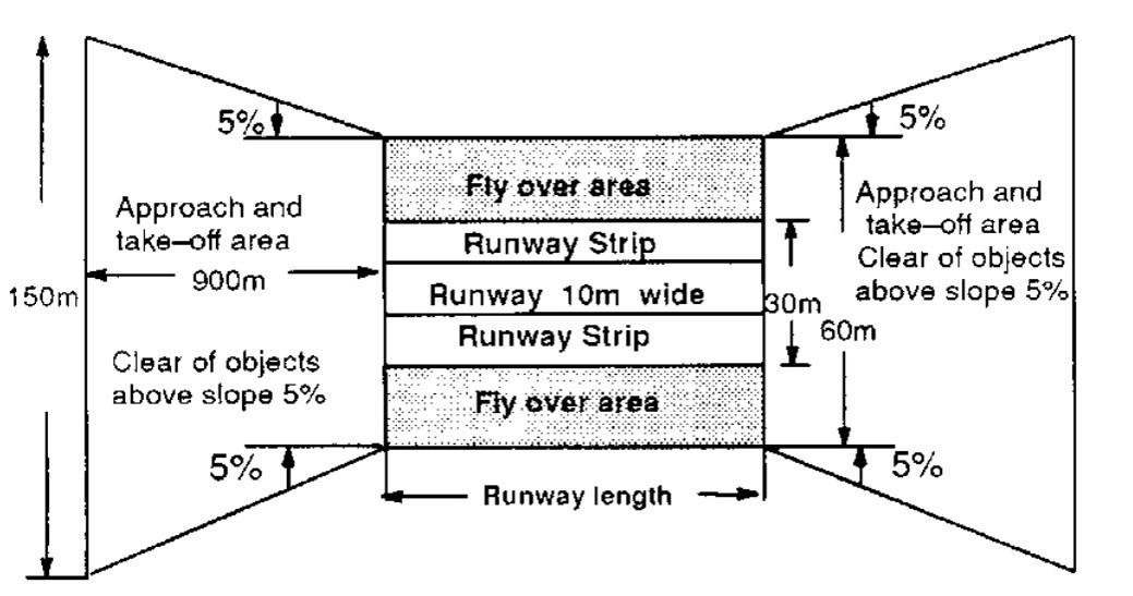
Source: Civil Aviation Safety Authority, CAAP 92-1(1) ‘Figure 2A – Single engined [sic] and Centre-Line Thrust Aeroplanes not exceeding 2000 kg MTOW (day operations)’
Table 1 shows Coombing Park ALA compared to the minimum recommended requirements of the CAAP for the approach and take-off area slope. The 2 left-most columns show the required CAAP value and relevant characteristic, with the 4 right-most columns relating to measurements conducted for Coombing Park ALA. Three sets of measurements were conducted for Coombing Park ALA based on the actual runway length, and characteristics if the runway length was shorter. The purpose of the theoretical measurements was to examine if the minimum recommended obstacle clearance requirements of the CAAP could be met at Coombing Park if runway 07 was shortened, increasing the distance between the runway 25 threshold and the rising terrain and obstacles to the East of the field.
Runway length requirements (CAAP 92(1)-1 Clause 5.1) and theoretical shortened runway calculations were based on 2 scenarios. The first scenario labelled ‘Theoretical shortened runway– AT01 Nil wind TODR [take‑of distance required]’ simulated a scenario where the runway was shortened to match the take-off distance required for VH-OIS on the day of the accident in nil wind. This represents a baseline scenario.
This calculation was based on VH-OIS performance charts for the estimated density altitude on the day of the accident, with an increase of 25% length for a short dry grass surface at Coombing Park. This data was considered ‘factored’ for the purpose of CAAP 92(1)-1 clause 5.1 that recommended an additional 15% be added to the length when using ‘unfactored’ data. The other scenario labelled ‘Theoretical shortened runway– worst case standing take-off’ is the result of a 5% slope applied from the location of the longest estimated standing take-off (836 m), as described in the section titled Evaluation of touch‑and‑go length and shown in Figure 7.
Table 1: Partial comparison of Coombing Park ALA to recommended minimum physical characteristics of landing areas according to CAAP 92-1(1) section 5 for Aquilla AT01 day operations
| CAAP 92 recommendations | Coombing Park Measurements | |||
| (Clause) Characteristic | Recommended value | Estimated 4 Nov 2020 state | Theoretical shortened runway – AT01 Nil wind TODR | Theoretical shortened runway – worst case standing take-off |
| Runway length | 1200m | 661m | 850m | |
| (5.5) Approach and take-off area slope | No obstacles above 5% out to 900 m beyond threshold | Take-off slope surface penetrated terrain | Take-off slope surface clear of terrain, possibly penetrated trees | Take-off slope surface clear of terrain, likely penetrated trees |
The assessment against CAAP 92-1(1) recommendations revealed that Coombing Park ALA likely did not meet obstacle clearance recommendations for VH-OIS at the time of the accident. Approach and take-off area slopes are illustrated in Figure 16 relative to the terrain profile (and upwind climb profile of OIS for reference), as also shown in Figure 7. These slopes are shown by the yellow, blue and orange lines, and have labels prefixed with ‘CAAP 92 surface...’ in Figure 16. Each of the 3 obstacle clearance slopes terminated 900 horizontal metres from the (simulated and actual) runway ends, as per the recommendations in CAAP 92-1(1). For reference, the horizontal axis shows the distance from the start of runway 07, corresponding to figures shown earlier. This shows that the CAAP 92-1(1) obstacle clearance surface originating from the end of runway 07 penetrated the rising terrain about 150 m from the runway end (orange line), as also noted in Table 1.
Figure 16: CAAP 92(1)-1 Runway approach and take-off obstacle clearance slope from various theoretical runway end positions projected onto the terrain profile of Coombing Park ALA compared to actual climb performance of VH-OIS
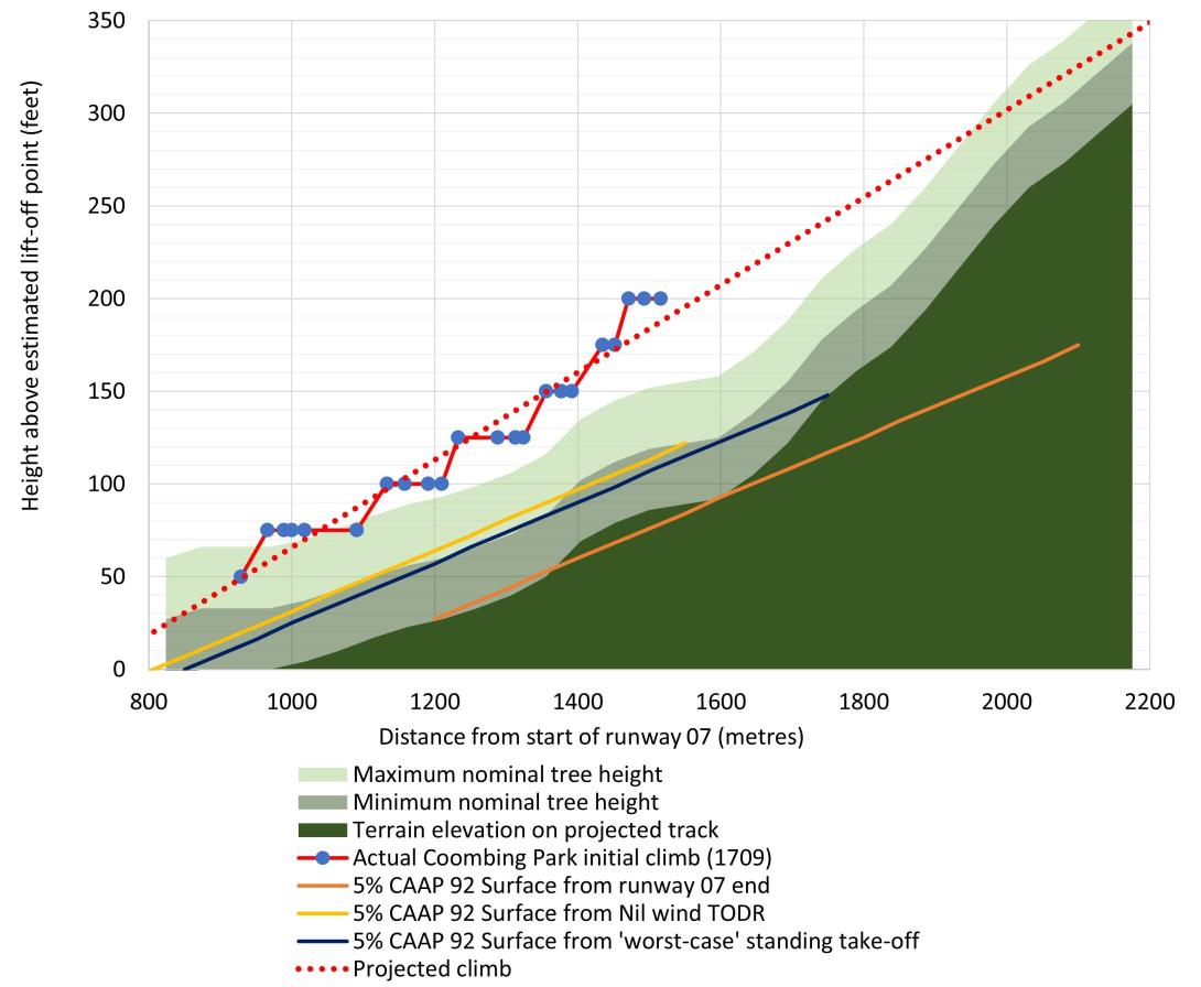
Figure showing plot of height vs distance travelled of OIS during the initial climb from Coombing Park ALA runway 07 compared to terrain and projections for the CAAP 92 obstacle clearance slope
Source: ATSB
The approach and take-off slope originating from the theoretical ‘nil wind’ shortened runway distance (shown in yellow) did not intersect with the terrain within the 900 m horizontal limit. However, this may have intersected with some of the trees in this area, and the projection of the shortened runway slope intersected the rising terrain approximately 250 m beyond this point.
The approach and take-off slope from the estimated worst-case standing take-off for VH-OIS is also shown in Figure 16 by the blue line. This also shows that the approach and take-off slope may have passed the CAAP 92 recommendation for a 5% obstacle clearance within 900 m, although this intersected with the terrain almost immediately after this point. However, it is likely that trees in this area would have penetrated this slope. Note that the CAAP 92 slopes from both theoretical shortened runways shown in Figure 16 correspond to theoretical take-offs shown in Figure 7 of the same colour.
Related occurrences
The ATSB’s national aviation occurrence database was reviewed to identify accidents and serious incidents involving collisions with terrain at ALAs that were reported to the ATSB in the 30 years between 1991 and 2020. These records were refined to occurrences where the characteristics of the runway and surrounding terrain may have influenced the outcome. In total 9 occurrences were identified meeting these criteria over this period.
Three of the occurrences identified related to ALAs listed in the ERSA and were therefore approved for use by Soar’s operations manual. One of the 3 ALAs were located at a similar or shorter distance than Coombing Park ALA was to Soar’s base of operation at Bankstown Airport (within range of Soar). A summary of these occurrences is below.
- ATSB investigation AO-2018-025 Runway excursion and collision with terrain – Van’s RV-6A, VH-OAJ, Somersby ALA, New South Wales on 18 March 2018. This investigation found that features surrounding the runway, including undulating terrain and a small watercourse immediately at the end and trees at the edge, increased the likelihood and severity of occupant injury in the case of a runway excursion. And further, that CAAP 92-1(1) did not have guidance for the inclusion of a safe runway overrun area.
- ATSB occurrence 200903966 Collision with terrain involving a Piper Aircraft Corp PA-31, Bungle ALA (Bellburn), Western Australia on 06 June 2009. During final approach to runway 10, the aircraft's right wing tip struck a tree branch, causing minor damage to the leading edge. This was a commercial charter flight with one pilot and 9 passengers onboard. A review of the approach area to runway 10 at Bungle ALA did not reveal any significant undulation in terrain, however there appeared to be slight height variation near the runway threshold. This ALA was in the ERSA and the occurrence is also notable because it relates to a charter operations to an ALA in the ERSA that was not assured as meeting CAAP 92-1(1) obstacle clearance recommendations.
- ATSB Occurrence 199700351 Collision with terrain involving an unknown ultralight aeroplane, Coominya ALA, Queensland on 9 February 1997. The pilot was attempting an uphill take-off. Soon after becoming airborne, the pilot reported becoming concerned about the closeness of the trees off the end of the runway. The pilot commenced a 180-degree turn, although the aircraft struck trees before the turn was completed. Subsequently, the aircraft struck the ground nose first and the pilot received serious injuries during the impact.
A further 2 occurrences were identified by the ATSB that were within range of Soar but were not listed in the ERSA. Therefore, these aerodromes were not approved for use for Soar operations without further risk assessments being conducted. These occurrences appear to be related to either obstacles and or terrain in the take-off and landing areas. These are of note because all aerodromes were eligible for entry in the ERSA (subject to a risk assessment), making them approved for use by the Soar operations manual.
- ATSB investigation AO-2018-013 Collision with terrain involving Cessna 206, VH-WZX, Apollo Bay ALA, Victoria on 31 January 2018. There was a pilot and 5 passengers on board. The ATSB found that a go-around commenced late during the landing and the pilot did not immediately follow the go-around procedure. These factors, combined with the heavy aircraft weight and rising terrain, reduced obstacle clearance and the aircraft struck the airfield boundary fence.
- ATSB Occurrence 201901041 Collision with trees involving Piper Aircraft Corp PA-38, VH‑CNT, Currandooly ALA, New South Wales on 23 February 2019. During the initial climb, the aircraft was unable to outclimb rising terrain and stuck trees. The aircraft subsequently collided with terrain resulting in substantial damage to the aircraft and minor injuries to the pilot. The occurrence is notable because the sequence of events and terrain appear similar to the accident scenario for VH-OIS. The aerodrome was within range of OIS from Soar’s base of operations at Bankstown Airport.
Safety analysis
Introduction
While conducting an assessment in preparation for a commercial pilot’s licence flight test, an Aquila AT01 registered VH-OIS (OIS), conducted a precautionary search at Coombing Park Aeroplane Landing Area (ALA), about 27km south of Orange Airport, New South Wales. Flight data indicated that after three precautionary search patterns were flown, a touch‑and‑go was conducted, with the aircraft climbing toward rising terrain after take-off. As the aircraft approached an area of steeper terrain, a climbing left turn was conducted toward a slightly lower and less wooded area. The aircraft continued to fly in a controlled manner, likely accelerating and descending slightly toward an open area of rising terrain beyond a small dam. After flying over the dam, the aircraft collided with an embankment, bordering the dam and the open area.
Site and wreckage examination, and aircraft performance assessments did not identify any defects, anomalies or sudden performance loss that might have contributed to the accident. Additionally, no evidence was found to suggest any medical or fatigue related issues that would have affected the pilots’ performance on the day of the flight. Therefore, this analysis will focus on the operational factors that led to an experienced flight instructor and a commercial student pilot to conduct a touch‑and‑go toward rising terrain that the aircraft was unable to outclimb.
Development of the accident
Pre-flight planning
Due to the nature of the flight, in preparation for the commercial pilot licence flight test, only the instructor is likely to have been aware of Coombing Park ALA being a waypoint for the flight prior to departure, although it is not known if a landing was originally planned by the instructor. Coombing Park ALA was not listed in the ERSA and therefore, use of the ALA for landing was not approved by the company operations manual without further assessment, which had not been performed. This requirement was likely known to the instructor as it had been in the operations manual for at least one year. For this accident, if this procedure was followed, the aircraft would not have landed.
It was reported by staff at Soar that a previous register existed which contained Coombing Park ALA as an approved aerodrome. However, this register could not be provided to the ATSB. Further, if a risk assessment was performed by Soar for Coombing Park ALA previously, it is unlikely that it would have been identified as suitable for conducting a landing. This is due to the rising terrain to the east not meeting the recommendations of CAAP 92-1(1). It is also considered likely that the flight instructor would have reached the same conclusion if this hazard was assessed prior to flight.
It was also reported that the flight instructor was likely familiar with the ALA. This is consistent with one previous flight identified by the ATSB, where Coombing Park ALA was likely used as a waypoint by the instructor. However, there were no flights identified where the instructor conducted a precautionary search or landing at Coombing Park ALA. Therefore, there was no evidence that suggests the instructor had an opportunity to effectively assess the rising terrain hazard for conducting a take-off, touch-and-go or landing at Coombing Park ALA in previous flights.
The flight instructor contacted the manager of Coombing Park ALA to seek permission to conduct a touch-and-go while OIS was in the circuit area after 2 complete precautionary search patterns. This phone call only lasted 24 seconds. This was the only telephone call that the manager of Coombing Park ALA received from the instructor that day and could not recall receiving a phone call from any instructor from Soar in the past. The manager of the ALA reported that they usually provided a more in depth briefing for people calling ahead of time. This likely represents a missed opportunity to gain a knowledge of present conditions, operating procedures and hazards to be aware of.
It should be noted that until the point where the decision was made to conduct a touch-and-go, the flight had proceeded as expected. This included conducting the precautionary search patterns. Although it could not be confirmed, it is likely that the instructor considered the risk of a touch-and‑go to be low. This was likely based on Coombing Park ALA having a sufficient runway length for a landing (not a touch-and-go). It was not established if the instructor had intended on flying to Coombing Park ALA before the flight. However, the timing of the phone call to seek permission to conduct a touch-and-go after completion of two precautionary search patterns, may indicate that the decision to conduct a touch-and-go by the instructor was a last-minute decision. This was possibly under a motivation to provide a realistic experience for the student.
Overall, it is likely that if the suitability of conducting a touch-and-go at Coombing Park ALA was assessed prior to flight, the instructor would have identified Coombing Park ALA as unsuitable for landing. Therefore, it is expected to be likely that there was limited planning conducted prior to the flight with respect to assessing the suitability of Coombing Park ALA for a landing, take-off or touch‑and‑go. It is also possible that the decision to conduct a touch-and-go was an impromptu deviation from the original plan. Further, the lack of planning, or deviation from the original plan, removed a defence, placing more pressure on assessments in flight (which were also ineffective). These factors reduced assurance that the aircraft could outclimb the rising terrain, which subsequently led to the accident occurring.
Conduct of precautionary search
The southerly and easterly legs of each precautionary search pattern flown at Coombing Park ALA likely provided the best opportunity for the pilots to identify the rising terrain hazard to the east.
The easterly inspection legs running parallel to the runway in the direction of landing were the inspection runs, For the duration of the third easterly leg, OIS was in a climb from 500 to 800 ft AGL, about 150 to 450 ft above the ridge and over 1 km to the right of the runway centreline. During this leg, the elevated nose position of OIS would have likely made assessing the rising terrain more difficult. Additionally, the changing perspective of the terrain may have been more apparent if the aircraft was in a straight and level configuration. In the two earlier patterns, the easterly legs were flown at more than 750 ft AGL, more than 400 ft above the ridgeline. Further, in all legs, OIS was more than 1 km to the right of the runway centreline, reducing the opportunity for the pilots to assess the overshoot area (and the runway surface).
At the start of the third pattern while tracking on the southerly leg (the third southern leg), OIS descended to a minimum height of about 450 ft AGL. Although this leg was only about 100 ft above the ridgeline on the extended centreline for runway 07 (the ridge), it was 3.3 km away from OIS.
Southerly legs were not considered inspection runs in the Soar ‘patter notes’ (these were the eastern legs), with these inspection runs noted to be flown at the lowest heights during the precautionary search patterns. Despite this, the third southern leg was flown at the lowest height of any legs at Coombing Park ALA during the precautionary search, prior to the final approach for the touch-and-go. This was at least 250 ft higher than recommended by the Soar ‘patter notes’ when conducting an actual precautionary search inspection run. This guidance was generally aligned with procedures for other organisations.
It is expected that the perspective offered by the ridge being slightly below the aircraft and more than 3 km away on the third eastern leg, reduced the likelihood that the pilots would identify this as unsuitable for take-off from runway 07. Further, the (easterly) inspection runs were flown at heights above the ground and offset positions from the runway centreline that likely reduced the pilots’ ability to detect the significance of the ridge at the end of runway 07 for take-off.
Therefore, it is likely that the heights and positions of OIS during the precautionary search patterns flown at Coombing Park ALA likely limited the opportunities for the pilots to detect the rising terrain hazard at the end of the runway, contributing to the decision to conduct a touch-and-go.
Take-off direction
It is likely that the ideal direction for landing and take-off were in opposite runway directions at Coombing Park ALA at the time of the accident. For landing, the light tailwind on runway 07 was countered by an uphill slope. Therefore, it is possible that either runway 07 or runway 25 would have allowed the shortest landing distance. However, there were fewer obstacles on approach to runway 07, likely making the approach less demanding on the pilots compared to runway 25.
The headwind component and downhill slope on runway 25 indicated that using that runway for a standing take-off would likely have allowed OIS to take-off in a shorter distance along the runway compared to runway 07. Further, due to no significant obstacles beyond the end of runway 25, it is very likely that OIS would have been able to safely climb away after lift-off. Finally, a standing take-off on runway 25 would have allowed OIS to start the take-off roll from the beginning of the runway, allowing the entire length to be used.
Therefore, a landing on runway 07, followed by a standing take-off on runway 25 would have likely prevented the accident.
The ATSB conducted further analysis (described in the next section) for a standing take-off compared to a touch-and-go on runway 07. This indicated that OIS may have been able to clear the terrain if a standing take-off was conducted on runway 07.
Touch-and-go
All touch-and-goes conducted by the student at Orange Airport likely used more runway than the standing take-off at Orange Airport (based on the distance from the runway threshold to the end of the take-off (where the aircraft climbed to 50 ft)). The touch-and-go conducted at Coombing Park ALA was likely typical of those conducted at Orange, with the approach reported by an eye‑witness as appearing normal. Based on flight data and calculations from the aircraft flight manual for OIS, the estimated standing take-off length at Coombing Park was estimated to be between 630 and 836 m, shorter than the actual touch‑and‑go length of 929 m. Therefore, it is very likely that a standing take-off would have led to OIS becoming airborne earlier along runway 07, reducing the likelihood of a collision with terrain.
There are more factors involved with the conduct of a touch-and-go compared to a standing take-off. This is supported by available literature and flight data for OIS that indicated a higher variability and longer length rolls from every touch-and-go compared to a standing take-off. This supports that there is likely less consistency with the length of a touch‑and‑go compared to a standing take-off.
ATSB analysis identified that the reduced runway length required by conducting a standing take-off at Coombing Park ALA was estimated to increase the height of OIS between a worst-case of 22 and a best-case of 70 ft at each point in the initial climb. This would have increased the margin between OIS and the terrain, in particular the trees. Adding the worst-case standing take-off height gain (22 ft) to the projections for the touch-and-go for different initial climb routes shows that all climb routes would have likely cleared the terrain by a greater height than the trees.
For a worst-case standing take-off, these estimations predicted these initial climb options pass the terrain by about 67 ft if tracking on the runway centreline up to 92 ft if a flight up the gully was conducted. The options to turn right, continuing the left turn, or climbing away from overhead the dam were all predicted to the terrain by a minimum of 88 ft. However, based on these estimations, and the maximum nominal height of trees being about 66 ft, it should be noted that any escape flight path would have still been at a very low height.
Therefore, the additional height offered by the worst-case standing take-off would have likely provided more options to the pilots, likely allowing the pilots to climb away from the terrain.
Forced landing
During the initial climb, the aircraft was likely performing normally. A projection of the flight path for OIS on the original track during the initial climb showed the aircraft likely would have collided with trees if flight was continued in that direction. It is likely that the pilots realised that the aircraft would be unable to outclimb the terrain and elected to turn left toward terrain that was less steep. Flight data analysis indicated that it was unlikely the pilots could have continued the left turn or conducted a right turn without colliding with trees. The aircraft rolled level flying toward the small dam, with flight data indicating that the aircraft was likely accelerating and descending just prior to crossing the surface of the dam. This indicates that the aircraft was likely in a controlled state at this point, about 1 second prior to impact. Based on this data, possibly after realising they would be unable to out climb the terrain, it is likely that the pilots were attempting to gain airspeed to affect a transition for an uphill forced landing. There was also likely minimal time for the pilots reconfigure the aircraft for a forced landing. During this attempted forced landing, the aircraft collided with the embankment of the dam.
Operator’s procedures
Soar's operations manual allowed training flights to be conducted to any aerodrome deemed suitable as part of a scenario-based training program. All aerodromes listed in the ERSA were considered as suitable for flight training operations. Therefore, Soar procedures did not require further assessment of ALAs listed in the ERSA. Further, for entry and ongoing listing in the ERSA, ALAs did not require any assessment of aerodrome suitability for aircraft operations.
In contrast, to be considered as suitable for flight training operations, ALAs not included in the ERSA were required to be assessed and found to meet all recommendations in CAAP 92-1(1). Therefore, Soar’s operations manual was inconsistent in the treatment of operational hazards between operations to ALAs listed in the ERSA and non-ERSA ALAs. This means that there were fewer controls in place to assure that obstacle clearance surfaces were suitable for use by Soar at ALAs listed in the ERSA.
Based on Soar operating in the aerial work category, the guidance in CAAP 92(1)-1 was suggesting that Soar would be expected to provide evidence to pilots on the suitability of landing areas. Although Coombing Park ALA was not in the ERSA, it was eligible to be without any further assurance that it was suitable for use by Soar. This is important because this ALA could have been approved for Company operations and would have resulted in the accident occurring at an ALA considered as suitable for company operations.
In summary, the CASA sample operations manual wording adopted directly by Soar Aviation provided approval for operation to ALAs in the ERSA without providing evidence and assurance that these were suitable for use by company aircraft.
CAAP 92 Recommendations
The Soar operations manual required that all ALAs not in the ERSA be assessed against the recommendations of CAAP 92-1(1) prior to use. Although this assessment was not performed for Coombing Park ALA, it could have been.
Section 5.5 of CAAP 92-1(1) included the recommendation that the terrain be clear of objects above a slope of 5% up to a distance of 900 m, however, there was no requirement for obstacle clearance beyond this distance. Coombing Park ALA had terrain that became steeper away from the runway. These circumstances may lead to situations where an aircraft is unable to safely climb away from the runway, despite the ALA meeting CAAP 92-1(1) obstacle clearance recommendations. There is also no assurance that other ALAs do not exist with these characteristics.
Coombing Park ALA did not meet the CAAP 92-1(1) recommendations for obstacle clearance beyond runway 07. However, if runway 07 was shortened, increasing the distance by displacing the runway 25 threshold, but still remaining at a suitable length for use by the accident aircraft, it is possible that the ALA would have met these recommendations. With the displaced runway 25 threshold, the ALA would likely have met these recommendations if several trees were removed from the take-off and approach area at the end of runway 07.
ATSB analysis showed that if the accident aircraft had conducted a standing take-off, it probably would have cleared the trees and terrain during the upwind climb by a very narrow margin. This situation would have been worse in an aircraft meeting minimum climb gradient requirements.
In summary, the CAAP 92-1(1) guidance did not assure that an aircraft would be able to safely outclimb rising terrain located more than 900 m from the end of a runway. This would have applied at Coombing Park ALA if the runway ended near the point of lift off.
Findings
|
ATSB investigation report findings focus on safety factors (that is, events and conditions that increase risk). Safety factors include ‘contributing factors’ and ‘other factors that increased risk’ (that is, factors that did not meet the definition of a contributing factor for this occurrence but were still considered important to include in the report for the purpose of increasing awareness and enhancing safety). In addition ‘other findings’ may be included to provide important information about topics other than safety factors. Safety issues are highlighted in bold to emphasise their importance. A safety issue is a safety factor that (a) can reasonably be regarded as having the potential to adversely affect the safety of future operations, and (b) is a characteristic of an organisation or a system, rather than a characteristic of a specific individual, or characteristic of an operating environment at a specific point in time. These findings should not be read as apportioning blame or liability to any particular organisation or individual. |
From the evidence available, the following findings are made with respect to the collision with terrain involving Aquila AT01, VH-OIS, Coombing Park ALA, 27 km south of Orange Airport, New South Wales, on 4 November 2020.
Contributing factors
- It is likely that pre-flight planning was not performed to ascertain the take-off area was clear of obstacles at Coombing Park ALA as required by the operations manual. Consequently, this reduced assurance that the pilots would identify and mitigate the risk of rising terrain that the aircraft was unable to outclimb at the end of runway 07.
- The pilots were conducting the precautionary search at heights and positions that would have likely made assessing the hazard of rising terrain from the air less effective. This likely contributed to the pilots’ decision to conduct a touch-and-go landing and take-off toward rising terrain that exceeded the climb performance of the aircraft and required a low-level turn to avoid rising terrain.
- The take-off was conducted on an uphill slope with a probable tailwind and toward rising terrain beyond the runway end. A standing take‑off conducted in the more favourable reciprocal direction would likely have cleared all obstacles and terrain.
- The conduct of the touch-and-go, rather than a standing take-off, reduced assurance that the aircraft would commence the climb from a position along the runway that could clear the terrain during the initial climb after take-off.
- The combination of loss in climb performance during the turn, trees and rising terrain in the new direction likely led to the pilots conducting an uphill forced landing. It is likely that the aircraft had insufficient performance for the uphill forced landing, leading to the aircraft colliding with the embankment of a small dam.
Other factors that increased risk
- The CASA sample operations manual used by the operator that allowed any aerodrome in the Enroute Supplement Australia to be used for flight training did not assure that these aerodromes were suitable for use. (Safety Issue)
- Recommendations in CASA guidance CAAP 92-1(1) requiring obstacle clearance out to 900 m may lead to circumstances where ALAs meet these requirements however, aircraft are required to manoeuvre below a safe height or be unable to outclimb rising terrain after take-off more than 900 m past the runway end. (Safety issue)
Safety issues and actions
|
Depending on the level of risk of a safety issue, the extent of corrective action taken by the relevant organisation(s), or the desirability of directing a broad safety message to the aviation industry, the ATSB may issue a formal safety recommendation or safety advisory notice as part of the final report. All of the directly involved parties are invited to provide submissions to this draft report. As part of that process, each organisation is asked to communicate what safety actions, if any, they have carried out or are planning to carry out in relation to each safety issue relevant to their organisation. Descriptions of each safety issue, and any associated safety recommendations, are detailed below. Click the link to read the full safety issue description, including the issue status and any safety action/s taken. Safety issues and actions are updated on this website when safety issue owners provide further information concerning the implementation of safety action. |
Sample operations manual
Safety issue number: AO-2020-059-SI-01
Safety issue description: The CASA sample operations manual used by the operator that allowed any aerodrome in the Enroute Supplement Australia to be used for flight training did not assure that these aerodromes were suitable for use.
CAAP 92 Guidance
Safety issue number: AO-2020-059-SI-02
Safety issue description: Recommendations in CASA guidance CAAP 92-1(1) requiring obstacle clearance out to 900 m may lead to circumstances where ALAs meet these requirements however, aircraft are required to manoeuvre below a safe height or be unable to outclimb rising terrain after take-off more than 900 m past the runway end.
Safety action not associated with an identified safety issue
| Whether or not the ATSB identifies safety issues in the course of an investigation, relevant organisations may proactively initiate safety action in order to reduce their safety risk. The ATSB has been advised of the following proactive safety action in response to this occurrence. |
Additional safety action addressing safety hazards at Coombing Park ALA
The property manager of Coombing Park ALA advised that the airstrip has been lengthened, extending the threshold of runway 07 by 300 metres to the west. Additionally, the threshold of runway 25 was displaced by 150 metres to the west, increasing the distance between this threshold and the rising terrain to the east of the field. Five large trees were also removed on the rising terrain to allow an escape route away from the rising terrain.
Glossary
ADS-B Automatic Dependent Surveillance Broadcast
AIP Aviation information publication
ALERFA Alert phase
ATC Air traffic control
CASA Civil Aviation Safety Authority
CASR Civil Aviation Safety Regulations
CCTV Closed-circuit television
ERSA En route supplement Australia
IAS Indicated airspeed
ICAO International Civil Aviation Organization
INCERFA Uncertainty phase
Runway end End of runway in use.
Threshold Beginning of usable portion of runway, i.e. downwind end.
Touch-and-go Practice landing in which the aeroplane is permitted to touch runway briefly; in many cases flaps are moved to take-off setting while weight is on wheels.
Sources and submissions
Sources of information
The sources of information during the investigation included:
- accident witnesses
- Airservices Australia
- the Bureau of Meteorology
- the Civil Aviation Safety Authority
- the manager of Coombing Park ALA
- Soar Aviation Aircraft Holding Pty Ltd
- recorded data transmitted from the aircraft
- recorded data from the instructor’s OzRunway’s account
- photographs and videos taken of the aircraft on the day of the accident
References
Burnside, J. (2004). Airmanship: Touch and Goes? Aviation Safety Magazine, 20 September 2004. https://www.aviationsafetymagazine.com/
Geeting, D. & Woerner, S. (1988). Mountain flying (First edition), TAB Books Inc., Blue Ridge Summit, PA.
Vendeth, S (2003). A Pilot’s Guide to Safe Flying, A Manual for General Aviation Pilots (First Edition), Mt Eliza, Victoria, Australia
Wright, C. (2006). CFI to CFI rite of passage: The touchy subject of touch and goes. Flight Training Magazine, May 2006. https://www.aopa.org/
Submissions
Under section 26 of the Transport Safety Investigation Act 2003, the ATSB may provide a draft report, on a confidential basis, to any person whom the ATSB considers appropriate. That section allows a person receiving a draft report to make submissions to the ATSB about the draft report.
A draft of this report was provided to the following directly involved parties:
- the Bureau of Meteorology
- the Civil Aviation Safety Authority
- the manager of Coombing Park ALA
- Soar Aviation Aircraft Holding Pty Ltd.
Submissions were received from:
- the Bureau of Meteorology
- the Civil Aviation Safety Authority
- the manager of Coombing Park ALA
- Soar Aviation Aircraft Holding Pty Ltd.
The submissions were reviewed and, where considered appropriate, the text of the report was amended accordingly.
Appendices
Appendix – The influence of the touch‑and‑go landing on the accident involving VH-OIS, 4 November 2020
This appendix documents a short study conducted by the ATSB to investigate the potential contribution that conducting a touch-and-go may have had on the accident involving OIS on 4 November 2020 at Coombing Park ALA. The key objective was to show the differences that conducting a touch-and-go in comparison to a standing take-off may have had on the ability of OIS to outclimb the rising terrain in the upwind area of runway 07.
Methodology
Aireon flight data was used to estimate the distance between the runway threshold and the aircraft reaching a height of 50 ft. The runway threshold (at the beginning of the runway) was used as a relative reference marking the start of the take-off run or touch‑and‑go. This was to allow comparison between standing take-off runs and touch‑and‑goes. As such, this indicates the overall average performance of the aircraft and pilot flying combination. As this was a pre-CPL flight test assessment, the pilot flying is expected to be the student pilot in every case.
The flight data point indicating the climb to 50 ft (and hence take-off) was identified by firstly reading backward in time from an established initial climb to the local minima in the data. The 50 ft point was then found by reading the first data point 50 ft above the local minima after the time of the local minima. Although there were undulations along the runways at Orange Airport and Coombing Park ALA, this was not expected to have affected the results in the locations where the initial climbs started. Further, this is expected to be within the tolerances of the flight data rounded to the nearest 25 ft. Distances were estimated as great circles using the haversine formula[19] between the latitude and longitude of the runway threshold and the flight data point as OIS passed through 50 ft. The results of this analysis are shown in Figure 17.
Results
Estimation of take-off distance
The horizontal axis of Figure 17 shows the distance between the runway threshold, at the beginning of the take-off run, and climb to 50 ft above ground level. Values associated with Orange Airport are prefixed with ‘YORG’ and are colour coded as orange for runway 29, and yellow for runway 11. The touch‑and‑go at Coombing Park is indicated in purple and prefixed ‘YCPK’. Bars indicating touch‑and‑goes include ‘T/G’ in the label, with the standing take off at Orange Airport labelled ‘YORG T/O RWY 11 0537UTC’.
Figure 17 also shows calculated take-off distance required for each runway used at Orange Airport from the aircraft flight manual for OIS, with the label of these calculated values prefixed by ‘YORG AFM TODR’. These are based on the reported winds, density altitude and aircraft weight at Orange Airport at 1600 and 1630. Labels are all suffixed with the local time at the start of each run or the time of weather observation. Further, the open blue bars prefixed with ‘YCPK T/G est. at YORG’ show an estimated range of the Coombing Park touch‑and‑go distance if conducted at Orange Airport. The bar labelled ‘grass’ includes a correction for the dry grass runway, as required by the AFM for OIS, with the bar labelled ‘no grass’ indicating results without a surface correction. This analysis is described further below.
Figure 17: Distance from runway threshold to take-off for VH-OIS at Orange Airport and Coombing Park ALA, 4 Nov 2020
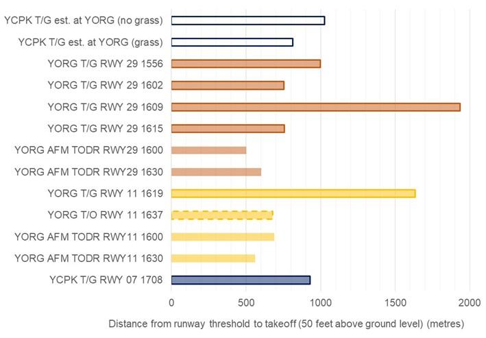
Source: ATSB
Comparison of Coombing Park ALA take-off position with previous touch‑and‑go runs
The measured distance between the runway threshold and take-off (the touch‑and‑go distance) at Coombing Park ALA was compared to the same distances for touch-and-goes conducted at Orange Airport. The length of the Coombing Park ALA touch-and-go was the third shortest of the flight. The two shortest touch-and-goes conducted at Orange Airport (1602 and 1615) had a length of just over 750 m. With the fourth shortest touch‑and‑go being the first approach conducted at Orange Airport (1556) at about 1,000 m.
Corrections for aircraft mass, density altitude and surface type were applied to the measured touch-and-go distance at Coombing Park to compare the length of the touch‑and‑go conducted at Coombing Park with those conducted at Orange Airport, as shown by the open blue bars in Figure 17. No correction was performed for wind to show potential variation from this as a factor. These corrections were performed as follows. The take-off distance required by the AFM (the AFM TODR) were calculated for Orange Airport and Coombing Park ALA based on the estimated aircraft take-off mass, pressure altitude and temperature at each location. The ratio between the AFM TODR between Orange Airport and Coombing Park ALA was calculated, and this was multiplied with the actual touch‑and‑go distance at Coombing Park, measured from OIS flight data, and is summarised by the following equation.

Where, LYCPK at YORG represents the estimated length of the Coombing Park ALA touch‑and‑go if it was conducted at Orange Airport. TODRYORG and TODRYCPK represent the take-off distances required for Orange Airport for reported conditions at 1600, and Coombing Park at 1700 respectively. Finally, LCPK represents the actual touch‑and‑go distance at Coombing Park measured from OIS flight data. The results of this calculation are shown by the ‘YCPK T/G est. at YORG (no grass)’ bar in Figure 17. In addition to this calculation, a correction for the grass runway was applied by multiplying TODRYCPK by 1.25, as recommended for a dry grass runway in the AFM for OIS and shown by the ‘YCPK T/G est. at YORG (grass)’ bar in Figure 17.
The estimated equivalent length of the touch‑and‑go conducted at Coombing Park ALA to Orange Airport accounting for grass was 812 m, about 8% longer than the shortest touch‑and‑go at Orange Airport. Without accounting for grass, the Coombing Park ALA touch‑and‑go projection was about 260 m longer than the shortest touch‑and‑go at Orange Airport, and marginally longer (about 15 metres) than the first touch‑and‑go conducted at 1556. The surface at Coombing Park appeared in good condition at the time of the accident, with the surface being firm, the grass relatively short, and the conditions dry. It is expected that the grass correction factor is an upper limit for the calculation of the potential length, with the lower limit being the calculation without accounting for grass.
The touch-and-go approaches at 1609 and 1619 had lift-off points considerably further along the runway than the other runs and were consistent with flight assessment exercises being conducted. The altitude profile of the 1609 touch‑and‑go was consistent with a go-around followed by a second, later touch-down, possibly simulating an early upwind engine failure. The touch‑and‑go at 1619 was likely following a practiced glide approach onto the reciprocal runway 11. These exercises were expected elements to assess the suitability to conduct a CPL flight test.
As no wind correction was applied to the estimated projection of the Coombing Park ALA touch‑and‑go length to Orange Airport, this calculation reflects the wind speed and direction as applicable at Coombing Park ALA during the touch‑and‑go at 1708. The Bureau of Meteorology identified that there was unlikely to be a headwind component during the touch‑and‑go at Coombing Park ALA. Further, based on the reported wind conditions at 1600, it is likely that a headwind component of approximately 6 kt was present at about the time of the shortest touch‑and‑go at 1602 at Orange Airport. In addition, the touch‑and‑go at 1556 likely used more runway than the Coombing Park ALA touch‑and‑go if this was conducted at Orange Airport, despite the likelihood of a 6 kt headwind component at Orange Airport during this touch‑and‑go. Therefore, a weaker headwind component is expected to have contributed to a longer landing at Coombing Park ALA than the shortest touch‑and‑goes conducted. However, based on the uncertainty in the meteorological data, and the ground speed of OIS from flight data being close to the published short field approach speed, it was not possible to determine the precise impact of wind on the touch‑and‑go distance at Coombing Park ALA.
In summary, compared to the length of the touch‑and‑goes conducted at Orange Airport, the Coombing Park ALA touch‑and‑go was the third shortest of the flight. The touch‑and‑go at Coombing Park ALA was the third shortest touch-and-go of the flight with and without density altitude corrections. Although the precise impact of the grass surface could not be determined, it is expected that this would have had the effect of reducing the projected length toward the two shortest touch‑and‑goes. Additionally, the touch‑and‑go conducted at Orange Airport at 1556 likely used more runway than an equivalent length touch‑and‑go conducted at Coombing Park at 1708, despite the 1556 touch‑and‑go likely having a larger headwind component. Based on analysis of the flight data for OIS, it appears likely that the touch down length was within the normal variability of touch-and-goes conducted by the student. Therefore, the above suggests that the length of the touch-and-go conducted by the student at Coombing Park ALA was typical of touch-and-goes conducted at Orange Airport earlier in the flight.
Estimation of standing take-off distances
The ATSB conducted an analysis examining the potential effect from performing a standing take‑off instead of the touch‑and‑go at Coombing Park ALA under the same conditions. The purpose was to estimate the maximum distance where OIS would have lifted-off along the runway at Coombing Park ALA if a standing take-off was conducted using two independent methods. One method (the ratio method) to estimate this distance was similar to the projection of the Coombing Park ALA touch-and-go to Orange Airport described above. For this method, the ratio between the standing take-off at 1637 and the measured touch‑and‑go distance was calculated, and this result was multiplied by the length of the Coombing Park ALA touch-and-go distance (929 metres). The other method was estimated standing take-off distance based on the AFM. Results from both methods are shown in Table 2.
Table 2: Standing take-off distance estimations for OIS at Coombing Park ALA runway 07
| Description of standing take-off estimation | Method | Take-off distance (m) |
| Estimation based on YORG touch and go at 1556 | Ratio | 836 |
| Estimation based on YORG touch and go at 1602 | Ratio | 630 |
| Take-off distance required – Nil wind factored by 25% for grass | AFM | 675 |
| Take-off distance required – 5 kt tailwind factored by 25% for grass | AFM | 825 |
The ratio of the shortest touch‑and‑go at 1602 at Orange Airport was calculated as 0.90, equating to the longest estimated standing take-off length of 836 m. The same was performed for the 1556 touch‑and‑go, with a ratio of 0.68, and representing an upper limit of the normal touch‑and‑goes conducted. This equated to the shortest estimated standing take-off at 630 m. Standing take-off estimates based on the take-off distance required from the AFM for OIS were between the ratio‑based estimates. These were both factored by 25% to account for the short-dry grass runway for no wind, and a 5 kt tailwind.
In summary, the standing take-off length at Coombing Park ALA was estimated to be between 630 and 836 m, notably shorter than the actual Coombing Park ALA touch‑and‑go length of 929 m.
Initial climb projections
The ATSB evaluated the potential influence of a standing take-off on the height of OIS during the initial climb. This analysis used the estimated standing take-off distances described in the section above and is illustrated in Figure 18. The vertical axis shows the height above the estimated point of lift off and the horizontal axis shows the distance from the start of runway 07 at Coombing Park ALA, and also corresponds to the markers shown in Figure 6. Terrain elevation is shown by the solid dark green area, with typical tree heights indicated by the translucent dark green (minimum 10m) and light green (maximum 20m) areas.
Figure 18: Height of initial climb profile for OIS at Coombing Park ALA, including estimations for climb profiles following standing take-off and estimated terrain profile
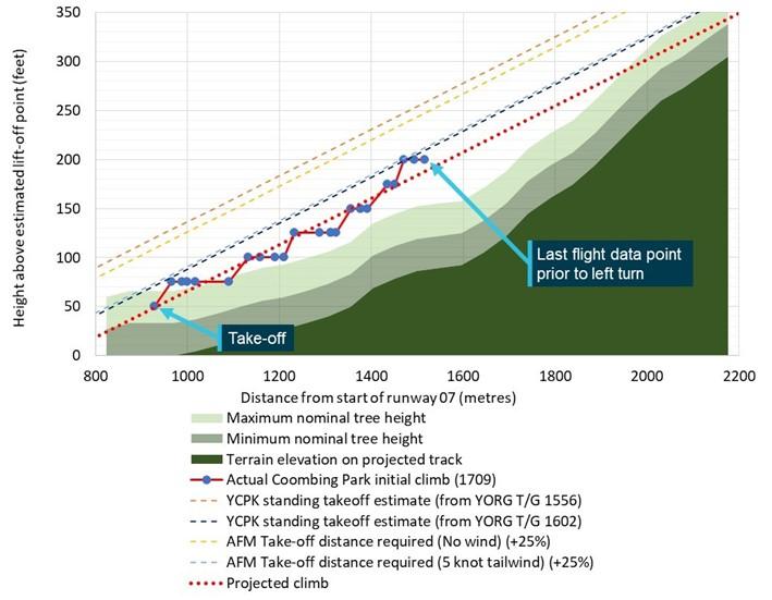
Figure showing plot of height vs distance travelled of OIS during the initial climb from Coombing Park ALA runway 07 compared to terrain and estimates for climb if a standing take-off was conducted.
Source: ATSB
The actual initial climb profile of OIS conducted at Coombing Park ALA at 1709 is shown in Figure 18 by the series with red lines and blue circles. The last data point of this series indicates the relative height of OIS immediately prior to the left turn. The red dotted series is the line of best fit for the 1709 initial climb and shows an estimated projection of the climb if the climb rate was maintained and OIS tracked in a straight line instead of turning left. The top right corner of Figure 18 shows the projected climb above the minimum nominal tree height but intercepting below the maximum nominal height.
Theoretical climb profiles representing each of the estimated standing take-off lengths shown in Table 2 are shown by the dashed light blue, dark blue, yellow, and orange lines. These were formed by translating the actual climb profile horizontally (indicated by the red-dotted line) to commence from each calculated standing take-off distance along runway 07.
The orange dashed line in Figure 18, labelled ‘YCPK standing take-off estimate (from YORG T/G 1556)’, shows the best-case estimate for a climb profile following a standing take-off at Coombing Park ALA, based on the estimated standing take-off length of 630 m. This estimate translated to be an estimated 70 ft higher than the climb following the actual touch-and-go at Coombing 1709 initial climb at each point in the climb. This was based on the mean difference between the intercepts from the equations of these lines shown in Figure 18. Similarly, the height of the worst‑case estimated standing take-off (836 m) was estimated to be 22 ft higher than the climb following the actual touch-and-go at Coombing Park ALA (shown by the dark blue dashed line in Figure 18). This represents the lower limit of the height difference. The climb profiles for the AFM-based standing take-off estimates listed in Table 2 are shown by the yellow and light blue dashed lines in Figure 18, between the other projections.
In summary, the vertical height difference between a standing take-off climb profile and the touch‑and-go climb profile was estimated by the ATSB. This was based on calculating the vertical difference between the actual climb profile following the touch-and-go at Coombing Park ALA, and theoretical climbs originating from the estimated location of standing take-offs. The analysis found that if a standing take-off was conducted at Coombing Park ALA, the height at each point during the initial climb would have likely been between 22 and 70 ft higher than the actual touch-and-go conducted by the student. The top right corner of Figure 18 shows all climbs following hypothetical standing take-offs as passing close to, but above the maximum nominal tree height at the local terrain peak.
Conclusion
Based on analysis of the flight data for OIS, the ATSB found that the length of the touch-and-go conducted by the student at Coombing Park ALA was typical of touch-and-goes conducted at Orange Airport earlier in the flight. The length of all touch-and-goes during the flight were notably longer than the standing take-off conducted at Orange Airport when corrected for density altitude (when the length was measured from the runway threshold to the point of take-off). These touch‑and-goes were also all longer than calculations using the aircraft flight manual for the accident aircraft (VH-OIS). When corrected for density altitude, a standing take-off length at Coombing Park ALA was estimated by the ATSB to be between 630 and 836 m for the atmospheric and weather conditions at the time of the accident, notably shorter than the actual Coombing Park ALA touch‑and‑go length of 929 m. This equated to OIS being between 22‑70 ft higher at each point during the initial climb if a standing take-off was conducted instead of a touch-and-go. In contrast to the initial climb after the actual touch-and-go projecting below the maximum tree height, climb projections from standing take-off estimates indicated that OIS as passing close to, but slightly above the maximum nominal tree height.
Purpose of safety investigationsThe objective of a safety investigation is to enhance transport safety. This is done through:
It is not a function of the ATSB to apportion blame or provide a means for determining liability. At the same time, an investigation report must include factual material of sufficient weight to support the analysis and findings. At all times the ATSB endeavours to balance the use of material that could imply adverse comment with the need to properly explain what happened, and why, in a fair and unbiased manner. The ATSB does not investigate for the purpose of taking administrative, regulatory or criminal action. TerminologyAn explanation of terminology used in ATSB investigation reports is available here. This includes terms such as occurrence, contributing factor, other factor that increased risk, and safety issue. Publishing informationReleased in accordance with section 25 of the Transport Safety Investigation Act 2003 Published by: Australian Transport Safety Bureau © Commonwealth of Australia 2023
Ownership of intellectual property rights in this publication Unless otherwise noted, copyright (and any other intellectual property rights, if any) in this report publication is owned by the Commonwealth of Australia. Creative Commons licence With the exception of the Coat of Arms, ATSB logo, and photos and graphics in which a third party holds copyright, this publication is licensed under a Creative Commons Attribution 3.0 Australia licence. Creative Commons Attribution 3.0 Australia Licence is a standard form licence agreement that allows you to copy, distribute, transmit and adapt this publication provided that you attribute the work. The ATSB’s preference is that you attribute this publication (and any material sourced from it) using the following wording: Source: Australian Transport Safety Bureau Copyright in material obtained from other agencies, private individuals or organisations, belongs to those agencies, individuals or organisations. Where you wish to use their material, you will need to contact them directly. |
[1] The primary source of flight data for this investigation was from ADS-B data transmitted by OIS, retrieved from space‑based ADS-B receivers operated by Aireon located on the Iridium satellite constellation.
[2] A high power run-up check is carried out in a piston-engine aircraft to check the aircraft’s ignition and other systems before commencing an initial take off.
[3] The term ‘pilots’ is used throughout this report to refer to one or both pilots flying the aircraft. There was no way to determine which pilot was flying the aircraft at any time during the flight.
[4] A climbing departure away from the airport in the same direction as the runway used for take-off.
[5] Closed pattern, usually circular or racetrack, followed repeatedly by aircraft.
[6] Uncertainty phase (INCERFA): an emergency phase declared by the air traffic services when uncertainty exists as to the safety of an aircraft and its occupants.
[7] A GAF provides a pictorial representation of forecast weather conditions and is designed primarily to meet the needs of pilots flying in the airspace between the surface and 10,000 ft (AMSL).
[8] A METAR is a routine report of meteorological conditions at an aerodrome.
[9] QNH: the altimeter barometric pressure subscale setting used to indicate the height above mean sea level.
[10] Ceiling and visibility okay (CAVOK): visibility, cloud and present weather are better than prescribed conditions. For an aerodrome weather report, those conditions are visibility 10 km or more, no significant cloud below 5,000 ft, no cumulonimbus cloud and no other significant weather.
[11] The ATSB uses IPCC definitions to communicate uncertainty regarding technical information. The 67% threshold is used by the ATSB to describe where the data likely lies, and 90% to describe where the data very likely lies. This is documented in ATSB report AR-2007-053.
[12] Australian Transport Safety Bureau (2008). AR-2007-053 Analysis, Causality and Proof in Safety Investigations, Canberra, Australia. This can be found on the ATSB’s website www.atsb.gov.au.
[13] Uncertainty data were generated from 67th (boxes) and 90th (whiskers) percentile confidence intervals of Student’s t-distribution derived from the standard error between the flight data and the mean climb rate.
[14] CASA Advisory Circular AC 91-02 v1.1 dated November 2021
[15] Aeroplane Flight Instructor Manual, Civil Aviation Safety Authority, Issue 2: December 2006.
[16] Vendeth, S (2003). A Pilot’s Guide to Safe Flying, A Manual for General Aviation Pilots (First Edition), Mt Eliza, Victoria, Australia
[17] https://www.aviation.govt.nz/licensing-and-certification/pilots/flight-training/flight-instructor-guide/precautionary-landing/
[18] Geeting, D. & Woerner, S. (1988). Mountain flying (First edition), TAB Books Inc., Blue Ridge Summit, PA.
[19] The haversine formula determines the great-circle distance (the shortest distance) between two points on a sphere given the longitude and latitude of each point. For the purpose of these calculations over the length of a runway, this method is suitable to estimate distance.