Turbulence/windshear/microburst

Boeing 767-238, VH-EAL

Safety Action

As a result of this occurrence, the operator has advised the ATSB that:

  • amended procedures for the dissemination of weather information to crews have been trialled since the occurrence, and documented procedures are being amended
  • an audio-visual presentation on the occurrence has been produced and provided to Airservices Australia
  • the audio-visual package was presented at an Airservices Australia/Airline Industry Forum
  • an awareness article was produced for dissemination to crews
  • a program to add a predictive windshear capability to the operators fleet is continuing.

1 Times indicated have been referenced from a number of sources, which used different time bases. Times obtained from the aircraft flight data recorder are EST+3 seconds and those obtained from Brisbane air traffic control are EST+7 seconds.
2 The average direction is based on mid-level wind direction.
3 The BoM reported that thunderstorms that move to the left or right of the average direction of the storm line, typically display severe characteristics.
4 Distance Measuring Equipment.
5 Windshear warning and predictive windshear warning functions were not required to be incorporated in the aircraft weather radar system.
6 BoM staff a meteorologist position in the operator's flight dispatch organisation.
7 Times are EST+3 seconds.

Significant Factors

  1. An intense thunderstorm developed in a short timeframe ahead of the main line of thunderstorms, producing heavy rain, hail and windshear, which the aircraft encountered shortly after take-off.
  2. Air traffic control and Bureau of Meteorology staff did not mutually exchange information regarding the thunderstorm as it developed and approached Coolangatta aerodrome.
  3. Coolangatta Air Traffic Services staff did not ensure that the crew were aware of the changed weather conditions and the new Automatic Terminal Information Service broadcast advising that thunderstorms were in the area.
  4. The crew did not have a complete and timely picture of a hazardous and rapidly deteriorating meteorological situation from which to make an accurate assessment of that situation.


Analysis

2.1 Introduction

The occurrence involving EAL involved a number of issues including the limitations of airborne weather radar, the mutual exchange of information between BoM and air traffic control, and provision of information to the B767 crew. Further, the occurrence involving EAL displayed a number of similarities with a Boeing 737 microburst encounter at Brisbane Airport on 18 January 2001.

2.2 The aircraft

2.2.1 Aircraft weather radar

The aircraft weather radar did not have the capability to provide predictive forward-looking windshear detection and avoidance information to the crew, nor was there a requirement for it to do so. That capability would have provided an early alert to the crew about the hazardous conditions that existed ahead of the aircraft and may have assisted them to avoid or minimise those hazards.

The presence of red or magenta on the aircraft weather radar display is a measure of rainfall intensity. The crew reported areas of red on the display, with no hooks, fingers, contours, scalloped edges or U-shaped returns that could have indicated the presence of hail or other adverse weather conditions. In addition, they reported that they assessed the areas of red on the weather radar display as heavy rain only. The crew could see heavy rain approaching the aerodrome, but were not aware of any associated adverse weather conditions, such as thunderstorm activity and hail. In the absence of any indications of adverse weather from either the aircraft weather radar or ATS, they would have been unaware of the presence of adverse weather conditions in the take-off flight path.

2.2.2 Aircraft flight path

The crew reported that they increased thrust in accordance with the operator's published windshear escape manoeuvre. However, recorded FDR data indicated that, throughout the windshear encounter, both EPR and thrust lever angle (TLA) remained in the take-off position until climb thrust was set when clear of the encounter. The investigation was unable to resolve the discrepancy.

2.2.3 Other aircraft movements

A number of other aircraft movements into and out of Coolangatta Airport occurred in the short time before EAL took off. None of those aircraft reported encountering adverse weather, including the Boeing 737 that took off from runway 32 about 15 minutes before EAL was issued clearance to take-off from the same runway. The absence of any reports of adverse weather encounters likely contributed to the crew of EAL assessing that the weather conditions that they could see visually, and which were displayed on the aircraft weather radar, consisted of heavy rain only.

2.3 Organisational issues

2.3.1 Bureau of Meteorology

The BoM reported that the thunderstorm encountered by EAL developed in a short timeframe ahead of the main line of thunderstorms. Forecasters became aware of the severity of the thunderstorm 9 minutes before EAL was cleared to take-off. Despite observing the storm cell move towards and pass over Coolangatta aerodrome, forecasters did not contact Coolangatta ATS to advise of the approaching hazardous weather.

2.3.2 Air Traffic Services

ATIS Echo was current until 1337:41. ATIS Foxtrot was issued at 1338:22. The crew requested taxi clearance, notifying receipt of ATIS Echo, 45 seconds after ATIS Foxtrot was issued. Accordingly, the crew had not been advised that thunderstorms were present within 5 NM of Coolangatta Airport.

The SMC controller did not inform the crew that the ATIS had changed and did not advise the crew of the change in weather conditions. Accordingly, an opportunity was missed to provide the crew with updated information of the prevailing meteorological conditions at the time that the aircraft was intending to take-off.

Coolangatta ATS controllers could see that the thunderstorm was approaching and that weather conditions were deteriorating, however, they did not contact BoM staff to ascertain the severity of the approaching weather. Consequently, neither BoM nor Coolangatta controllers had a complete picture of the deteriorating meteorological situation. In turn, the crew of EAL was not provided with a complete picture of the meteorological situation in the vicinity of Coolangatta Airport and their intended departure flight path.

Coolangatta ATS reported that they had access to the BoM PC-based METRAD/RAPIC display. Controllers were aware that information depicted on those displays could be up to 10 minutes behind actual time. Due to the rapid development of the thunderstorm cell encountered by EAL, the investigation was unable to confirm if the METRAD/RAPIC display would have been able to provide Coolangatta controllers with sufficient information to advise the crew of EAL of approaching hazardous weather.

2.4 Previous occurrence

The occurrence involving EAL displayed a number of similarities to a Boeing 737 microburst encounter that occurred at Brisbane Airport on 18 January 2001. The circumstances of the occurrence involving EAL indicate that the ATSB recommendations published in ATSB investigation report BO/200100213 remain valid.

Summary

1.1 History of the flight

1.1.1 Overview

On 26 October 2003, at about 1346 Eastern Standard Time, a Boeing 767-238 aircraft, registered VH-EAL, with two pilots, seven cabin crew and 207 passengers, took off from Coolangatta Airport, Queensland, on a scheduled regular public transport service to Sydney, NSW. The aircraft had arrived at Coolangatta earlier that day, having flown the first sector from Sydney to Coolangatta. Shortly after takeoff, passing through an altitude of about 800 ft, the aircraft encountered heavy rain, hail and windshear. The crew reported that they increased thrust in accordance with the operator's published windshear escape manoeuvre. During the windshear encounter, the aircraft descended about 130 ft and a ground proximity warning system (GPWS) Mode 3 aural alert 'DON'T SINK' sounded.

During the subsequent climb, the cabin crew reported to the flight crew that there was damage, in the form of dents, to the leading edges of the wings. After diverting out to sea around the weather, the flight continued to Sydney. The crew configured the aircraft early in the approach to Sydney, in the event of flap and leading-edge device extension difficulties due to the damage, however an uneventful landing was conducted.

1.1.2 Sequence of events
TimeEvent
0145The Bureau of Meteorology (BoM) issued a terminal aerodrome forecast (TAF) for Coolangatta, valid for the period 0400 to 2200 on 26 October. The TAF was a statement of meteorological conditions expected for a specified period in the airspace within a radius of 5 NM of the reference point for Coolangatta Airport. It indicated temporary periods of less than one hour of rain and thunderstorms with associated wind gusts to 35 kts during the period 1400 to 1800 on 26 October, with a requirement for either 60 minutes holding during that period, or diversion to an alternate aerodrome.
 
0823The BoM issued an amended TAF for Coolangatta aerodrome, valid for the period 1000 26 October to 0400 27 October. The indications for rain, thunderstorms and holding were unchanged.
 
0945The BoM forecasting team met to discuss the developing situation and TAF requirements for thunderstorm activity for Brisbane Airport were brought forward to 1400.
 
1250The BoM issued an Airport Warning for Coolangatta Airport indicating that thunderstorms were expected to affect the aerodrome from 1400.
 
1310Coolangatta Automatic Terminal Information Service (ATIS) Echo was issued by Air Traffic Services (ATS). It included information on current wind direction and speed, cloud and visibility. The content of ATIS Echo is discussed at paragraph 1.9. It indicated no adverse weather conditions at Coolangatta.
 
1322The BoM issued a report warning of significant meteorological activity (SIGMET) for the Brisbane Flight Information Region, valid from 1300 to 1900, which warned of a line of active thunderstorms from Dalby to Stanthorpe moving east at 30 kts.
 
1328A Boeing 767 aircraft landed on runway 32 at Coolangatta.
 
1330The BoM radar imagery indicated a thunderstorm developing very rapidly, ahead of the main line of thunderstorms, to the north-west of Coolangatta and starting to move south-east in a direction at least 30 degrees to the right of the average direction of the storm line.
 
1330:03A Boeing 737 aircraft was cleared for takeoff from runway 32 at Coolangatta.
 
1330:24EAL was issued an airways clearance.
 
1332:11An Airtrainer CT4 aircraft was cleared to land on runway 35 at Coolangatta.
 
1336The BoM reported that forecasters first became aware of the severity of the thunderstorm involved in the occurrence at about 1336. The storm continued to intensify and quickly moved to the Coolangatta area.
 
1338:22Coolangatta ATIS 'Foxtrot' was issued. It included information on current wind direction and speed, cloud and visibility, and advice of rain and thunderstorms. The content of ATIS Foxtrot is discussed at paragraph 1.9.
 
1338:27A Raytheon Beech 200 Super King Air aircraft was cleared to land on runway 35 at Coolangatta.
 
1339:07The crew of EAL requested taxi clearance and reported in receipt of ATIS Echo.
 
1340The BoM subsequently advised that the thunderstorm passed over Coolangatta aerodrome between about 1340 and 1349.
 
1343The Coolangatta Tower controller advised the approach controller that visibility at Coolangatta was 2000 m in heavy rain.
 
1345:00EAL was cleared for takeoff from runway 32 and assigned a departure heading of 060 degrees at 2 DME.
 
1346:49The crew of EAL advised the Coolangatta Tower controller that they had stopped the turn and were heading 030 degrees due to weather.
 
1347:51The crew of EAL requested that Approach advise Coolangatta Tower that they encountered heavy rain and hail on departure from runway 32.
 

1.2 Injuries to persons

No injuries to persons were reported.

1.3 Damage to aircraft

A post-flight technical examination revealed substantial damage to the leading-edge slats, leading edge wedge panels, horizontal stabiliser, vertical stabiliser, radome, fuselage area above the pilots' windows, nose-cowls of both engines and fan blades on both engines (see Figures 1 and 2).

1.4 Other damage

Nil.

1.5 Personnel information

1.5.1 Pilot in command

Type of licence: Air Transport Pilot (Aeroplane) Licence
Medical certificate: Class 1
Flying experience (total hours): 11,126
Hours on the type: 5,156
Hours in the preceding 30 days: 47

1.5.2 Copilot

Type of licence: Air Transport Pilot (Aeroplane) Licence
Medical certificate: Class 1
Flying experience (total hours): 3,614
Hours on the type: 924
Hours in the preceding 30 days: 52

Both pilots last completed windshear training as part of the operator's recurrent training matrix during the period December 2002 to January 2003.

1.6 Aircraft information

Manufacturer: Boeing Commercial Airplane Group
Model: 767-238
Serial number: 23306
Registration: VH-EAL

1.6.1 Aircraft weather radar information

The aircraft was fitted with a Collins WXR-700X weather radar system, which did not include a windshear warning or a predictive windshear warning function. The weather radar display was superimposed on the aircraft navigation displays and indicated rainfall intensity in different colours, with green depicting light precipitation, yellow medium precipitation and red or magenta heavy precipitation. The radar manufacturer's documentation stated that red was equivalent to a rainfall rate of 12.7 to 50.8 mm per hour, indicating a storm category of 'strong to very strong'.

Specific guidance on the use of the weather radar was provided to crews in the operator's Flying Manual and a training CD-ROM. A document was also provided to crews on the operator's intranet site. Use of the weather radar was covered as part of the operator's recurrent training matrix.

The crew reported that the weather radar was set according to the operator's requirements for takeoff. During taxi, and the time taken to negotiate a departure heading with ATS, the crew scanned the weather ahead of the aircraft flight path. They reported areas of red on the display, with no hooks, fingers, contours, scalloped edges or U-shaped returns that could have indicated the presence of hail. They reported that they consequently assessed the areas of red on the weather radar display as heavy rain only.

1.7 Meteorological information

1.7.1 Prevailing weather conditions during the afternoon of the occurrence

An intense surface trough was moving across the south-east inland of Queensland, towards the south-east corner and was forecast to move off the south coast by about 1800 to 1900. The atmosphere was very unstable ahead of the trough and scattered to widespread showers and thunderstorms were forecast from about 1400. Computer model output and morning temperature and moisture profiles, obtained from weather balloon flights, indicated very favourable conditions for the development of thunderstorms, and the possibility of associated severe weather phenomena.

During the afternoon, the BoM issued a number of amended forecasts and warnings including area forecasts (ARFORs), TAFs and Airport Warnings for Coolangatta. Those forecasts included reference to thunderstorm activity expected to affect Coolangatta aerodrome after 1400. The Airport Warning for Coolangatta, issued at 1250, indicated that the thunderstorms may produce strong wind gusts and large hail. A SIGMET for the Brisbane Flight Information Region, valid from 1300 to 1900, was issued to warn of a line of active thunderstorms from Dalby to Stanthorpe moving east at 30 kts.

The aircraft operator provided the crew with a meteorological briefing package prior to departure from Sydney. In addition, the crew reported discussing the meteorological situation with the BoM meteorologist, positioned in the operator's flight dispatch organisation, prior to departure from Sydney. Further, they were aware of the line of storms to the west and south-west of Coolangatta, having negotiated past them during the first sector from Sydney to Coolangatta. During the turn-around at Coolangatta, the crew updated the Sydney TAF using the aircraft communications addressing and reporting system (ACARS) and obtained Coolangatta ATIS Echo.

The operator reported that the meteorologist was aware of the development of the thunderstorm in the vicinity of Coolangatta Airport, from the weather radar monitor located in the operator's flight dispatch area. That information was passed to the operator's port staff at Coolangatta, however, it was not passed to the crew of EAL, as the operator did not have a procedure for disseminating such information to crews once they had commenced taxiing.

1.7.2 Bureau of Meteorology - weather radar

The BoM received three-dimensional radar data for the Brisbane to Coolangatta area from weather radars located at Brisbane Airport and Marburg. The Marburg radar was situated on the Little Liverpool Range between Marburg and Rosewood about 50 km west of Brisbane.

The BoM reported that forecasters first became aware of the severe nature of the thunderstorm involved in the occurrence at about 1336. It continued to intensify and quickly moved to the Coolangatta area, passing over Coolangatta Airport between about 1340 and 1349. EAL was issued a takeoff clearance at about 1345. Images of the thunderstorm passing over Coolangatta at 1340 and 1350, including the aircraft flight path from takeoff to 10,000 ft, are depicted at Figures 3 and 4 respectively.

Two-dimensional images from BoM's weather radars were displayed at various air traffic control working positions by means of a PC-based system known within Airservices Australia as METRAD (Meteorological RADar) and within the military as RAPIC (RAdar PICture). The use of METRAD/RAPIC by Air Traffic Services (ATS) controllers is described at paragraph 1.17.1.

1.8 Aids to navigation

Not a factor in this occurrence.

1.9 Communications

All communications between ATS and the crew were recorded by ground based automatic voice recording equipment for the duration of the occurrence. The quality of the aircraft's recorded transmissions was good.

An ATIS broadcast provided advice of conditions pertaining to the operation of aircraft within 5 NM of the respective aerodrome reference point. Coolangatta ATIS Echo was current until 1337:41. ATIS Echo included runway 32 (active runway), wind from 350 degrees at 22 kts, crosswind maximum 15 kts, visibility greater than 10 km and three to four eighths of cloud at 2,500 ft.

At 1338:22 ATIS Foxtrot was issued. It included information to expect a VOR/DME approach, runway 32 wet, wind at 350 degrees at 20 kts, crosswind maximum 15 kts, visibility reducing to 5,000 m in rain and thunderstorms, five to seven eighths of cloud at 2,500 ft and one to two eighths of cloud at 1,500 ft.

At 1339:07, 45 seconds after ATIS Foxtrot was issued, the crew requested taxi clearance and advised having received ATIS Echo. The SMC controller did not advise the crew of the changed ATIS or provide them with the changed conditions.

1.10 Aerodrome information

Runway 32 at Coolangatta was sealed and level. It was 2,042 m long, 45 m wide and aligned on a magnetic heading of 319 degrees.

1.11 Flight recorders

The aircraft was equipped with a Honeywell solid state flight data recorder (FDR). The FDR data indicated that EAL encountered windshear at about 800 ft above ground level. The encounter lasted about 30 seconds and included an 11-second period where the aircraft descended, resulting in a total altitude loss of about 130 ft. The pitch attitude changed from about 20 degrees nose up to 6 degrees nose up during this period. A GPWS Mode 3 aural alert 'DON'T SINK' was recorded for 4 seconds. Take-off thrust was de-rated giving an engine pressure ratio (EPR) of 1.39 and the power setting did not vary during the event. The de-rate is equivalent to a thrust reduction of 9 per cent.

The recorded FDR data indicated that, throughout the windshear encounter, both EPR and thrust lever angle (TLA) remained in the take-off position until climb thrust was set when clear of the encounter.

Recorded FDR data, indicating aircraft pitch attitude and GPWS Mode 3 alert, is depicted at Appendix 1.

1.12 Wreckage information

Not a factor in this occurrence.

1.13 Medical information

The crew reported no physiological or medical condition that could have impaired their performance.

1.14 Fire

Nil.

1.15 Survival aspects

Not a factor in this occurrence.

1.16 Tests and research

Nil.

1.17 Organisational information

1.17.1 Air Traffic Services information

The manual of air traffic services (MATS) was a joint document of Airservices Australia and the Department of Defence. The manual was based on rules published by both those organisations and the Civil Aviation Safety Authority (CASA). Section 5.1.7 of MATS permitted ATS controllers to use the BoM PC-based METRAD/RAPIC two-dimensional weather radar displays, in conjunction with information obtained from other sources, to provide as much information that was available to crews on hazardous weather avoidance. Those displays, which were also available to the general public, were updated every 10 minutes and therefore, could have been up to 10 minutes behind the actual time. Coolangatta ATS reported that they had access to METRAD/RAPIC. ATS did not offer, nor did the crew request, weather information accessed from the METRAD/RAPIC display.

1.18 Additional information

1.18.1 Aircraft flight path information

After encountering the adverse weather, the crew reported that they stopped the cleared turn and attempted to divert around the conditions being experienced. ATS radar data indicated that the aircraft continued on easterly headings to about 70 NM east of the coast, before turning south towards Sydney. The crew was unable to regain the cleared flight-planned route.

1.18.2 Other aircraft movements

There were a number of other aircraft movements into and out of Coolangatta aerodrome preceding the occurrence flight. A Boeing 767 landed on runway 32 at 1328, a Boeing 737 took off from runway 32 at about 1330, a CT4 landed on runway 35 at about 1335 and a B200 Super King Air landed on runway 35 at about 1340. The landing aircraft had approached Coolangatta from the south. No reports of thunderstorm activity, heavy rain, hail or windshear were received from any of those aircraft, except to say that the line of storms was approaching from the west and south-west.

1.18.3 Previous similar occurrence

The occurrence involving EAL displayed a number of similarities to a Boeing 737 microburst encounter that occurred at Brisbane aerodrome on 18 January 2001 (see ATSB investigation report BO/200100213). As a result of that occurrence, the ATSB issued a number of safety recommendations to Airservices Australia, BoM and CASA. Those recommendations included, but were not limited to:

  • a review of air traffic controller initial and recurrent training programs to ensure they adequately addressed the effect of convective weather on aircraft performance and the limitations of airborne weather radar
  • expediting the introduction of an integrated weather radar/air traffic control radar video display system capable of providing multiple weather echo intensity discrimination without degradation of air traffic control radar information
  • an increased emphasis in air traffic controller training programs to ensure that all appropriate sources of information, such as meteorological forecasts, controller observations, radar information, and pilot reports are provided to flight crews
  • development of a standard scale of thunderstorm intensity for use within the aviation industry
  • BoM meteorologists to act as focal points for liaison with air traffic control units.
  • As a result of the occurrence and safety recommendations, the following safety actions were implemented:
  • Airservices Australia produced a hazardous weather training program for its air traffic controllers
  • with the assistance of BoM and the radar manufacturer, the operator produced a CD-ROM based weather radar training program for issue to its crews
  • the operator included information regarding operation of the weather radar and flight in heavy rain in its Flying Manual
  • BoM integrated a qualified meteorologist into the operator's flight dispatch organisation.

1.19 New investigation techniques

Not relevant in this occurrence.

Occurrence summary

Investigation number 200304400
Occurrence date 26/10/2003
Location Coolangatta, Aero.
State Queensland
Report release date 17/03/2005
Report status Final
Investigation type Occurrence Investigation
Investigation status Completed
Mode of transport Aviation
Aviation occurrence category Turbulence/windshear/microburst
Occurrence class Serious Incident
Highest injury level None

Aircraft details

Manufacturer The Boeing Company
Model 767
Registration VH-EAL
Serial number 23306
Sector Jet
Operation type Air Transport High Capacity
Departure point Coolangatta, QLD
Destination Sydney, NSW
Damage Minor

Boeing 737-476, VH-TJG

Safety Action

As a result of this occurrence, the following safety actions were initiated:

The operator of Canberra International Airport requested Airservices Australia to include a caution note in Canberra aerodrome information contained in the ERSA, as follows:

`During strong westerly winds down stream of buildings, severe turbulence may be experienced in the touch down area while landing Runway 35.'

The operator also requested Airservices Australia to issue a Notice to Airmen (NOTAM) to reflect that cautionary advice until the ERSA was amended, and to give consideration to making:

`…necessary caution announcements on the ATIS during similar strong wind conditions.'

Airservices Australia issued a local instruction to air traffic controllers at Canberra Tower. The instruction contained information that when the crosswind component (including gusts) from the west equals or exceeds 12 kts and runway 35 or 17 is nominated, the following shall be included on the ATIS:

`Expect turbulence over runway south of runway intersection.'

The instruction included information that controllers were to make a directed broadcast to aircraft operating on runway 35, or departing runway 17, when this crosswind condition exists and runway 35 or 17 were not nominated on the ATIS.

Airservices reported that it did not consider the issue of a NOTAM providing cautionary advice of turbulence was warranted, as directed broadcasts would provide pilots with information of the meteorological phenomenon.

Airservices Australia also reported that it would conduct a survey of the turbulence phenomenon until 1 July 2003 to determine the extent of the condition, including:

a. occasions when the westerly crosswind component, including gusts, equals or exceeds 12 kts,

b. pilot reports of turbulence / shear at touch down or take-off, including aircraft type,

c. pilot comments, and

d. pilot reports of turbulence when the crosswind is less than 12 kts.

Analysis

At the time of the occurrence, the wind direction and speed at Canberra aerodrome was 280 degrees T at 18 kts, with gusts exceeding 20 kts at times. The wind direction was therefore 80 degrees removed from the runway direction, providing a left crosswind of about 18 knots.

It is probable that the prevailing wind conditions at the time of the occurrence resulted in turbulent downwind wake eddies from the hangar located adjacent to, and to the west of, the touchdown zone of runway 35.

The downwind convergence of those turbulent wake eddies was probably in the vicinity of the touchdown zone of runway 35, and was likely to have been the source of the turbulence encountered during the landing flare.

Summary

At 1718 ESuT On 5 November 2002, VH-TJG, a Boeing 737-476 aircraft, encountered turbulence 1718 ESuT during the landing flare on runway 35 at Canberra International Airport. The aircraft was operating a scheduled fare-paying passenger service from Melbourne, Victoria to Canberra, ACT. The pilot in command was the handling pilot for the flight.

At 1700, the wind direction and speed at Canberra was 280 degrees T at 18 kts, gusting to 23 kts. At 1730, it was 280 degrees T at 18 kts, gusting to 26 kts. Runway 35 was aligned on magnetic heading 348 degrees, which was equivalent to 360 degrees T.

The automatic terminal information service (ATIS) at Canberra airport provided information on the prevailing weather conditions. At the time of the occurrence, information "Sierra" was current. It included information that runway 35 was in use, and that the wind direction and speed was 270 degrees M, with a minimum speed of 15 kts and maximum speed of 25 kts.

The aircraft was equipped with a solid-state digital flight data recorder (SSFDR). The flight data plots revealed that the pilot in command applied left control wheel to achieve a left wing low attitude of about 3 degrees as the aircraft descended through a radio altitude of about 60 ft. At about 6 ft radio altitude, the aircraft suddenly rolled left to a left wing low attitude of about 6 degrees, and the pilot in command rapidly applied right control wheel input to arrest the roll to the left. The aircraft landed about one second later in a slightly right wing low attitude.

The landing was completed without further incident, and there were no reported injuries to any of the 34 occupants of the aircraft.

The pilot in command subsequently reported that the turbulence encountered during the landing flare appeared to have resulted from a hangar located adjacent to, and to the west of, the touchdown zone of runway 35.

Construction of the hangar was completed in April 2002. The airside (eastern) face of the hangar was located 283.5 metres from the centreline of runway 35, and the roof height on the airside face of the hangar was 21.7 metres.

Turbulent wake eddies may be generated downwind of obstacles by wind flowing over and around them. The turbulent effects will depend on the size and location of an obstacle or group of obstacles, such as a cluster of buildings, as well as the direction and speed of the wind. If obstacles are located close to runways, turbulent wake eddies from those obstacles may have the potential to affect safety of flight if they result in aircraft experiencing difficulties during takeoff or landing.

The International Civil Aviation Organization (ICAO) has published standards and recommended practices that relate to aircraft, personnel, airways and auxiliary services. Those standards and recommended practices are contained in various Annexes to the Convention on International Civil Aviation, which was signed at Chicago on 7 December 1944 (the Chicago Convention). Australia is a contracting State to the convention. It is obliged under Article 37 of the convention to conform to standards and to endeavour to conform to recommended practices unless a difference has been filed with ICAO.

Annex 11 contained the standards and recommended practices that relate to the provision of air traffic services to the aviation sector. Paragraph 4.3.7 of Annex 11 detailed the information to be included in ATIS messages, and paragraph 4.3.7 k) required that messages contain:

`…other essential operational information.'

Paragraph 4.3.7 s) required ATIS messages to contain:

`…any available information on significant meteorological phenomena in the approach, take-off and climb-out areas including wind shear, and information on recent weather of operational significance.'

ATIS "Sierra" contained no information regarding the likelihood of turbulence in the touchdown zone of runway 35 at the time of the occurrence.

Canberra International Airport is a licensed aerodrome, and particulars about the aerodrome are required to be published in the Aeronautical Information Publication (AIP) Enroute Supplement Australia (ERSA).

The Civil Aviation Safety Authority (CASA) publishes Civil Aviation Advisory Publications (CAAPs) which provide guidance on the preferred method for complying with the Civil Aviation Regulations. CAAP 89O-1 (2), issued in November 2000, related to publishing aerodrome information and reporting changes to that information. That information included any event that affected the safety of aircraft using the aerodrome.

At the time of the occurrence, both the ERSA and the location briefing material for Canberra aerodrome contained no information to caution pilots of the likelihood of turbulence from the hangar located adjacent to, and to the west of, the touchdown zone of runway 35.

There have been two similar events of building-induced turbulence in the UK. One resulted in a B747 leaving the runway at London Heathrow airport, and was described in the UK Air Accident Investigation Branch (AAIB) Bulletin No. 5/2002. The other involved an A300 that sustained a podstrike at London Gatwick airport, and was described in AAIB Bulletin No. 6/2002.

The National Transportation Safety Board (NTSB) of the USA has had no reported occurrences of building-induced turbulence, nor has the NTSB identified that condition as a safety concern.

There are presently no building codes or standards in Australia that address the phenomena of building-induced turbulence with respect to proposed buildings to be located on or adjacent to aerodromes.

Occurrence summary

Investigation number 200205179
Occurrence date 05/11/2002
Location Canberra, Aero.
State Australian Capital Territory
Report release date 13/03/2003
Report status Final
Investigation type Occurrence Investigation
Investigation status Completed
Mode of transport Aviation
Aviation occurrence category Turbulence/windshear/microburst
Occurrence class Incident
Highest injury level None

Aircraft details

Manufacturer The Boeing Company
Model 737
Registration VH-TJG
Serial number 24432
Sector Jet
Operation type Air Transport High Capacity
Departure point Melbourne, VIC
Destination Canberra, ACT
Damage Nil

Boeing Co 737-376, VH-TAU

Summary

The Boeing 737 aircraft was operating a scheduled passenger service from Sydney to Alice Springs. At 1118 Central Standard Time, the flight crew advised air traffic control (ATC) that they had commenced a descent from flight level (FL) 310 to Alice Springs.

The general weather situation in the Alice Springs area was influenced by an unstable air mass with a trough developing to the west of Alice Springs. The aerodrome forecast issued to the crew prior to departure from Sydney indicated strong, gusty north-westerly winds during the day with moderate turbulence below 5000 ft expected after 1300. Storms were forecast to develop by 1130.

Distant lightning and showers had been reported to the west of Alice Springs from 0330. From that time, weather radar picture (RAPIC) imagery indicated that showers and thunderstorms were moving in a south-westerly direction at 15 to 25 kts. The RAPIC imagery available to the air traffic controllers was updated every 10 minutes. The shower/thunderstorm activity was mostly developing and decaying within 30-60 minutes, with breaks between the cells.

Showers developed in the vicinity of Alice Springs airport by 1100. An aerodrome special weather report (SPECI) was issued at 1109 due to the wind gusting to 26 kts. The visibility was 10 km or greater with one octa of cumulonimbus cloud and four octas of cumulus cloud at 9,000 ft. The report also indicated that there were showers in the area.

At 1119, the aerodrome controller advised the crew of a military aircraft inbound to the airport that `a storm or shower was passing through at the moment' with the visibility being greater than 10 km and a cloud base of 9,000 ft. That aircraft subsequently landed on runway 30 and did not report encountering turbulence during the approach.

Another SPECI was issued at 1120 due to a thunderstorm with a base of 9,000 ft and reduced visibility of 3,000 m to the north west of the airport. The 1120 RAPIC image showed a large area of rain associated with thunderstorm activity to the southeast and southwest of the airport between 2 and 13 NM. The thunderstorm activity had developed earlier over the MacDonnell Ranges to the west of the airport, and had moved in a south-easterly direction at around 15-25 kts.

At 1125, the aircraft encountered light to moderate turbulence as it passed through FL110, and the frequency of the turbulence increased as the descent continued. One minute later, another SPECI was issued, which reported that the wind was 250 degrees at 27 kts, with gusts to 37 kts. The visibility had reduced to 3,000 m to the west of the airport due to rain from thunderstorms.

The aircraft was 27 NM from the airport when the aerodrome controller advised that there were showers to the northwest and south of the airport but that it appeared `fairly clear for straight in for a final 30'. The flight crew concurred, noting that the weather was on their left. The rainfall was also observed by the crew on the aircraft weather radar that was displayed on the electronic horizontal situation indicators located on the aircraft instrument panels.

At 1128, the aerodrome controller broadcast terminal information Foxtrot, which advised that the wind was 250 degrees at 15 kts, the visibility was reduced to 6 km in passing rain showers, with heavy rain showers to the northwest. The 1130 RAPIC image showed that the thunderstorm activity had moved further to the southeast with areas of moderate rain recorded between 4 and 19 NM from the airport adjacent to and over the approach path for runway 30.

The aircraft experienced three encounters with moderate to severe turbulence between 1131 and 1132 as it descended through 4,700 ft (approximately 2,900 ft AGL). The encounters occurred at about 10 NM from the airport on the extended centreline for runway 30. At that stage the area of moderate rain was about 3 NM to the left of the aircraft with another area of moderate rain ahead on the approach path.

The flight crew conducted a missed approach at 1132. They advised the aerodrome controller that they had encountered severe turbulence and were turning right to remain clear of a thunderstorm. The aircraft sustained further encounters with moderate to severe turbulence until 1133 during the turn. Wind information recorded on the aircraft flight data recorder showed that the wind had been 325 degrees at 31 kts before the turbulence and had backed to 260 degrees at 45 kts during the encounters.

The crew subsequently advised the controller at 1134 that they had received a `very severe and nasty whack', and followed up with the comment that what they had encountered was in the `downburst type of category'. At 1136 the tower broadcast terminal information Golf and, due to the information being prepared before the missed approach, it did not contain any reference to pilot reports of severe turbulence. As there were no other aircraft in the vicinity, the terminal information was not immediately updated to include the report of severe turbulence.

The crew manoeuvred the aircraft to the north and southwest of the airport before conducting a landing on runway 12 at 1147 without further incident. After landing, the crew advised the controller that conditions on approach for runway 30 were `absolutely violent'. At 1201 the aerodrome controller broadcast terminal information Hotel, advising that thunderstorms were in the area and severe turbulence had been reported below 5,000 ft in the circuit area. That information was subsequently provided at 1203 to the crew of another aircraft inbound to Alice Springs from the north.

The procedures relating to the provision of weather information to pilots by ATC were set out in the Manual of Air Traffic Services (MATS) issued by the Department of Defence and Airservices Australia. Part 5; section 1 of MATS contained instructions regarding information to be provided to pilots by air traffic control including a hazard alert service.

The hazard alert service was required to contain information assessed by ATC as being of an unexpected and critical nature. That information would be based on the surveillance and assessment of various reports including SIGMET and AIRMET forecasts, amended forecasts, RAPIC information, observations and reports indicating weather conditions at the destination had deteriorated below the IFR or VFR alternate minima.

During the descent and approach of the aircraft, there were no SIGMETs or AIRMETs issued for the Alice Springs area, nor were the SPECIs indicating that the weather conditions had deteriorated below the IFR alternate minima. The Bureau of Meteorology (BoM) had no record of Alice Springs ATC contacting either the Darwin Regional Forecasting Centre or the Alice Springs Weather Service Office about the crew's report of severe turbulence.

Research into convective activity in dry semi-arid environments, similar to Alice Springs, has shown that storms with high bases can produce strong downdrafts (Caracena, Holle & Doswell, 2001). Studies have also shown that storms producing little or no surface rain (<0.25 cm) can produce dry microbursts. In extremely dry situations the storms may not produce lightning even though the high based cumulus clouds have a fibrous appearance and a prominent anvil (Caracena, Holle & Doswell, 2001). Researchers have also noted that radar echoes may be very misleading in determining the likelihood of dry microburst activity (Caracena, Holle & Doswell, 2001).

Analysis

The aircraft was operating in an environment that was conducive to turbulent conditions. During the encounter with the severe turbulence between 1131 and 1133, the aircraft was located about 3 NM from the edge of a convective cell with a high base. The severe turbulence encountered by the aircraft was probably associated with strong convective outflows from that cell.

The crew considered that the meteorological information issued to them prior to departure from Sydney and also by the Alice Springs aerodrome controller, was sufficient for them to determine the weather conditions likely to be encountered during the approach to runway 30. The crew's decision to continue the approach near convective activity was based on their subjective assessment of that information and the actual weather conditions.

The provision of weather information to the flight crew by the aerodrome controller was in accordance with the requirements of the MATS. There were no current SIGMETs or AIRMETs during the descent and approach of the aircraft and therefore the aerodrome controller was not required to issue a hazard alert to the crew.

The transmission from the crew at 1134 referred to downbursts but this information was not clarified by the controller to determine whether a report of windshear conditions was required in the next terminal information broadcast. Information Golf, broadcast at 1136, did not contain any reference to pilot reports of severe turbulence in the circuit area.

There was no record that the crew's reports were passed on to BoM for processing. MATS was ambiguous and did not provide clear guidance as to what action should be taken by air traffic controllers following the receipt of a pilot report concerning severe turbulence in the terminal area. Despite the ambiguity, the controller assessed the reports, and he subsequently included them in information Hotel issued at 1201. The controller also alerted the crew of the next aircraft operating in the Alice Springs terminal area about the report.

This occurrence highlights the need for air traffic controllers and flight crews to be aware of the hazards associated with convective activity. It is the second occurrence in a twelve-month period involving high capacity aircraft operating into airports affected by convective activity. The first occurrence involved a windshear encounter at Brisbane Airport in January 2001. A more detailed analysis of the hazards associated with convective activity in terminal airspace is provided in ATSB Air Safety Occurrence Report 200100213.

Safety Action

Local Safety Action

As a result of this occurrence, the air traffic services provider will be preparing a refresher training package for use by aerodrome controllers.

Reference:

Caracena, F., Holle, R.L., & Doswell, C.A., 2001, Microbursts A Handbook for Visual Identification (online). U.S. Department of Commerce, National Oceanic and Atmospheric Administration, Washington. http://www.cimms.ou.edu/~doswell/microbursts/Handbook.html
[Accessed 22 January 2002].

Occurrence summary

Investigation number 200105157
Occurrence date 22/10/2001
Location Alice Springs, Aero.
Report release date 16/08/2002
Report status Final
Investigation status Completed
Mode of transport Aviation
Aviation occurrence category Turbulence/windshear/microburst
Occurrence class Serious Incident
Highest injury level None

Aircraft details

Manufacturer The Boeing Company
Model 737
Registration VH-TAU
Serial number 23486
Operation type Air Transport High Capacity
Departure point Sydney, NSW
Destination Alice Springs, NT
Damage Nil

Wake turbulence, Fairchild Industries SA227, near Perth Airport, Western Australia, on 6 April 2021

Brief

Occurrence Briefs are concise reports that detail the facts surrounding a transport safety occurrence, as received in the initial notification and any follow-up enquiries. They provide an opportunity to share safety messages in the absence of an investigation.

What happened

On 6 April 2021, at about 0733 Western Standard Time,[1] an Airbus A320 aircraft began its take-off roll on runway 06 at Perth Airport, Western Australia. About 60 seconds later, the A320 was airborne and climbing out ahead, as a Fairchild Industries SA227 aircraft, with two crew and 15 passengers on board, was cleared for take-off from the same runway. The crew reported that the atmospheric conditions at the time were ‘very stable’, with clear skies and a light and variable wind.

As the SA227 climbed through 1,500 ft, the crew experienced an uncommanded ‘strong roll to the left’ that reached approximately 45° angle of bank and required full opposite control input to recover from. A lull then briefly occurred followed by another uncommanded roll, this time to the right, reaching an angle of bank of 35° and again requiring full control input from the crew to recover. The crew reported that the airspeed remained constant at about 150 knots, and the rate of climb was unaffected throughout the occurrence. Following the recovery from the second uncommanded roll, the flight continued to its destination without further incident. No passengers or crew were injured in the incident, and the aircraft did not sustain any damage.

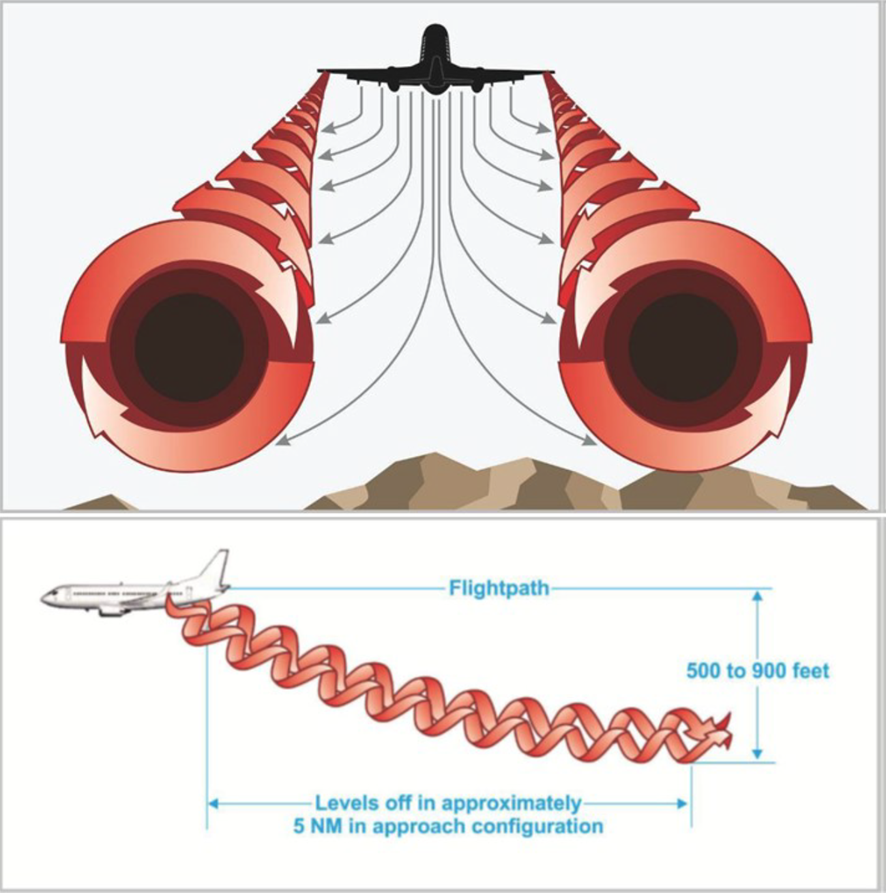
The aircraft operator assessed that the uncommanded roll experienced by the SA227 crew was the result of wake turbulence[2] (Figure 1) generated by the A320 that had departed ahead. The very stable atmospheric conditions at the time of the incident contributed to the wingtip vortices generated by the A320 remaining in the SA227’s flight path longer than would otherwise have been anticipated

Figure 1: Wake turbulence generation

Figure 1: Wake turbulence generation

How an aircraft generates wake turbulence in flight, with associated wingtip vortices

Source: FAA (Advisory Circular: Aircraft Wake Turbulence, AC No: 90-23G)

Wake turbulence

A recent ATSB study, Analysis of wake turbulence occurrences at Sydney Airport 2021-2016, a Bayesian analysis, explains that

To minimise the risk to safety associated with wake turbulence, air traffic control separates aircraft arriving or departing from an airport using wake turbulence separation standards. These are time and/or distance-based measures that limit the separation of leading and following aircraft and are designed to reduce the likelihood and severity of wake turbulence occurrences.

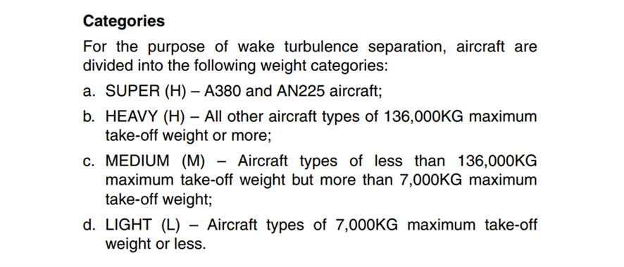
This separation is based on an aircraft’s maximum certified take-off weight, which is used to place it into a Light, Medium, Heavy, or Super wake turbulence category (Figure 2).

Figure 2: Division of aircraft categories based on maximum take-off weight

Division of aircraft categories based on maximum take-off weight

Source: Airservices Australia (Aeronautical Information Publications)

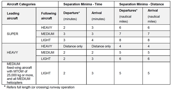
ATC applies the required distance and time separation requirements between aircraft based on which wake turbulence category each aircraft belongs to (Figure 3).

Figure 3: Table of required wake turbulence separation between categories

Table of required wake turbulence separation between categories

Source: ATSB (Analysis of Wake Turbulence Occurrences at Sydney Airport 2012-2016)

The SA227’s maximum take-off weight was 7,484 kg and the A320’s was 77,000 kg. Due to the broad range of weights included, both the SA227 and the A320 fall into the Medium wake turbulence category, and as a result ATC is not required to apply wake turbulence separation between them. Despite this, there is a significant difference in size and weight between these two aircraft types, and as such there exists the possibility of a wake turbulence encounter such as that experienced by the SA227 crew.

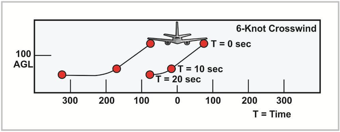
The stable atmospheric conditions on the day also contributed to this occurrence. Wingtip vortices generated by an aircraft are subject to local winds which can displace them from the position in which they are generated (Figure 4). The stable atmospheric conditions reported by the SA227 crew allowed the wingtip vortices to remain stationary behind the A320, and in the SA227’s projected flightpath, longer than would otherwise have been expected.

Figure 4: Effect of wind of wingtip vortices

Effect of wind of wingtip vortices

Source: FAA (Advisory Circular: Aircraft Wake Turbulence, AC No: 90-23G)

Safety action

The operator has advised the ATSB that a reminder of the hazards of wake turbulence will be included in a monthly safety newsletter and distributed to all flight crew.

Safety message

This incident serves as a reminder to flight crew of the hazards associated with wake turbulence, and the limitations of existing wake turbulence separation standards under some circumstances.

ATSB research has found that ‘wake turbulence separation standards will not completely eliminate the hazards associated with wake turbulence vortices’.[3] Therefore, pilots are reminded that existing wake turbulence separation standards may not provide adequate protection against wake turbulence encounters in circumstances of a large size differential between two aircraft within the same wake turbulence category.

About this report

Decisions regarding whether to conduct an investigation, and the scope of an investigation, are based on many factors, including the level of safety benefit likely to be obtained from an investigation. For this occurrence, no investigation has been conducted and the ATSB did not verify the accuracy of the information. A brief description has been written using information supplied in the notification and any follow-up information in order to produce a short summary report, and allow for greater industry awareness of potential safety issues and possible safety actions.

__________

  1. Western Standard Time (WST): Coordinated Universal Time (UTC) + 8 hours.
  2. Wake turbulence: Turbulence due to wakes behind large aircraft with a powerful downward motion.
  3. Analysis of Wake Turbulence Occurrences at Sydney Airport 2012-2016

Occurrence summary

Mode of transport Aviation
Occurrence ID AB-2021-011
Occurrence date 06/04/2021
Location near Perth Aerodrome,
State Western Australia
Occurrence class Serious Incident
Aviation occurrence category Turbulence/windshear/microburst
Brief release date 17/05/2021

Aircraft details

Manufacturer Fairchild Industries Inc
Sector Turboprop
Operation type Air Transport Low Capacity
Departure point Perth, Western Australia
Destination Forrestania, Western Australia
Damage Nil

Turbulence event involving a Cessna 182Q, near Texas Aerodrome, Queensland, on 24 January 2020

Brief

Occurrence Briefs are concise reports that detail the facts surrounding a transport safety occurrence, as received in the initial notification and any follow-up enquiries. They provide an opportunity to share safety messages in the absence of an investigation.

What happened

On 24 January 2020, a Cessna 182Q was conducting a private flight operating under visual flight rules from Warwick, Queensland, to Dubbo, New South Wales. The pilot was the only occupant on board. Forecast weather in the area at the time was low cloud and thunderstorms.

During cruise at 4,500 ft AMSL, the aircraft encountered severe turbulence at a speed above the aircraft’s turbulence penetration speed. The pilot conducted a climb and levelled off at 6,500 ft in an attempt to avoid further turbulence.

The pilot reported that the aircraft then encountered a severe updraft, resulting in a climb and change of heading of approximately 180° with little to no control of the aircraft. He began a descent to remain out of cloud. The pilot then descended through cloud to 3,500 ft and tracked away from the area, clear of any further cloud and turbulence. While attempting to turn back onto heading, the aircraft was struck by a severe downdraft followed by an updraft, resulting in another heading reversal of approximately 180°.

During the post-flight inspection at Dubbo, it was identified that both wings near the wing strut were bent and warped with visible deformation.

Safety message

This occurrence provides a reminder that pilots need to be aware of their aircraft’s performance and turbulence penetration speed as turbulence can be unpredictable. Should an aircraft encounter severe turbulence, pilots are reminded to reduce the speed of the aircraft to safely navigate through the turbulence in order to avoid potential damage or loss of control.

Further information can be found in the ATSB research report, Staying safe against in-flight turbulence (AR-2008-034).

About this report

Decisions regarding whether to conduct an investigation, and the scope of an investigation, are based on many factors, including the level of safety benefit likely to be obtained from an investigation. For this occurrence, no investigation has been conducted and the ATSB did not verify the accuracy of the information. A brief description has been written using information supplied in the notification and any follow-up information in order to produce a short summary report, and allow for greater industry awareness of potential safety issues and possible safety actions.

Occurrence summary

Mode of transport Aviation
Occurrence ID AB-2020-005
Occurrence date 24/01/2020
Location Near Texas Aerodrome
State Queensland
Occurrence class Accident
Aviation occurrence category Turbulence/windshear/microburst
Brief release date 03/04/2020

Aircraft details

Manufacturer Cessna Aircraft Company
Model 182Q
Sector Piston
Operation type General Aviation
Departure point Warwick, Queensland
Destination Dubbo, New South Wales
Damage Substantial

Severe turbulence involving de Havilland DHC-8, Dubbo, New South Wales, on 20 December 2018

Brief

Occurrence Briefs are concise reports that detail the facts surrounding a transport safety occurrence, as received in the initial notification and any follow-up enquiries. They provide an opportunity to share safety messages in the absence of an investigation.

What happened

On 20 December 2018, a de Havilland DHC-8 was traveling from Sydney, New South Wales (NSW) to Dubbo, NSW on a regular public transport flight. During approach to runway 23 at Dubbo, the aircraft encountered heavy showers and unexpected moderate to severe turbulence. The crew disengaged the autopilot and commenced a missed approach procedure. During the missed approach, the aircraft’s indicated airspeed (IAS) dropped to 100, and the crew received a momentary stick shaker alert. While climbing through 3,700 ft, the aircraft again encountered severe turbulence.

After landing, damage to the empennage was evident, with oil canning on the skin of the aircraft. Minor damage between the rudder and elevator was also observed. There were no reported injuries to passengers or crew; however, some passengers reported feeling airsick.

Safety message

The ATSB research report, Staying safe against in-flight turbulence (AR-2008-034), details that while turbulence is normal and occurs frequently, it can be dangerous. Turbulence is rarely a threat to passenger aircraft or to pilot control of the aircraft. In a typical turbulence incident, 99 per cent of people on board receive no injuries. The report outlines what steps passengers can take to mitigate the risk of injury during turbulence.

About this report

Decisions regarding whether to conduct an investigation, and the scope of an investigation, are based on many factors, including the level of safety benefit likely to be obtained from an investigation. For this occurrence, no investigation has been conducted and the ATSB did not verify the accuracy of the information. A brief description has been written using information supplied in the notification and any follow-up information in order to produce a short summary report, and allow for greater industry awareness of potential safety issues and possible safety actions.

Occurrence summary

Mode of transport Aviation
Occurrence ID AB-2018-134
Occurrence date 20/12/2018
Location Dubbo
State New South Wales
Occurrence class Serious Incident
Aviation occurrence category Turbulence/windshear/microburst
Highest injury level None
Brief release date 03/05/2019

Aircraft details

Manufacturer de Havilland Aircraft
Model DHC-8-202
Sector Turboprop
Operation type Air Transport High Capacity
Departure point Sydney, NSW
Destination Dubbo, NSW
Damage Minor