VH-LAP was cleared to track to Tea Tree (TTR) at 7000 feet.Approaching TTR, the aircraft was instructed to enter the holding pattern and shortly afterwards was cleared to descend to 4000 feet and to make an ILS approach for runway 12.Three minutes later, at 1812 hours, the pilot reported an ADF failure and asked for a climb.He was cleared to 5500 feet. He was then cleared to track outbound between the 301 and the 310 radials, and to turn inbound as required to establish the aircraft on the localiser at approximately 20 DME.He could then expect an ILS approach.
Over an extended period, the pilot tried to establish himself on the localiser, with assistance from the pilots of two other aircraft holding above, both of whom had VH-LAP in sight from time to time.Eventually another ILS was commenced but this was abandoned because the aircraft was too high (4500 feet at five miles from the aerodrome on final approach).
At the suggestion of the tower controller and with controller assistance a runway 30 VOR/DME was then successfully completed and the aircraft landed at 1859.
The pilot was using a GPS to establish distances, as he could not obtain distance readings from the international DME.Use of the GPS as a primary navigation aid was not permitted. The pilot had selected the Hobart ILS frequency on both the NAV selector and the international DME selector. The pilot thought the international DME selector was a second NAV selector.The number two NAV indicator, which the pilot thought was for a second NAV receiver, was in fact driven by the GPS.Hence the tracking indications on the two NAV indicators were different. Because of the pilot's misunderstanding over the purpose of the second indicator, the indication differences created confusion in his mind.
The ADF equipment was later established to have been operating normally and the reason for the pilot reporting it had failed was not determined.
Another company pilot was holding at TTR and attempted to pass advice to the pilot of VH-LAP.Recorded communications of the occurrence showed that the stream of instructions was considerable and may have contributed to overloading the pilot of VH-LAP.
Significant Factors
The following factors were considered relevant to the development of the incident:
The pilot was not adequately familiar with the navigation equipment fitted to the aircraft and hence became confused over the indications obtained.
The pilot had a low skill level in regard to orientating the aircraft to proceed on the localiser track.
The pilot reported that on final approach, he noticed that the runway surface appeared uneven and unsuitable for landing, so he conducted an overshoot. During this manoeuvre, the left main gear struck the ground or an object. The pilot retracted the landing gear and diverted to Horn Island. The left main gear collapsed on landing.
The runway at Badu Island had been closed for maintenance.
The strip and windsock were appropriately marked. Badu Island airstrip is not a licenced aerodrome and as such a NOTAM regarding works in progress was not issued. The local council reported that it notified the regular operators who serviced the island. However, the operator involved in this occurrence was not aware that the strip was closed.
On 3 September 2014, at about 0215 Eastern Standard Time (EST),[1] a Fairchild SA227 aircraft, registered VH-UUO, took off from Brisbane Airport, Queensland for a freight charter flight to Bankstown Airport, New South Wales, with one pilot on board. Following the take-off, when at about 200 ft above ground level, the pilot observed the horizontal situation indicator (HSI) indicating a right turn although the aircraft was still maintaining runway direction. The pilot reported that the attitude indicator (AI) displayed alternately a nose up and nose down attitude.
When at about 1,600 ft above ground level, the pilot advised air traffic control of a ‘minor problem with heading’ and was directed to conduct a right turn onto an easterly heading to avoid noise sensitive areas. The pilot turned the aircraft to the right, towards the Pacific Ocean, while referring to the HSI on the co-pilot’s instrument panel, which was providing more accurate heading information. The pilot was aware that the captain’s AI and HSI instruments were providing erroneous indications, but became disoriented by continuing to scan those instruments. The pilot looked out of the window in an attempt to gain a visual reference but could see only blackness.
The pilot continued a shallow right turn until the lights of runway 19 became visible. The aircraft landed back at Brisbane, on runway 19 about 150 kg above the aircraft’s maximum landing weight.
What the ATSB found
The ATSB found that the cockpit was not configured correctly prior to taxi, nor was the incorrect heading reference detected or corrected during the taxi or line up. The left gyro slaving switch was selected to ‘free’ instead of ‘slave’ mode, resulting in the captain’s HSI indicating about 50° left of actual heading throughout the flight.
The AI probably intermittently malfunctioned after take-off, and the pilot became distracted by the two erroneous instrument indications. These, combined with the dark night and flight over water without visual reference, contributed to the pilot’s difficulty in maintaining orientation and achieving the planned departure track. The pilot therefore elected to return to land at Brisbane.
What has been done as a result
The aircraft operator developed a simulator exercise based on the incident, to ensure all company pilots demonstrated limited instrument panel skills – without reference to attitude indicator or direction indicator, and troubleshooting skills.
Safety message
This incident highlights the importance of completing pre-flight checks and ensuring the cockpit is correctly configured prior to taxiing. Particularly when operating at night or into instrument meteorological conditions, it is imperative to verify all reference instruments are indicating correctly. This incident also highlights the importance of communication, especially as emergencies arise. If a pilot is having difficulty controlling an aircraft and maintaining instrument or visual reference, then alerting air traffic control enables them to provide the necessary and appropriate assistance.
[1] Eastern Standard Time (EST) was Coordinated Universal Time (UTC) + 10 hours.
On 10 January 2013, the crew of an Embraer Regional Jet 170 (E170), registered VH-ANO and operated by Airnorth, were flying from Darwin to McArthur River Mine, Northern Territory. Shortly after passing navigational waypoint SNOOD, 125 NM (232 km) north-west of McArthur River Mine, the aircraft’s flight path started diverging from its planned track. The problem was identified by air traffic control and the crew were advised. The aircraft was re-cleared direct to the initial approach fix and continued to McArthur River Mine.
What the ATSB found
The ATSB found that, while updating the aircraft’s flight management system for the descent into McArthur River Mine, the crew unintentionally omitted entering an intended navigational waypoint that was located 25 NM (46 km) north-west of McArthur River Mine. This omission resulted in the aircraft’s autopilot tracking the aircraft direct to the initial approach fix instead of first tracking to the intended waypoint. The crew’s crosschecking processes were not effective in identifying the data input error.
Although it could not be concluded as contributing to the crew’s errors, the ATSB also found that, due to restricted sleep in the previous 24 hours, the crew were probably experiencing a level of fatigue known to have a demonstrated effect on performance. Although the operator’s rostering practices were consistent with the existing regulatory requirements, it had limited processes in place to proactively manage its flight crew rosters and ensure that fatigue risk due to restricted sleep was effectively minimised.
What's been done as a result
Airnorth advised that since the occurrence, the number of E170 flight crew has been augmented, increasing its rostering flexibility. Furthermore, due to schedule changes, the operator no longer used any roster pattern that resulted in planned rosters with flight crews receiving less than 10 hours time off duty overnight.
Although not in response to this occurrence, the Civil Aviation Safety Authority has released revised fatigue management and flight and duty time requirements in Civil Aviation Order (CAO) 48.1 Instrument 2013. These new requirements either require operators to have a fatigue risk management system, or operate to more restrictive requirements regarding minimum time off duty than those which previously applied.
Safety message
This occurrence reinforces the importance of all pilots and operators conducting systematic and comprehensive checks of all data entered into flight management systems, and the importance of continually monitoring the effects of data input on an aircraft’s flight path.
On 1 December 2009 at approximately 0730 EST, the forward, left-side cargo door of a Eurocopter AS350D helicopter (registered VH-PIH) separated from the helicopter fuselage during fire-fighting operations near Maryborough, Queensland. The helicopter subsequently landed safely and there were no injuries.
It was probable that separation of the cargo door occurred as a consequence of replacement of the door seal during a recent overhaul. That replacement resulted in the door sitting proud of the mating surfaces when closed and latched. Elevated air loads acting on the door as a product of its overly proud position would subsequently have led to its fracture.
It was considered that the installation of improved door locks per Service Bulletin SB 52.00.25 and SB 52.00.26 would likely address this safety issue and significantly reduce the likelihood of a future AS350 cargo door separation event.
As a result of this occurrence the operator applied the cargo door lock modifications detailed in SB 52.00.25 and SB 52.00.26 to the new door installed on VH-PIH. In addition, the Australian Transport Safety Bureau has issued a Safety Advisory Notice to all operators of Eurocopter AS350 aircraft to consider the implications of the safety issue and take action where considered appropriate.
The report presented below was prepared principally from information supplied to the Bureau.
REPORTED INFORMATION
On 10 May 2005 at 0927 central standard time, the pilot of a Piper Aircraft Corporation PA-31-350 aircraft, registered VH-MZV, being operated on a charter flight from Snake Point, NT, landed short of the displaced threshold on runway 11 at Darwin International Airport.
Flight crews were notified of the displaced threshold in a notice to airmen (NOTAM) and on the Darwin automatic terminal information service (ATIS). The threshold was displaced 723 metres and indicated by bar V-markers and lights. The unusable section of runway was marked with three white crosses and red and white cones. The displaced threshold and markings were in accordance with Civil Aviation Safety Authority, Manual of Operating Standards Part 139- Aerodromes- Section 8.3.9.
The pilot reported that his turn onto final approach was lower than usual, as he was requested by air traffic control to conduct a close left base. The pilot did not see the white crosses and reported that the morning sun may have prevented him from seeing the displaced threshold markers.
The pilots landing clearance included advice that the threshold was displaced. The pilot was aware of an aircraft at the holding point and another conducting an instrument approach. The pilot decided to land using a short field landing procedure to facilitate the departure and arrival of the other aircraft, but this was not requested by the aerodrome controller (ADC). The pilots focus upon vacating the runway as soon as possible distracted him from landing beyond the displaced threshold.
After landing, he reported seeing the red and white cones ahead of the aircraft and was notified by the ADC that he had landed short of the displaced threshold.
The visual ground aids associated with the Stage 3 works were marked and located in accordance with the Civil Aviation Safety Authority (CASA) Manual of Standards Part 139 - Aerodromes and the CASA Manual of Operational Standards. The notice to airmen (NOTAM) relating to the Stage 3 works included details of the displacement of the threshold of runway 21 and its associated markings, and included information that the runway 21 glidepath was not available. It also included information about the location of the temporary precision approach path indicator (PAPI), and that that it would be set to Stage 2 intensity.
The crew of the Airbus were aware of the displaced threshold, but seemed uncertain about its extent. Their perception that the unserviceability cone-shaped markers were a line signifying the displaced threshold was probably heightened by the fact that it was beyond the area of runway surface that was marked by unserviceability crosses. Additionally, as no unserviceability crosses were located on the runway beyond that point, it may have led the crew to assume that the aircraft could be safely landed beyond the cone-shaped unserviceability markers, even though there were no V-bar markers on each side of the runway to indicate that was actually the case.
Glideslope guidance was available from the temporary PAPI. The fact that the aircraft landed short of the displaced threshold meant that the landing approach was below the correct approach slope to the touchdown point associated with the displaced threshold. That being so, the temporary PAPI should have provided appropriate visual cues to the crew that the aircraft was below the intended approach slope. It is likely that the crew did not notice the PAPI because they were uncertain about the exact location of the displaced threshold, and were therefore not looking far enough down the runway to notice the PAPI light beams. Additionally, the PAPI was only set to Stage 2 in fine, daylight, overcast conditions, when Stage 4 was the optimum setting for those conditions. Under those circumstances, the light beams emitted by the PAPI may have been inconspicuous to the crew and outside their area of concentration in attempting to determine the location of the displaced threshold.
In this occurrence, the temporarily displaced threshold markings and the light signals from the temporary PAPI on the Stage 2 setting, were not of sufficient salience to compete with the other visual inputs to the crew. Consequently, the crew inadvertently misidentified the position of the displaced threshold.
Appendix A: Stage 3 works at Perth Airport
Factual Information
At 0803 Western Standard Time on 24 April 2005, an Airbus Industrie A340-212 (Airbus) aircraft, registered ZS-SLA, with a crew of 11 and 219 passengers, landed short of the displaced threshold on runway 21 at Perth Airport, Western Australia. The aircraft was on a scheduled flight from Johannesburg, South Africa. The pilot in command was the handling pilot for the approach and landing at Perth.
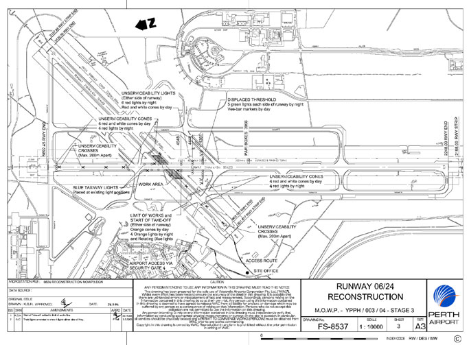
The displaced threshold was required during Stage 3 of works involving the reconstruction of runway 06/24 and taxiway intersections at Perth airport. On 1 December 2004, the airport operator issued Method of Working Plan (MOWP) YPPH 01/04 which described the proposed works. The MOWP was distributed to air operator users of Perth Airport, including the operator of the Airbus.
The MOWP provided information that Stage 3 works included reconstruction of the runway 03/21 intersection. The Stage 3 works were scheduled between 0130 and 0930 on each programmed workday. During the Stage 3 work periods, the threshold of runway 21 was displaced 1,331 m to the south, and the glidepath component of the runway 21 instrument landing system was not available. A temporary precision approach path indicator (PAPI) was also installed on the eastern side of runway 21 to provide visual guidance for a 3-degree approach to the touchdown zone for the displaced threshold. The temporary PAPI was 395 m to the south of the runway 21 displaced threshold. Refer to Appendix A for a diagram of the displaced threshold arrangements for Stage 3 of the works.
The PAPI system consisted of a bar of four light-emitting units adjacent to runway 21. Each unit of a PAPI system produces a light beam that is divided into an upper white and a lower red sector. A pilot sees the four individual lights in a combination of red and white depending on his vertical position in relation to the approach slope. If an aircraft is descending on the correct approach slope, a pilot will see red beams of light projected from the two inner boxes, and white beams projected from the two outer boxes. If the aircraft is too high in relation to the approach slope, the pilot will see white beams of light projected from all four boxes. Conversely, if the aircraft is too low in relation to the approach slope, the pilot will see red beams of light projected from all four boxes.
The MOWP included information that visual ground aids associated with the works would be supplied, marked, and located in accordance with the Civil Aviation Safety Authority (CASA) Manual of Standards Part 139 Aerodromes.
CASA also published a Manual of Operational Standards. Part 3 of that manual related to aerodromes, and included the following advice in the introductory material relating to the marking of displaced thresholds:
During a landing approach, a pilot attempts to create a standard approach situation using information from, among other things, cockpit instruments, glideslope guidance and runway aspect and markings. When a pilot sees the runway picture he/she expects to see during his/her scan of these inputs, any unobtrusive temporary markings outside his/her normal areas of concentration may not cue him sufficiently to make him react to them. Temporarily displaced threshold markings must compete with normal threshold markings, centreline markings, fixed distance and touchdown zone markings, visual glidepath information and all the other visual inputs which tend to guide a pilot to a touchdown zone close to the approach end of the visual runway. These existing cues must be disrupted and the temporary markings made obvious enough to direct the pilots attention to the displaced threshold.
Paragraph 3.3.1.1 of the CASA Manual of Operational Standards stated that temporarily displaced thresholds on runways that do not display permanent threshold markings shall be marked by V-bar markers on each side of the runway. During the Stage 3 works, four red and white cone-shaped unserviceability markers were placed over the threshold markings, and four red and white cone-shaped unserviceability markers were also placed across runway 21, immediately to the north of the intersection of taxiway D with runway 21. Four unserviceability crosses were placed on runway 21 between the permanent threshold and the intersection of taxiway D. Unserviceability crosses were also located adjacent to the runway between the intersection of taxiway D and the intersection of runway 06/24. The portion of runway 21 between the intersection of taxiway D and the displaced threshold was available for aircraft to taxi to the take-off point. That portion of the runway surface was not marked with unserviceability crosses. There were, however, unserviceability crosses adjacent to the shoulders of that portion of the runway.
The MOWP included details of the notice to airmen (NOTAM) to be issued for each stage of the works. The works safety officer was responsible for initiating the appropriate NOTAMs, through the Australian NOTAM Office, 48 hours before the commencement of a particular works stage. The Stage 3 NOTAM included details of the linear displacement of the threshold of runway 21, and that the displaced threshold would be marked by five green lights on either side of the runway and also with V-bar markers. The NOTAM included information that the runway 21 glidepath was not available. It also included information about the location of the temporary PAPI, that the temporary PAPI would be set to Stage 2 intensity, and that 5 minutes notice would be required to change the intensity of the PAPI. There were no requests made to alter the intensity of the PAPI setting during the aircrafts approach to runway 21.
The Airservices Australia Manual of Air Traffic Services contained information on the intensity of precision approach lighting systems. Stage 2 was the preferred initial selection for fine, night, overcast conditions. Stage 4 was the preferred initial selection for fine, day, overcast conditions, while Stage 6 was the preferred initial selection for bright, clear, day conditions.
The pre-flight NOTAM briefing package supplied to the crew of the Airbus before the departure from Johannesburg included the NOTAM relating to the Stage 3 runway 21 displaced threshold at Perth.
At about 4,000 ft during the descent into Perth, the air traffic controller cleared the crew to make a visual approach to runway 21. The crew subsequently reported that, although they were aware of the displaced threshold, they could not identify the displaced threshold markings during the approach. The crew asked the aerodrome controller to confirm the location of the displaced threshold, and the controller advised the crew that it was to the south of the intersection of runway 06/24. The pilot in command adjusted the approach flight path accordingly. The crew then observed what they perceived to be a transverse white line across the runway just to the north of the intersection of runway 06/24. Because the perceived line was close to the intersection of runway 06/24 referred to by the controller, the crew assumed the line to be the displaced threshold. The crew observed that the runway was clear of machinery and personnel, and the pilot in command landed the aircraft just past the perceived transverse line.
As the aircraft passed over the perceived line, and just before touchdown, the pilot in command saw that the perceived line consisted of cone-shaped unserviceability markers. The actual touchdown point of the aircraft was about 670 m short of the displaced threshold delineated by the V-bar markers on each side of the runway, and 1,065 m from the temporary PAPI touchdown area (refer Appendix A). The crew subsequently reported that at no stage during the approach did they see any other markings that delineated the displaced threshold. They also reported that they could not distinguish the V-bar markers referred to in the NOTAM.
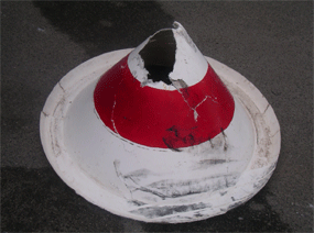
The aircraft ran over one of the red and white cone-shaped unserviceability markers during the landing (see figure 1). However, the aircraft was undamaged, and there was no other damage.
Figure 1: Damaged cone-shaped boundary marker
There was 10 km visibility at Perth at the time of the occurrence, with 7 oktas (7-eights of total sky visible to the celestial horizon) of stratocumulus cloud at 5,000 ft above mean sea level.
Two days after the occurrence, the aerodrome operator amended its procedure for daytime opening of the displaced threshold on runway 21. The amended procedure included a requirement for the temporary PAPI to be set to Stage 6 intensity when the runway lights were turned off at first light.
The ATSB received no other reports of aircraft landing short of the displaced threshold on runway 21 at Perth during the period in which the Stage 3 works were conducted.
Summary
At 0803 Western Standard Time on 24 April 2005, an Airbus Industrie A340-212 (Airbus) aircraft, registered ZS-SLA, with a crew of 11 and 219 passengers, landed short of the displaced threshold on runway 21 at Perth Airport, Western Australia. The aircraft was on a scheduled flight from Johannesburg, South Africa. The pilot in command was the handling pilot for the approach and landing at Perth.
Prior to the top of the descent, the crew of the Boeing 767 monitored the Perth Airport automatic terminal information service, which indicated low mist patches in the airport area. The approach controller indicated to the crew that fog was rapidly obscuring both runways. However, a short time later, the tower controller indicated that the visibility on runway 21 was 800 metres. At the minimum descent altitude, the crew reported to the tower controller that they could see the runway. The crew later reported that during the landing roll, visibility reduced to less than 600 metres. The aircraft landed at 2156 WST on runway 21.
The Bureau of Meteorology issued a terminal area forecast at 1838 which forecast a 30% probability of fog from 0200-0800 the next morning. An amended terminal area forecast was issued at 2045 which forecast a 40% probability of fog from 0000-0900 the next morning. The current airport trend type forecast indicated periods of reduced visibility to 4,000 metres for 30 minutes or less. The onset of fog occurred 2.5 hours prior to the forecast time.
A report from the Bureau of Meteorology Perth office indicated that the assessment was that fog would be a possibility depending on how quickly the showers and cloud cleared, the wind speed decreased and stabilisation of the dewpoint occurred. At 2040 a pilot landing at Jandakot Airport, about 16 kilometres from the Perth Airport, advised that fog patches were forming at that airport. At 2050 the duty Senior Supervising Meteorologist conducted a `rooftop' observation from the Regional Forecasting Centre and noted that the Perth control tower, about 12 kilometres, and lights on the Darling escarpment, about 19 kilometres, were visible. The observed conditions confirmed that fog from 0000 seemed a reasonable possibility. The Bureau of Meteorology indicated that experience had shown that it was rare for fog to occur as early as it had. The early occurrence of fog at Perth always follows precipitation in the preceding daylight hours. The passage of a front in the afternoon, accompanied by precipitation is a good precursor of early fog at Perth. The frontal passage was in the early evening at 1930. While fog can form almost immediately after a frontal passage, as it did on this occasion, experience has shown that it is rare for this to happen. The number of fogs forming at 2200 or earlier, over a 26 year period at Perth Airport is approximately 20 out of a total of 340 or 5% of occasions. The forecasting team on duty that night were surprised by the onset of fog, earlier than expected, once the showers had cleared.
The Bureau of Meteorology advised that the soon to be implemented Bureau of Meteorology Research Centre Fog Project at Perth Airport will assist with the knowledge and the quality of aviation fog forecasting.
As a result of this occurrence, the ATSB (formerly BASI) issued Safety Advisory Notice SAN19990083 concerning un-notified back beam radiation from a localiser. The safety deficiency noted that back beam radiation from a localiser may give false course indications if the navigation aid frequency is inadvertently selected for an approach.
There are no published procedures for the conduct of a precision approach using course guidance from a LLZ back beam. However, it is possible for an aircraft intercepting the back beam of the LLZ for runway 33 at Cairns (identifier ICN, frequency 109.5 MHz) when making a LLZ approach to runway 15 at Cairns (identifier ICS, frequency 109.9 MHz), if the incorrect approach aid frequency is manually selected. Other locations within Australia where similar localiser configurations exist may cause similar problems. Crews of advanced technology aircraft must exercise extreme caution in tuning and identifying navigation aids to ensure that the correct navigation aid frequency has been selected. Depending on the configuration of the selected navigation display mode, there may be insufficient cues displayed which would alert the crew that an incorrect navigation aid has been manually selected. Additionally, crews must ensure that Flight Management Systems are correctly programmed, and that a high level of situation awareness is exercised during the approach phase.
SAFETY ADVISORY NOTICE SAN 19990083
Operators, Airservices Australia, and the Civil Aviation Safety Authority should note the safety deficiency identified in this document and take appropriate action.
Local Safety Action by the operator
As a result of this occurrence the operator advised it had issued a notice to its flight crews that contained the following information:
"Caution during CS 15 ILS/LLZ DME Approach
A recent incident during a 15 ILS approach to Cairns revealed that if the R33 (sic) LLZ frequency is inadvertently selected in lieu of the 15 ILS frequency, the 33 LLZ is capable of transmitting a back beam that the aircraft may capture. Crews must exercise extreme caution tuning and identifying navigational aids to ensure the correct frequency has been selected. Depending on the configuration of the selected navigation display mode, there may be insufficient cues displayed which would alert the crew that an incorrect navigation aid has been manually selected. Additionally, crews must ensure that flight management systems are correctly programmed and that a high level of situational awareness is exercised during the approach phase."
Analysis
Both pilots incorrectly tuned the Cairns runway 33 localiser on 109.5 MHz instead of the runway 15 localiser on 109.9 MHz and subsequently misidentified the morse-code identifier. Their errors represented inadvertent failure to carry out routine and highly practised tasks. The crew had operated into Cairns the previous night and on that occasion the runway 15 localiser was not operating properly. On the night of the occurrence, although both pilots had the incorrect frequency selected for the runway 15 localiser, they incorrectly assumed the localiser was still experiencing service difficulties. This assumption arose because neither crew member was receiving a glideslope indication on his flight instruments. Also, the weather conditions in Cairns on the night of the occurrence indicated that a complete instrument approach would not be required. This situation resulted in a decreased level of vigilance by both crewmembers to the extent that they did not adequately cross-check that the correct localiser frequency had been set.
Summary
While conducting a flight between Brisbane and Cairns, the crew of Boeing 737 VH-TJJ were cleared to conduct a runway 15 instrument landing system (ILS) approach at Cairns. The clearance included a requirement for the aircraft to track to position UPOLO, 15 NM to the north-east of Cairns aerodrome, then via a 15 NM arc with reference to the Cairns distance measuring equipment (DME) beacon to intercept the runway 15 ILS instrument approach. The co-pilot was the handling pilot for the sector and approximately 20 minutes prior to UPOLO, he conducted the descent and approach crew briefing for the runway 15 ILS at Cairns.
The Cairns runway 15 ILS beacon radiates localiser and glideslope signals that permit aircraft to make precision instrument approaches onto the runway. These signals are radiated on frequency 109.9 MHz, and the frequency also radiates a morse-code identifier for the approach aid. The three-letter morse-code identifier for the runway 15 ILS at Cairns is ICS. The published approach procedure for the runway 15 ILS at Cairns permits descent in instrument meteorological conditions to a height of 311 ft above ground level.
Because the cloud base was reported to be at 2,500 ft at Cairns, both crew members considered it unnecessary to activate the marker beacon audio receiver switch on their respective audio selector panels. Additionally, both crew members did not set the reference altitude markers on their respective altimeters to the minimum descent altitude for instrument approach for runway 15.
Both pilots had been operating with their respective very high frequency (VHF) navigation control panels in the automatic setting mode, with tuning of VHF frequencies being automatically accomplished by the flight management computer. The pilot in command then incorrectly preset the manual frequency selector of his VHF navigation control panel to 109.5 MHz, the frequency for the runway 33 localiser at Cairns, morse-code identifier ICN. The co-pilot noted that 109.5 MHz was preset in the pilot in command's VHF navigation control panel. Assuming that this was the correct frequency for the runway 15 ILS, the co-pilot then preset 109.5 MHz into the manual frequency selector of his own VHF navigation control panel, but left the navigation control panel in the automatic setting mode. Both pilots reported that they incorrectly identified the morse-code ICN signal on frequency 109.5 MHz as ICS, the morse-code identifier for the runway 15 ILS on frequency 109.9 MHz.
The co-pilot programmed the flight management computer to fly the 15 DME arc from UPOLO to intercept the runway 15 ILS. Because the flight management computer was being used to intercept the ILS, the pilot in command selected the Cairns VOR, frequency 113.0 MHz, on the manual selector of his VHF navigation control panel. He then selected the MAP mode on his electronic horizontal situation indicator to monitor the aircraft flight path with raw data gained from reference to the ground-based Cairns VOR navigation aid. With the electronic horizontal situation indicator set to MAP mode, a plan view of the flight progress was displayed. The MAP mode consisted of a fixed aircraft symbol superimposed on a moving map background that could include destination/origin airports, flight plan route, and display of navigation aids in use at the time. The co-pilot had his electronic horizontal situation indicator set to MAP mode to monitor the autopilot's conduct of the 15 DME arc. He also armed the autopilot mode control panel to permit the autopilot to intercept the runway 15 ILS.
Shortly after passing position UPOLO, the co-pilot selected his navigation control panel to the manual setting mode. This was done to permit the presentation of navigation information from the 109.5 MHz approach navigation aid that the co-pilot had preset on his navigation control panel prior to the descent and which he incorrectly assumed was the frequency for the runway 15 ILS. After completing the 15 DME arc from UPOLO, the aircraft approached the localiser at 15 NM and at an altitude of 3,700 ft. The crew verified that the aircraft was on the runway 15 centreline by referring to the relative bearing of the Cairns non-directional beacon. The co-pilot's electronic horizontal situation indicator also indicated that the aircraft was on the extended centreline of Cairns runway 15. This information was displayed on the co-pilot's electronic horizontal situation indicator from the destination aerodrome data stored in the flight management computer. After confirming the aircraft was on the centreline for runway 15, the pilot in command then transferred his navigation control panel to 109.5 MHz. This resulted in both crewmembers having the incorrect approach aid tuned on their respective navigation control panels.
The flight mode annunciators on both crewmembers' electronic attitude direction indicators signified that the autopilot had captured the localiser. However, neither crewmember's electronic attitude direction indicator was displaying a glideslope pointer adjacent to the glideslope deviation scale. The crew sought and received confirmation from the Cairns aerodrome controller that the glidepath was operating normally. In the absence of any cockpit indication of the glideslope, the crew elected to continue the approach using the localiser for track guidance and the Cairns DME for descent guidance, in accordance with the published approach chart for runway 15. After checking the descent point from the approach chart, the co-pilot initiated descent by manual input into the autopilot mode control panel.
Shortly after descent had been initiated, both pilots noticed the aircraft commence a right turn away from the centreline of the localiser, and they elected to discontinue the approach. The pilot in command assumed control of the aircraft, disconnecting the autopilot and initiating a left turn away from the coast. At the same time, the controller, who had been observing the aircraft's approach on his radar screen and had noticed what he considered to be an unsafe flightpath deviation, immediately issued an instruction to the crew to turn left onto a heading of 110 degrees. When the controller was satisfied that the aircraft was clear of terrain, the crew was cleared to descend to 1,500 ft. After the crew reported visual, the controller cleared them to make a visual approach onto runway 15.
On the previous night the crew had operated a service to Cairns. On that occasion, the Cairns runway 15 ILS had been unserviceable and the crew received information about its unserviceability prior to their departure for Cairns. As a result, at the time of the occurrence, the crew suspected that the ILS may again have been experiencing service difficulties. The crew reported that this may have delayed their realisation that the incorrect frequency had been selected.
Jeppesen were advised of the ambiguity displayed on the chart and have since re-issued the chart to more accurately reflect the current amendments to the taxiway system in that part of the airport.
Summary
After a Boeing 747 had landed on runway 34L the crew was instructed to taxi via runway 25 and taxiway Yankee (Y). Jeppesen Sydney terminal chart 10-9, dated 18 December 1998, was used to provide taxi guidance to the crew. That chart depicted taxiways G3 and Y leading off to the north of runway 25. However, the chart was ambiguous in that there was another letter "Y" displayed to the south of runway 25. The crew interpreted taxiway G3 to be taxiway Y on the basis of that information. The crew subsequently turned the aircraft onto taxiway G3, which was closed. The aircraft was then stopped until cone markers and unserviceability lights, which marked taxiway G3, had been removed.
The taxiway system in that area of the airport had been undergoing significant changes. A Notice to Airmen (NOTAM) had been issued advising that taxiway G3 was only available during daylight hours. The end of daylight had occurred 29 minutes before the incident.