Lost/unsure of position

Lost/unsure of position involving a Cessna 310R, VH-JVO, Lake Raeside, Western Australia, on 29 September 1993

Summary

The aircraft was flying above an overcast cloud cover. Whilst tracking towards Leonora, the last NDB station fix was lost, and the pilot could not establish contact with Leonora NDB or any other stations to determine his position. The pilot was eventually able to fix his position and landed safely at Leonora. The pilot was not aware that the ADF equipment in the aircraft was not in good condition.

Occurrence summary

Investigation number 199303051
Occurrence date 29/09/1993
Location Lake Raeside
State Western Australia
Report release date 29/03/1994
Report status Final
Investigation type Occurrence Investigation
Investigation status Completed
Mode of transport Aviation
Aviation occurrence category Lost/unsure of position
Occurrence class Incident

Aircraft details

Manufacturer Cessna Aircraft Company
Model 310R
Registration VH-JVO
Sector Piston
Departure point Perth WA
Destination Leonora WA
Damage Nil

Lost/unsure of position involving a Cessna 172H, VH-KWG and Boeing 727-277, VH-ANB, Melbourne Aerodrome, Victoria, on 23 February 1997

Summary

The pilot of VH-KWG called Essendon tower saying words to the effect that "he was just down from Mildura, a bit short on fuel and requesting an approach to the airstrip on the left". The Essendon tower controller checked his radar screen and noted a primary return on a left base for runway 16 at Melbourne. The return was confirmed as being KWG. At the same time a B727, VH-ANB, was joining final for runway 16 approximately three miles behind KWG. The Essendon tower controller coordinated with the Melbourne tower controller to divert ANB to avoid a serious conflict on final approach. KWG was retained on Essendon tower frequency and cleared to land on runway 16 at Melbourne.

Investigation revealed that the pilot was from another state and not familiar with the area. He had planned a flight from Mildura to Wangaratta. He was using a portable GPS but its battery went flat during the flight and its DC power supply system was not working. Having lost GPS information, he tuned the aircraft's ADF to Wangaratta but did not check the morse code identifier. Furthermore, there were isolated thunderstorms in the area and the pilot had been diverting around cloud en route. He did not have an Enroute Supplement or an ERC Low or a WAC chart. He was carrying an ONC chart. He reported that he followed the ADF needle until he saw Melbourne Airport where he finally landed.

Occurrence summary

Investigation number 199700535
Occurrence date 23/02/1997
Location Melbourne Aerodrome
State Victoria
Report release date 25/02/1997
Report status Final
Investigation type Occurrence Investigation
Investigation status Completed
Mode of transport Aviation
Aviation occurrence category Lost/unsure of position
Occurrence class Incident

Aircraft details

Manufacturer Cessna Aircraft Company
Model 172H
Registration VH-KWG
Sector Piston
Operation type Private
Departure point Mildura Vic
Destination Wangaratta Vic
Damage Nil

Aircraft details

Manufacturer The Boeing Company
Model 727-277
Registration VH-ANB
Sector Jet
Operation type Air Transport High Capacity
Destination Melbourne Vic
Damage Nil

Lost/unsure of position involving a British Aerospace PLC BAe-125-700B, VH-JFT, Telfer Aerodrome, Western Australia, on 19 December 1995

Summary

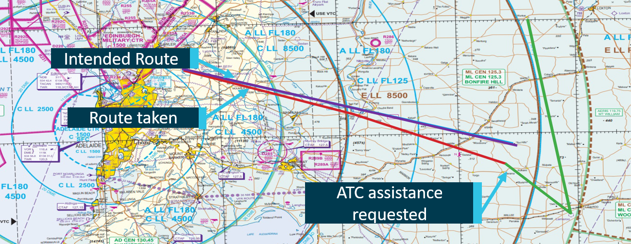
The flight was the first leg of a ferry flight from Australia to the United Kingdom. After passing Adelaide the crew were advised of a change in the weather, because of a cyclone, which meant that their planned destination required an alternate. They elected to change their destination to Broome and re-planned the flight to track via overhead Ayres Rock. Navigation for the flight was being conducted by reference to a global navigation system (GNS).

The crew did not attempt to confirm their Ayres Rock position by checking the Alice Springs navigation aids. Instead, they relied solely on the GNS readout. The GNS positions were not checked on the Ayres Rock - Broome leg because of a lack of ground-based navigation aids. Approaching Broome, as indicated by the GNS, the crew attempted to obtain a cross-check from the navigation aids at Curtin but were unable to obtain any useful information. The crew were also unable to obtain any information from the Broome navigation aids.

The pilot-in-command commenced an instrument descent into Broome using GNS information only. He became concerned after the aircraft had descended to 2,400 ft above mean sea level and the crew could not see the ground, the radio altimeter was indicating the aircraft was only 600 ft above ground level and they were unable to contact anyone using the VHF radio. The pilot-in-command declared an emergency, indicating that he was unsure of his position and that he had 30 min fuel remaining, before climbing the aircraft to 6,000 ft. During the next 45 min the crew, with the assistance of air traffic services and another aircraft, attempted to establish the aircraft's position without success. Eventually a passenger, using a portable global position system receiver which was held against a cabin window, was able to establish that the aircraft was 79 NM north of Telfer. Air traffic services activated the lights at Telfer aerodrome and the aircraft landed there with limited fuel remaining 65 min after the aircraft's original estimate for Broome.

An investigation determined that the planning and conduct of the flight was deficient in a number of areas and that these contributed to the occurrence. Some of the more significant areas were crew compliment, approval and use of global navigation systems and the continued operation of a jet aircraft at low level in a critical fuel situation.

The aircraft was certified for two pilot operation with both pilots endorsed on type. The co-pilot was not endorsed on type, he was not familiar with the aircraft's GNS equipment and had not been trained in its use.

It was considered likely that inaccurate information was inadvertently entered into the GNS after the decision to change the route and destination was made. As the pilot-in-command did not have a standard checking procedure for changes to GNS information, and the co-pilot was unfamiliar with the system, the errors went undetected.

The pilot-in-command's acceptance of GNS information only for route tracking and descent, when some ground aids were available to cross check the information, indicated a lack of understanding of the use of defences to improve the level of aviation safety and of Australian requirements for the use of GNS as the sole means of navigation.

The crew's inability to establish contact with a ground-based navigation aids and VHF radio stations after the descent was probably a function of the aircraft's altitude and distance from them. In addition, operations at low level in jet aircraft are inefficient as far as fuel usage is concerned. In remaining at low level for over 45 min the pilot-in-command exhibited a lack of understanding of communication and aircraft operational limitations.

Occurrence summary

Investigation number 199504306
Occurrence date 19/12/1995
Location Telfer Aerodrome
State Western Australia
Report release date 05/02/1996
Report status Final
Investigation type Occurrence Investigation
Investigation status Completed
Mode of transport Aviation
Aviation occurrence category Lost/unsure of position
Occurrence class Incident

Aircraft details

Manufacturer British Aerospace
Model BAe-125-700B
Registration VH-JFT
Sector Jet
Operation type General Aviation
Departure point Essendon VIC
Destination Broome WA
Damage Nil

Navigation event involving a Saab 340B, VH-TRX, 11 km south-south-west of Williamtown Airport, New South Wales, on 8 November 2012

Final report

What happened

On the evening of 8 November 2012, the crew of a Regional Express Saab Aircraft Co. 340B, registered VH-TRX, were conducting a scheduled passenger flight from Sydney to Williamtown (Newcastle Airport), New South Wales, under the instrument flight rules.

After the crew reported on descent to Williamtown, the aircraft was cleared by the approach controller for a visual approach via a right base to runway 12. At 10 NM (19 km) south of Williamtown, the crew transferred to the aerodrome controller. Instead of tracking toward Williamtown as anticipated, the controller observed the aircraft manoeuvring at a greater distance than usual from the runway and advised the crew of their position. The crew then requested radar guidance and were directed toward the airport.

The crew visually identified runway 12 and landed the aircraft about 14 minutes before last light. After landing the crew advised the controller that they were unfamiliar with locating the airport at night.

What the ATSB found

The ATSB found that, in the low light conditions, the captain misidentified a coal loading and storage facility, 6 NM (11 km) south-west of Williamtown, as the airport environment.

What's been done as a result

Following an internal investigation, Regional Express alerted its crews to the possible misidentification of features in the Williamtown area and reminded them of the importance of using navigation equipment to verify their position. In addition, crews were advised that visual approaches were no longer to be conducted at Williamtown during normal operations and additional material on situation awareness and assertiveness skills was also incorporated into existing human factors and non-technical skills training.

The Williamtown air traffic control unit reminded its controllers of the need to provide assertive safety alert instructions, including the provision of minimum sector altitudes and prompt position information to aircraft that deviated from a cleared route, or whose observed position differed from that reported.

Safety message

This occurrence highlights the possibility of crews misidentifying ground features for the airport environment during visual approaches, especially in conditions of poor light. To avoid misleading visual cues during visual approaches, crews should confirm that they have correctly identified and are tracking to the intended destination by crosschecking with the aircraft’s navigation equipment.

Occurrence summary

Investigation number AO-2012-153
Occurrence date 08/11/2012
Location Williamtown Airport
State New South Wales
Report release date 13/03/2015
Report status Final
Investigation level Systemic
Investigation type Occurrence Investigation
Investigation status Completed
Mode of transport Aviation
Aviation occurrence category Lost/unsure of position
Occurrence class Incident
Highest injury level None

Aircraft details

Manufacturer Saab Aircraft Co.
Model 340
Registration VH-TRX
Serial number 340B-287
Aircraft operator Regional Express
Sector Turboprop
Operation type Air Transport Low Capacity
Departure point Sydney, NSW
Destination Williamtown, NSW
Damage Nil

Cessna 182G, 26 km NE of Boyup Brook WA, 23 May 1987

Summary

The pilot was conducting a parachute drop from 9000 feet. She reported that the cloud base was broken at about 4500 feet and that she climbed the aircraft through a break in the cloud cover to reach the drop altitude. After the parachutist had exited the aircraft the pilot found a break in the cloud cover and descended. However, she was then unable to locate the airstrip and spent some time flying in various directions until she decided to land and ascertain her location. A paddock was selected and after an aerial inspection a landing approach was conducted. The aircraft touched down about 150 metres into the paddock in tailwind conditions. It then ran through a fence, across a road and struck another fence before the nosegear leg collapsed. The aircraft then nosed over and came to rest inverted. The accident site is located about 47 kilometres south-west of the Hillman Farm Airstrip. After descending below the cloud base the pilot's reported actions did not include basic procedures when lost. She advised that when she could not establish her position, she became confused and apprehensive and consequently picked an unsuitably short paddock in which to land. The pilot had only recently recommenced flying after a 3 year break, and had completed a biennial flight review prior to conducting these parachute drops. Although this review totalled almost 6 hours flying and covered many important sequences, the instructor did not appreciate that the pilot had no cross-country experience in at-least that time. Navigation techniques and basic actions if lost were not covered in the review.

Occurrence summary

Investigation number 198700100
Occurrence date 23/05/1987
Location 26 km NE of Boyup Brook
Report release date 18/09/1987
Report status Final
Investigation type Occurrence Investigation
Investigation status Completed
Mode of transport Aviation
Aviation occurrence category Lost/unsure of position
Occurrence class Accident
Highest injury level Minor

Aircraft details

Manufacturer Cessna Aircraft Company
Model 182
Registration VH-DGI
Serial number 18255759
Operation type Private
Departure point Hillman Farm WA
Destination Hillman Farm WA
Damage Substantial

Cessna 210N, Lake Neale, Northern Territory

Summary

The pilot was conducting a night freight operation, carrying newspapers from Darwin to Alice Springs via Tindal and Tennant Creek. The flight from Darwin to Tindal was uneventful and the aircraft subsequently departed Tindal at 0219 am local time.

On departure, the pilot reported that he mistakenly established the aircraft on a track 30 degrees right of the correct track. After the pilot had levelled the aircraft at the intended cruising altitude, he fell asleep. As the flight progressed, the pilot occasionally woke up and made slight corrections to the heading, but he did not identify the 30 degree error. When the pilot realised that he should be on descent to Tennant Creek, he selected the appropriate frequencies, however the aircraft's navigation instruments did not provide any directional information. Believing that the aircraft was west of Tennant Creek, the pilot turned the aircraft and flew east, climbing to 14000 ft in an attempt to improve the range of the aircraft's navigation instruments. The instruments still did not show where Tennant Creek was, so the pilot decided to continue to Alice Springs at his flight planned altitude. At the time that the aircraft should have been approaching Alice Springs, the pilot selected the appropriate frequencies for the Alice Springs navigation aids. The aircraft's navigation instruments did not indicate the direction of Alice Springs, even though the pilot again climbed the aircraft to 14000 ft. The pilot reported that as the aircraft was now running low on fuel, the pilot decided to conduct a precautionary search and landing. The pilot advised Adelaide Flight Service on high frequency radio that he intended to land the aircraft on a dry salt lake.

The aircraft sustained minor damage during the landing however the pilot was not injured. He then activated the Emergency Locater Transmitter, and the aircraft was subsequently located 370 km WSW of Alice Springs. The company reported that its roster for night freight pilots has operated satisfactorily for around four years, with no reported serious fatigue problems. The pilots usually operate a one night shift every eight days, and the three days before the night shift are either days off or standby days. The pilot involved in this incident had done no flying on his rostered standby day, and therefore had had three full days off prior to signing on late in the evening of the day before the accident. He stated that he normally tried to sleep in on the morning before the night shift, and then get a couple of hours sleep in the afternoon. However, on the morning before he signed on for the night flight he was unable to sleep in and was then also unable to sleep in the afternoon. Consequently, by the time he signed on for the flight, the pilot had been awake for approximately 13.5 hours. The aircraft was not equipped with GPS. It is probable that the pilot's lack of sleep prior to signing on for the flight resulted in an increased level of fatigue. The increased fatigue may have contributed to the pilot selecting the incorrect heading on departure from Tindal and his subsequent lapses into sleep. Once the aircraft was out of range of the Tennant Creek and Alice Springs navigation aids and because of the lack of terrain features visible at night, there was no information available to the pilot to help him identify his position. The company is currently ensuring that flight crews have access to GPS equipment. The company is also drafting detailed standard operating procedures regarding sleep management, and these procedures will be included in the operations manual.

Occurrence summary

Investigation number 199901850
Occurrence date 20/04/1999
Location Lakr Neale
State Northern Territory
Report release date 01/05/2000
Report status Final
Investigation type Occurrence Investigation
Investigation status Completed
Mode of transport Aviation
Aviation occurrence category Lost/unsure of position
Occurrence class Incident
Highest injury level None

Aircraft details

Manufacturer Cessna Aircraft Company
Model 210
Registration VH-NQP
Sector Piston
Operation type Charter
Departure point Tindal NT
Destination Tennant Creek NT
Damage Nil

Request for navigational assistance involving a Piper PA-28-181, near Scone Airport, New South Wales, on 3 May 2020

Brief

Occurrence Briefs are concise reports that detail the facts surrounding a transport safety occurrence, as received in the initial notification and any follow-up enquiries. They provide an opportunity to share safety messages in the absence of an investigation.

What happened

On 3 May 2020 at about 1400 Eastern Standard Time, a solo student pilot was conducting a navigation exercise in a Piper PA-28-181 in the vicinity of Scone, New South Wales. The pilot became unsure of the aircraft’s position when he was unable to identify Scone Airport and followed the lost procedure, contacting air traffic control (ATC) for assistance.

As there was poor VHF reception with the aircraft, two other aircraft in the area provided navigational assistance and relayed instructions between ATC and the pilot of the Piper PA-28-181. ATC requested the aircraft climb to 7,500 ft in an attempt to be identified by radar. Once the aircraft was identified, ATC then provided a heading for Scone Airport and the aircraft proceeded without further incident.

Following the flight, the instructor conducted a two-hour incident debrief with the student pilot. The student will undertake further map reading training to ensure proficiency in this area prior to his next flight.

Safety message

This incident highlights the importance of remaining calm and remembering procedures in the face of uncertainty. If a pilot is unsure of the aircraft’s location, ATC is able to assist with locating positions using transponder codes, prominent landmarks and radio navigation.

In this incident, the further assistance provided by aircraft in the vicinity ensured a positive outcome.

About this report

Decisions regarding whether to conduct an investigation, and the scope of an investigation, are based on many factors, including the level of safety benefit likely to be obtained from an investigation. For this occurrence, no investigation has been conducted and the ATSB did not verify the accuracy of the information. A brief description has been written using information supplied in the notification and any follow-up information in order to produce a short summary report, and allow for greater industry awareness of potential safety issues and possible safety actions.

Occurrence summary

Mode of transport Aviation
Occurrence ID AB-2020-020
Occurrence date 03/05/2020
Location Near Scone
State New South Wales
Occurrence class Incident
Aviation occurrence category Lost/unsure of position
Highest injury level None
Brief release date 05/06/2020

Aircraft details

Manufacturer Piper Aircraft Corp
Model PA-28-181
Sector Piston
Operation type Flying Training
Departure point Scone Airport, New South Wales
Destination Scone Airport, New South Wales
Damage Nil

Lost/unsure of position involving Diamond DA 40, Lameroo, South Australia, on 9 May 2018

Brief

Occurrence Briefs are concise reports that detail the facts surrounding a transport safety occurrence, as received in the initial notification and any follow-up enquiries. They provide an opportunity to share safety messages in the absence of an investigation.

What happened

On 9 May 2018, around 1150 Central Standard Time, the pilot of a Diamond DA 40 departed from Parafield South Australia (SA) on a solo-training visual flight rules (VFR) navigation exercise. The pilot planned to fly from South Para Reserve to Tori Hills, SA. As the flight progressed, the pilot lost directional awareness and subsequently conducted the 1 in 60-correction tracking [1] in the wrong direction taking the aircraft off course. The pilot then followed the operator’s lost procedure and contacted Air Traffic Control (ATC) for assistance. ATC directed the aircraft to Lameroo Aerodrome and from there the pilot was able to continue on the rest of the navigation without assistance.

Figure 1: Map of Area

Figure 1: Map of Area. Source: Airservices Australia

Source: Airservices Australia

Safety action

As a result of this occurrence, the operator has advised the ATSB that they have taken the following safety actions:

  • The trainee pilot conducted a dual sortie involving a more complex lost procedure.
  • The operator held discussions on the use of the Global Navigation Satellite System (GNSS) as an aid in visual flying.

Safety message

This incident highlights the importance of requesting assistance from ATC when flight crew are unsure of the aircraft’s position. ATC are able to assist crew in locating positions using transponder codes, prominent landmarks and radio navigation. It is better to ask for assistance before fuel reserves are compromised.

__________

  1. A basic rule of thumb, which states that if a pilot has travelled sixty miles then an error in track of one mile is approximately a 1° error in heading. Utilised by single pilots with many other tasks to perform, often in a basic aircraft without the aid of an autopilot.

Occurrence summary

Mode of transport Aviation
Occurrence ID AB-2018-067
Occurrence date 09/05/2018
Location 34 km WSW of Lameroo
State South Australia
Occurrence class Incident
Aviation occurrence category Lost/unsure of position
Highest injury level None
Brief release date 13/11/2018

Aircraft details

Manufacturer Diamond Aircraft Industries
Model DA 40
Sector Piston
Operation type Flying Training
Departure point Parafield, SA
Damage Nil