

Preliminary report
Report release date: 13/11/2026
| The ATSB has released this preliminary report to provide a timely update on evidence gathered and investigation activities to date. It outlines areas of further investigation but does not contain analysis or findings, which will be detailed in a final report at the conclusion of the investigation. The information in this report is released in accordance with section 25 of the Transport Safety Investigation Act 2003. |
The occurrence
On 25 August 2026, at about 0700 local time, a pilot arrived at the Air Frontier hangar at Gove Airport, Northern Territory, to prepare for a return flight between Gove and Numbulwar, Northern Territory. At about 0800, the pilot requested that the operator’s Beechcraft 58 Baron, registered VH-AKH, be fully fuelled in preparation for the flight. Records indicated this was completed at 0855. At about 0909, the pilot lodged a flight plan through Airservices Australia for a direct flight between Gove and Numbulwar to be conducted at a cruising altitude of 4,500 ft, with only the pilot on board. The flight plan for the return to Gove indicated 4 passengers were to be on board.
At about 1052, the pilot taxied the aircraft to the northern end of runway 13 in preparation for departure. The pilot’s radio transmissions were recorded on the Gove common traffic advisory frequency (CTAF). The transmissions indicated that they commenced the take‑off roll at 1057, and by 1100 had departed Gove Airport on a southbound track to Numbulwar, climbing through 2,500 ft to their planned cruising altitude.
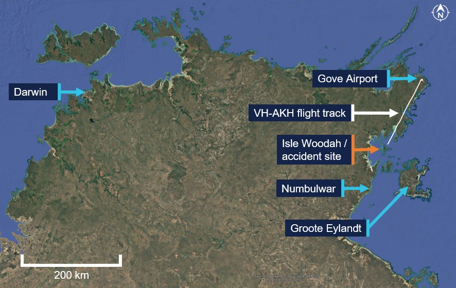
Around 1127, the aircraft was observed by recreational fishermen who were at anchor approximately 1 km south-west of Isle Woodah (Figure 1). They reported observing the underside of the aircraft as it passed and recalled hearing the noise of the aircraft becoming louder, which they associated with engine operation at high revolutions per minute. The witnesses observed the aircraft descending toward the water at an estimated 35–45° nose down attitude with its wings-level. They expected the aircraft to pull-up, however, it did not change trajectory, and it impacted the water at very high speed. The witnesses motored to the impact point and found a fuel/oil slick on the water surface along with many small floating fragments of shattered airframe. The pilot sustained fatal injuries.
Figure 1: VH-AKH flight track and accident site
Context
Pilot information
The pilot held a Commercial Pilot Licence (Aeroplane) and valid class 1 aviation medical certificate. They held the required class rating and endorsements to operate the Beechcraft 58 Baron aircraft. The pilot completed a multi-engine instrument proficiency check in July 2026. The operator’s records showed that, prior to the accident flight, the pilot had logged around 1,138 hours total flight time, of which 304.9 hours were in the Baron.
The pilot commenced employment with Air Frontier in May 2025. They passed a company line check in October 2025 and had operated from the Gove base since mid‑November 2025. The pilot was subsequently appointed as the senior base pilot for the Arnhem region in April 2026.
Aircraft information
The Beech Aircraft Corp (Beechcraft) 58 Baron is a twin-engine, low-wing, retractable tricycle landing gear aircraft. It is powered by 2 Teledyne-continental IO-520 fuel‑injected, horizontally opposed piston engines each driving a 3-blade variable‑pitch propeller. The aircraft held a total fuel capacity of 756 L.
The accident aircraft, serial number TH-972, was manufactured in the United States in 1978 and was first registered in Australia in November 1978. The aircraft logbooks indicated that the registration details changed in September 2015 to VH-AKH at 4,474 hours total time-in-service, after which Air Frontier operated the aircraft.
The most recent periodic inspection of the aircraft was completed in Darwin on 10 June 2026 and a maintenance release was issued at 7,302.0 hours total time‑in‑service. The aircraft had accrued another 79.8 hours service up until the morning of the accident.
Meteorological information
The Bureau of Meteorology maintained automatic weather observation stations at Gove and Groote Eylandt (61 km from the accident site). The weather recorded at Groote Eylandt around the time of the accident identified that the wind was coming from the east at 13 kt, with greater than 10 km of visibility, and the temperature was 30°C and dewpoint was 16°C. No cloud was detected.
A satellite image overhead the Northern Territory was also provided by the Bureau of Meteorology that was valid for 1130 on 25 August 2026. The image showed no significant cloud or weather activity in the region of the accident site.
These observations were consistent with the reports from the witnesses, and the other pilots operating in the region.
Recorded information
Flight data
The aircraft was not fitted with, nor was it required to have, a flight data recorder or cockpit voice recorder. Automatic dependent surveillance–broadcast data for the accident flight was not available. The last identified data was broadcast on 13 April 2026. Airservices Australia advised the ATSB that the aircraft had not been detected by radar for the accident flight.
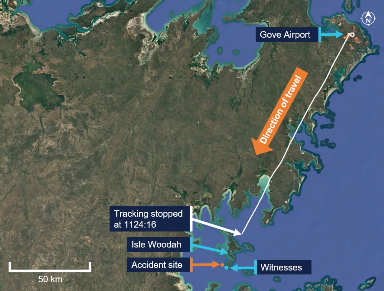
In-flight, the pilot was using an iPad with OzRunways, which used a cellular service to transmit flight tracking data to the provider. The OzRunways data showed (Figure 2):
- at 1057:59, the flight tracking commenced during the take-off roll and the aircraft became airborne at 1058:14
- at about 1102, the aircraft reached top-of-climb at an altitude of 4,700 ft, while tracking 208° (south-south-west)
- the aircraft remained tracking south-south-west in cruise, with the altitude ranging between 4,500–5,000 ft and ground speed of 181–203 kt
- the last data point was recorded at 1124:16, approximately 12 NM (23 km) north‑north-east of the impact point, when the aircraft was at an altitude of 4,800 ft and a ground speed of 193 kt.
Figure 2: VH-AKH flight track
Radio broadcasts
Examination of the CTAF radio transmissions recorded on 25 August 2026 for Gove, Numbulwar and Groote Eylandt identified 2 radio calls made by the pilot at Gove:
- At 1057:26, the pilot made a call during taxi for departure.
- At 1100:03, the pilot made a departure call, while climbing after take-off.
The planned track for the flight between Gove and Numbulwar was over a remote coastal section of the Northern Territory. No additional recorded CTAF transmissions regarding the operation of the flight were identified.
Mobile phone records
Prior to, and throughout the accident flight, telecommunication records identified that the pilot had maintained a messaging stream with their partner. The records identified that the final message was sent from the pilot at 1121 while the aircraft was in the cruise.
Wreckage examination
An air and surface search was conducted by the search and rescue authority and Northern Territory Police Force from 25–29 August 2026. The police reported that floating aircraft debris was located over a broad sea area consistent with their drift modelling. On 27 August 2026, police divers used vessel sonar to identify a debris field on the sea floor comprising heavily fragmented aircraft wreckage at a water depth of 17 m, about 3.5 km south-west of Isle Woodah.
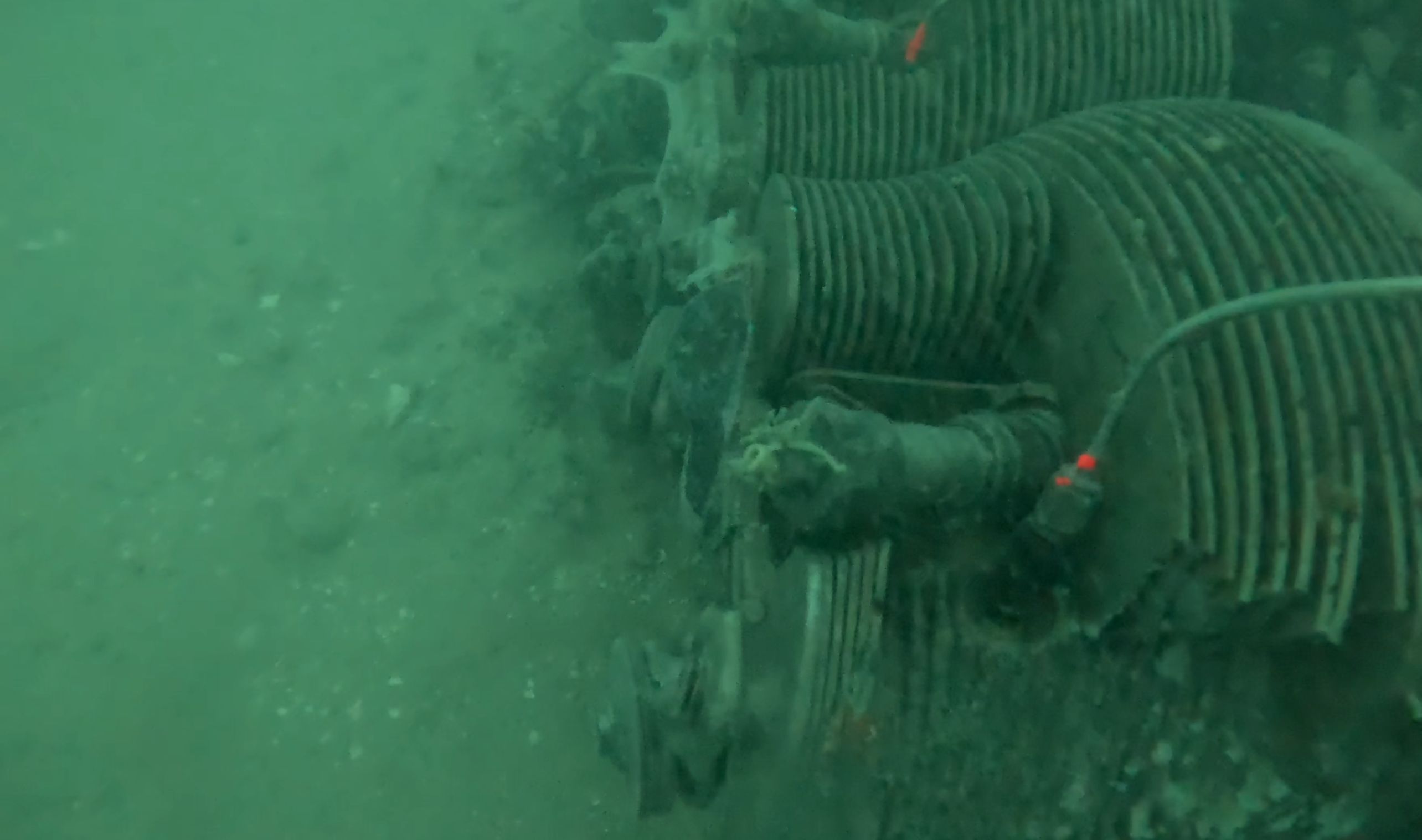
The police completed diving operations through 27–29 August 2026 and recovered some aircraft items from the sea floor. The diving confirmed the aircraft had separated into many large and small fragments, with that damage consistent with witness reports of a high velocity impact into the water. Many of the heavier items had embedded into the sea floor (Figure 3). The pilot’s personal logbook, their flight crew licence and a significantly damaged iPad were recovered. The divers identified the following major sections:
- an engine
- part of the vertical stabiliser
- a mid-rear part of the fuselage
- the cockpit area
- sections of wing.
Figure 3: One of the engines (cylinders shown) was found during police diving at the accident site
Further investigation
To date, the ATSB has:
- interviewed witnesses and involved parties
- obtained pilot and aircraft documentation
- analysed the available recorded data
- reviewed recorded audio transmissions and video footage at Gove Airport
- analysed Northern Territory Police diver footage of the wreckage at the accident site.
The investigation is continuing and will include further examination of:
- aircraft maintenance records
- operational and pilot documentation
- aircraft components and other items recovered from the aircraft
- similar occurrences.
A final report will be released at the conclusion of the investigation. Should a critical safety issue be identified during the course of the investigation, the ATSB will immediately notify relevant parties so appropriate and timely safety action can be taken.
Acknowledgements
The ATSB would like to acknowledge the assistance of the Northern Territory Police Force during the conduct of the search and rescue and diving activities.
Purpose of safety investigationsThe objective of an ATSB safety investigation is to improve transport safety through:
In accordance with the TSI Act, the ATSB does not investigate for the purpose of taking administrative, regulatory or criminal action, and cannot apportion blame, assist in determining liability, or, as a general rule, assist in court proceedings. About ATSB reportsATSB safety investigation reports are developed in accordance with ATSB procedures and guidelines, and with regard to applicable international standards and instruments. Reports must include factual material of sufficient weight to support the investigation’s analysis and findings. At all times the ATSB endeavours to balance the use of material that could imply adverse comment with the need to properly explain what happened, and why, in a fair and unbiased manner. An explanation of terminology used in ATSB investigation reports is available here. Publishing informationReleased in accordance with section 25 of the Transport Safety Investigation Act 2003 Published by: Australian Transport Safety Bureau © Commonwealth of Australia 2026 Ownership of intellectual property rights in this publication Unless otherwise noted, copyright (and any other intellectual property rights, if any) in this report publication is owned by the Commonwealth of Australia. Creative Commons licence 
With the exception of the Commonwealth Coat of Arms, ATSB logo, and photos and graphics in which a third party holds copyright, this report is licensed under a Creative Commons Attribution 4.0 International licence. The CC BY 4.0 licence enables you to distribute, remix, adapt, and build upon our material in any medium or format, so long as attribution is given to the Australian Transport Safety Bureau. Copyright in material obtained from other agencies, private individuals or organisations, belongs to those agencies, individuals or organisations. Where you wish to use their material, you will need to contact them directly. |
- ^ Runway number: the number represents the magnetic heading of the runway. The runway identification may include L, R or C as required for left, right or centre.
- ^ A designated frequency on which pilots make positional broadcasts when operating in the vicinity of a non-controlled aerodrome or with a broadcast area.
- ^ Dewpoint: the temperature at which water vapour in the air starts to condense as the air cools. It is used, among other things, to monitor the risk of aircraft carburettor icing or the likelihood of fog.
^ The satellite image processed by the Bureau of Meteorology was from the geostationary meteorological satellite
Himawari-8 that was operated by the Japan Meteorological Agency.
- ^ Automatic dependent surveillance–broadcast is a surveillance technology in which an aircraft determines its position via satellite navigation and periodically broadcasts it, enabling it to be tracked.
- ^ An electronic flight bag application that provides navigation, weather, area briefings, and other flight information. It provides the option for live flight tracking by transmitting the device’s position and altitude.
Occurrence summary
| Investigation number | AO-2026-094 |
|---|---|
| Occurrence date | 25/08/2026 |
| Occurrence time and timezone | 1127 Australian Central Standard Time |
| Location | 61 km north-west of Groote Eylandt Airport |
| State | Northern Territory |
| Report release date | 13/11/2026 |
| Report status | Preliminary |
| Anticipated completion | Q1 2027 |
| Investigation level | Short |
| Investigation type | Occurrence Investigation |
| Investigation phase | Examination and analysis |
| Investigation status | Active |
| Mode of transport | Aviation |
| Aviation occurrence category | Collision with terrain |
| Occurrence class | Accident |
| Highest injury level | Fatal |
Aircraft details
| Manufacturer | Beech Aircraft Corp |
|---|---|
| Model | 58 |
| Registration | VH-AKH |
| Serial number | TH-972 |
| Aircraft operator | Air Frontier Pty Ltd |
| Sector | Piston |
| Operation type | Part 91 General operating and flight rules |
| Activity | General aviation / Recreational-Other general aviation flying-Ferry flights |
| Departure point | Gove Airport, Northern Territory |
| Destination | Numbulwar Airport, Northern Territory |
| Injuries | Crew - 1 (fatal) |
| Damage | Destroyed |