
Report release date: 18/06/2026
| Occurrence Briefs are concise reports that detail the facts surrounding a transport safety occurrence, as received in the initial notification and any follow-up enquiries. They provide an opportunity to share safety messages in the absence of an investigation. Because occurrence briefs are not investigations under the Transport Safety Investigation Act 2003, the information in them is de-identified. |
What happened
On 25 May 2026, a pilot planned to conduct a multi-leg private flight with 2 passengers on board. The flight was to be conducted under the visual flight rules (VFR)1 in a Cessna 182. In the morning, the pilot filed a flight plan using an electronic flight bag2 with the final planned destination being Wilmington Airpark, South Australia. Prior to and throughout the trip, the pilot accessed weather forecast information using a third-party weather briefing application.
After arriving at Cadney Homestead aircraft landing area (ALA) for the final refuelling stop, the pilot reviewed a weather briefing for Port Augusta Airport, located approximately 25 NM (46 km) to the west of Wilmington Airpark. The weather information at the time indicated broken cloud cover3 at 2,000 ft with showers in the area and the pilot identified a last light4 time of 1735 local time. The pilot estimated that the time of arrival would be close, but prior to last light.
While en route through the Woomera area, the pilot began to alter the aircraft’s track south to avoid light showers in the region. At approximately 1658, the pilot observed deteriorating weather conditions and a darkening sky ahead and made contact via phone to a friend at Wilmington to obtain local weather conditions. The friend reported that at the time, conditions north of Wilmington were clear and visibility was good, so the pilot continued as planned.
At 1721, as the aircraft approached closer to the western side of the Flinders Ranges (Figure 1), the weather continued to deteriorate and the pilot again contacted the friend for an update on local conditions. This time, the friend reported that the cloud had moved over the range and visibility at Wilmington had significantly reduced, suggesting a diversion to an alternate airfield.
Figure 1: Southern Flinders Ranges area
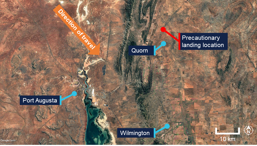
Source: Google Earth, annotated by the ATSB
The pilot identified Quorn ALA as the closest suitable alternate and began tracking east over the Flinders Ranges. During the diversion, the weather conditions encountered required the pilot to reduce the aircraft’s altitude to remain in visual meteorological conditions (VMC).5 The pilot reported that they remained aware of the aircraft’s position relative to identifiable landmarks on the ground.
While tracking closer to Quorn, with visibility further deteriorating and light conditions fading, the pilot recalled the presence of local obstacles in the vicinity of the airfield, and made a decision to conduct a precautionary landing onto a nearby road. A low pass was made to assess the road and traffic conditions before the pilot positioned the aircraft for landing approximately 3 NM (5.5 km) north of Quorn ALA. The aircraft landed on the road without incident or damage, and the pilot and passengers were uninjured. After landing, the aircraft was moved clear of the road, and the ATSB and local police were notified.
Pilot comments
After the occurrence, the pilot informed the ATSB that they did not hold a night VFR (NVFR) rating, however had practised 30 minutes of instrument reference flying in their most recent flight review. They considered this experience valuable in assisting with maintaining control of the aircraft when visual references deteriorated.
Safety message
Weather-related occurrences, particularly involving general aviation operations are of considerable concern to aviation safety. Thorough pre-flight planning remains the best defence against VFR pilots entering instrument meteorological conditions (IMC). Pilots must review available material and consider how forecast weather and light conditions can affect the planned flight.
If weather conditions deteriorate, early decision‑making is key, as highlighted in the ATSB research report, General Aviation Pilot Behaviours in the Face of Adverse Weather (Batt & O’Hare, 2005). One conclusion in the report highlighted that the chances of a VFR into IMC incident increased as the flight progressed. This suggests the tendency for pilots to ‘push-on’ into adverse conditions in order to reach their destination. Pilots are reminded to remain aware of the dangers of a ‘push on’ mindset which may influence effective decision‑making.
In this occurrence, the pilot’s quick decision‑making to conduct a precautionary landing on a road when weather conditions deteriorated may very well have prevented a far worse outcome. While precautionary landings present a risk to aviation safety due to the hazards associated with uncertified or unfamiliar landing areas, conducting a precautionary landing remains a safer option than continuing flight into deteriorating visibility. Pilots should remember that the longer the landing is put off, the more limited the options become.
About this report
Decisions regarding whether to conduct an investigation, and the scope of an investigation, are based on many factors, including the level of safety benefit likely to be obtained from an investigation. For this occurrence, no investigation has been conducted and the ATSB did not verify the accuracy of the information. A brief description has been written using information supplied in the notification and any follow-up information in order to produce a short summary report, and allow for greater industry awareness of potential safety issues and possible safety actions.
- ^ Visual flight rules (VFR): a set of regulations that permit a pilot to operate an aircraft only in weather conditions generally clear enough to allow the pilot to see where the aircraft is going.
- ^ Electronic flight bag: software and data-service solution to digitise logbooks charts, and other flight documents to achieve a paperless cockpit.
- ^ Cloud cover: in aviation, cloud cover is reported using words that denote the extent of the cover – broken indicates that more than half to almost all the sky is covered.
- ^ Last light: the time when the centre of the sun is at an angle of 6° below the horizon following sunset. At this time, large objects are not definable but may be seen and the brightest stars are visible under clear atmospheric conditions. Last light can also be referred to as the end of evening civil twilight.
- ^ Visual Meteorological Conditions (VMC): an aviation flight category in which visual flight rules (VFR) flight is permitted – that is, conditions in which pilots have sufficient visibility to fly the aircraft while maintaining visual separation from terrain and other aircraft.
Occurrence summary
| Mode of transport | Aviation |
|---|---|
| Occurrence ID | AB-2026-031 |
| Occurrence date | 25/05/2026 |
| Location | 47 km north-east of Port Augusta Airport |
| State | South Australia |
| Occurrence class | Serious Incident |
| Aviation occurrence category | Flight Preparation / Navigation, Forced/precautionary landing, Weather - Other |
| Highest injury level | None |
| Brief release date | 22/06/2026 |
Aircraft details
| Manufacturer | Cessna Aircraft Company |
|---|---|
| Model | 182P |
| Sector | Piston |
| Operation type | Part 91 General operating and flight rules |
| Activity | General aviation / Recreational – Sport and pleasure flying – Pleasure and personal transport |
| Departure point | Cadney Homestead Aircraft Landing Area, South Australia |
| Destination | Wilmington Airpark, South Australia |
| Injuries | None |
| Damage | Nil |