
Preliminary report
Report release date: 11/06/2026
| This preliminary report details factual information established in the investigation’s early evidence collection phase, and has been prepared to provide timely information to the industry and public. Preliminary reports contain no analysis or findings, which will be detailed in the investigation’s final report. The information contained in this preliminary report is released in accordance with section 25 of the Transport Safety Investigation Act 2003. |
The occurrence
On the morning of 20 April 2026 at about 0643 local time, the pilot and sole occupant of a Robinson Helicopter Company R22 Beta, registered VH‑ESG, took off from the operator’s helipad near Tambo, Queensland. The pilot’s destination was a property near Jericho (about 150 km from Tambo) to carry out mustering operations. The pilot reportedly intended to land at the property to plan the day’s work. After take-off the pilot flew north and generally maintained a height of about 2,400 ft above mean sea level (AMSL) during the flight which was between 900 ft and 1,400 ft above ground level (AGL) over undulating terrain.
Tracking data (see Recorded data) shows that the helicopter continued north and at 0729 was about 45 km from the destination when it entered a steep descent from about 1,339 ft AGL (Figure 1).
Figure 1: Flight path of VH-ESG and accident location
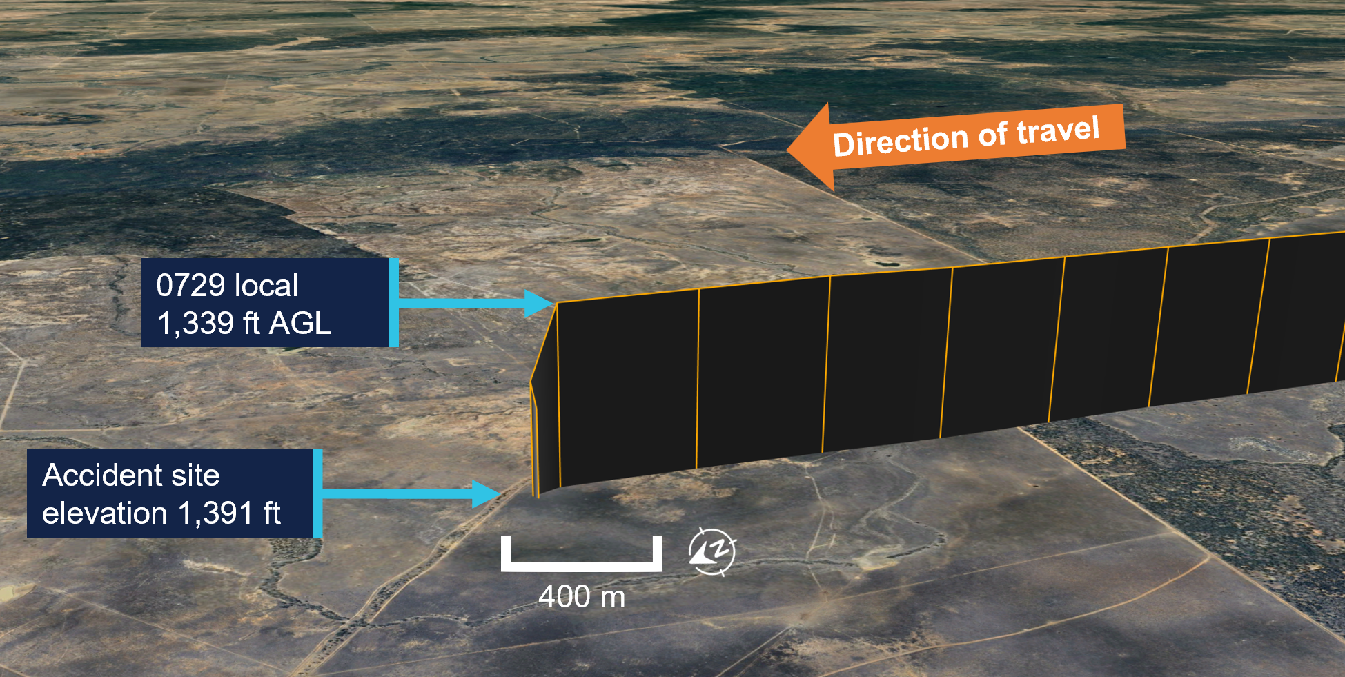
Source: Google Earth, annotated by the ATSB
About 10 minutes later, one of the operator’s staff became concerned that there was no further tracking data for VH‑ESG and contacted another of the operator’s pilots, who was mustering by helicopter on a different property, to advise them. The second pilot immediately ceased mustering operations, landed to refuel, then flew to the last known location of VH-ESG. Arriving at the location at about 0942, the second pilot commenced a search and after a short time located the wreckage of VH‑ESG. The second pilot landed. The pilot of VH-ESG had been fatally injured and the helicopter destroyed.
Context
Pilot information
The pilot held a Civil Aviation Safety Regulations 1998 Part 61 Commercial Pilot Licence (Helicopter), first issued in August 2016. The pilot was issued with a class 1 and 2 aviation medical certificate in January 2026, and at this time reported they had accrued about 5,600 flying hours.
Helicopter information
VH-ESG was a Robinson R22 Beta powered by a 4-cylinder, horizontally opposed, Lycoming O‑360‑J2A engine, which was fan cooled. The helicopter was manufactured in 2007 and first registered in Australia on 19 May 2015. The helicopter had been registered to the operator since 20 January 2017.
The last periodic inspection was carried out in February 2026 and at that time the helicopter had accumulated 5,000.2 hours total time in service.
Meteorological information
There were no official weather observations available near the accident location. The nearest official weather observations were obtained from Blackall Airport located 108 km to the south-west, with forecasts obtained for Emerald Airport, 193 km east-north-east, and Longreach Airport, 216 km west‑north‑west.
The aerodrome forecast (TAF)1 for Emerald Airport issued at 0327 local included a TEMPO2 for broken cloud at 1,300 ft above the airport (elevation 624 ft) between 0400 and 0800 local time with a south‑east (120°) wind around 5 kt. The TAF issued at 0513 local for Longreach Airport indicated conditions were CAVOK3 with a south‑east (140°) wind around 9 kt.
The graphical area forecast (GAF)4 issued at 0216 local for southern Queensland, and valid at the time of departure around 0643, indicated isolated fog until 0800 and areas of low cloud. The GAF also showed that conditions to the west of the helicopter’s track were forecast to be clear. This was consistent with satellite imagery5 which, according to Bureau of Meteorology analysis, showed the development of low‑level cloud and fog signatures in the vicinity of the accident from approximately 0500.
On the morning of the accident, other pilots flying from the operator’s base in Tambo reported a distinct inversion layer6 at about 400 ft AGL. They reported the outside air temperature being cold below the inversion layer and warm and humid above it. There was no visible moisture. A further 100 ft above that, there was reportedly another distinct inversion layer where bushfire smoke could be smelt.
A person on the ground about 7 km from the accident site on a ridge line reported there were patchy clouds in the area and there was no rain or fog.
Site and wreckage information
The accident site was located in flat, open farmland. Topographical data showed the accident site elevation was about 424 m above sea level (1,391 ft AMSL). The main wreckage included the cabin, engine, mast, and main rotor assembly (Figure 2).
Figure 2: VH-ESG main wreckage
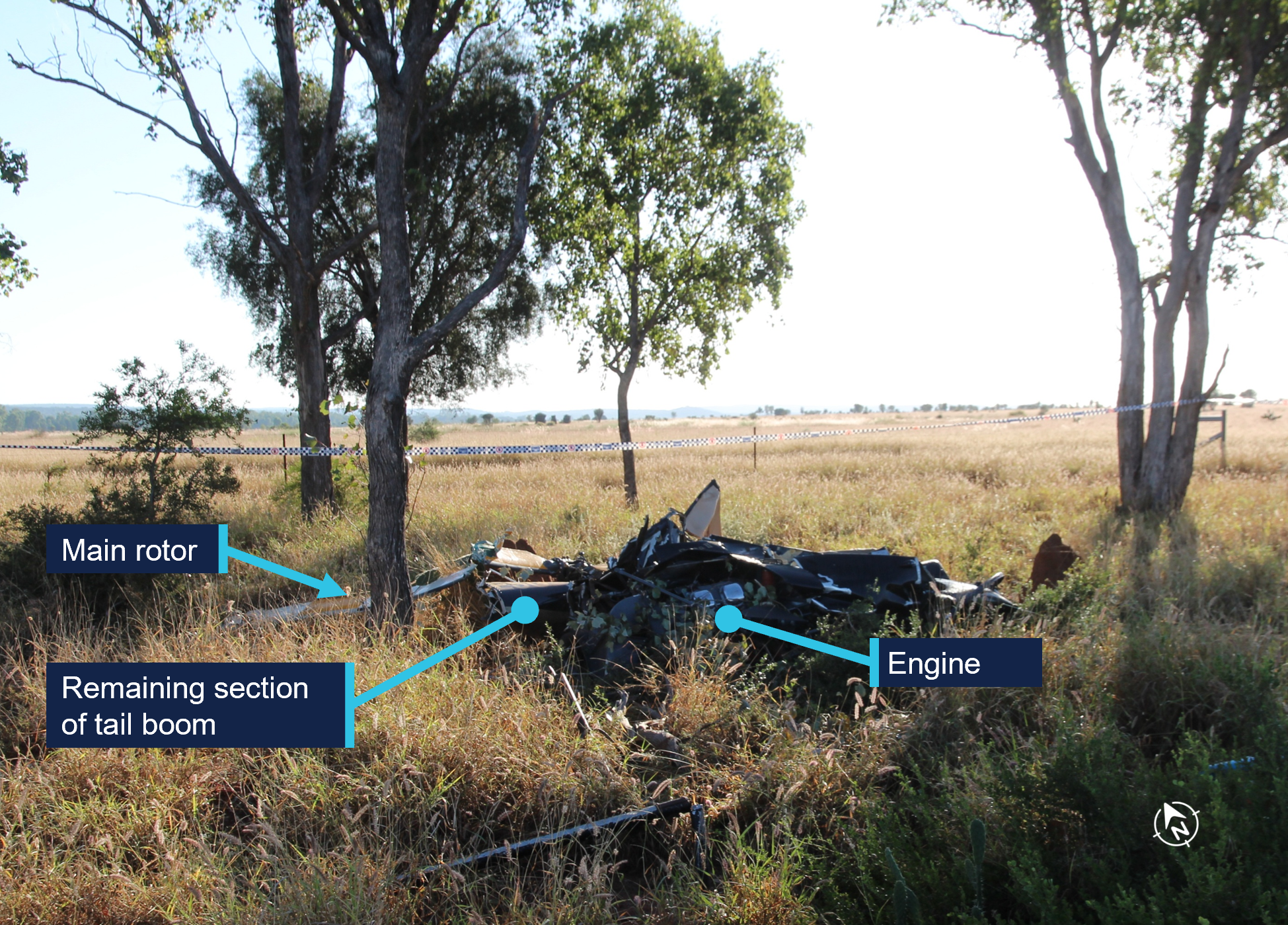
Source: ATSB
Both fuel tanks had ruptured due to impact forces. However, there was no fire.
Damage to the main rotor blades, tail boom, and other components indicated that the main rotor had impacted the tail boom in flight (Figure 3).
Figure 3: Tail boom fragment showing main rotor strike mark
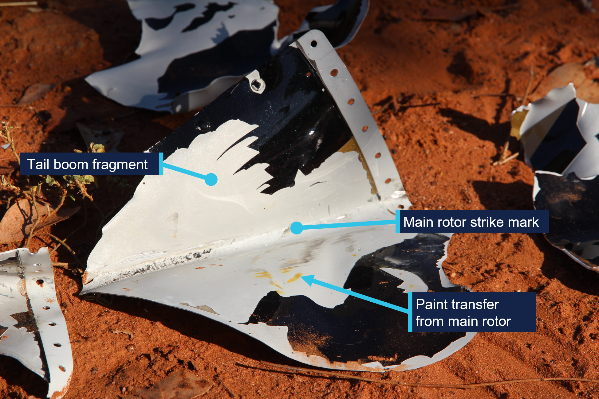
Source: ATSB
Fragments of the tail boom were spread throughout a debris field that extended up to 400 m south of the main wreckage. The tail rotor and gearbox assembly was located about 250 m away from the main wreckage and sections of the tail rotor drive shaft were located throughout the debris field. This spread of debris, along with evidence of the main rotor striking the tail boom in flight, indicates that there was an in‑flight break‑up.
The impact damage limited the extent to which any pre-impact defects could be identified, however from the evidence available, no engine, flight control or structural issues were identified.
Recorded data
The helicopter was fitted with a TracPlus unit that transmitted the helicopter’s location, altitude, and groundspeed via satellite or a mobile phone network every 15 seconds. This information was monitored by the operator for search and rescue purposes.
The helicopter was also fitted with a Garmin aera 660 GPS which was retained for further examination.
Further investigation
To date, the ATSB has examined the accident site and wreckage, interviewed witnesses, collected meteorological data, aircraft maintenance and pilot records, and obtained flight tracking data.
The investigation is continuing and will include further review of:
- pilot records and medical information
- aircraft maintenance and flight records
- recovered components
- witness information
- meteorological data
- recorded aircraft tracking data.
Should a critical safety issue be identified during the course of the investigation, the ATSB will immediately notify relevant parties so appropriate and timely safety action can be taken. A final report will be released at the conclusion of the investigation.
Acknowledgements
The ATSB gratefully acknowledges the support provided by the property owner to the investigation team.
Purpose of safety investigationsThe objective of a safety investigation is to enhance transport safety. This is done through:
It is not a function of the ATSB to apportion blame or provide a means for determining liability. At the same time, an investigation report must include factual material of sufficient weight to support the analysis and findings. At all times the ATSB endeavours to balance the use of material that could imply adverse comment with the need to properly explain what happened, and why, in a fair and unbiased manner. The ATSB does not investigate for the purpose of taking administrative, regulatory or criminal action. About ATSB reportsATSB investigation reports are organised with regard to international standards or instruments, as applicable, and with ATSB procedures and guidelines. Reports must include factual material of sufficient weight to support the analysis and findings. At all times the ATSB endeavours to balance the use of material that could imply adverse comment with the need to properly explain what happened, and why, in a fair and unbiased manner. An explanation of terminology used in ATSB investigation reports is available here. This includes terms such as occurrence, contributing factor, other factor that increased risk, and safety issue. Publishing informationReleased in accordance with section 25 of the Transport Safety Investigation Act 2003 Published by: Australian Transport Safety Bureau © Commonwealth of Australia 2026 
Ownership of intellectual property rights in this publication Unless otherwise noted, copyright (and any other intellectual property rights, if any) in this report publication is owned by the Commonwealth of Australia. Creative Commons licence With the exception of the Commonwealth Coat of Arms, ATSB logo, and photos and graphics in which a third party holds copyright, this report is licensed under a Creative Commons Attribution 4.0 International licence. The CC BY 4.0 licence enables you to distribute, remix, adapt, and build upon our material in any medium or format, so long as attribution is given to the Australian Transport Safety Bureau. Copyright in material obtained from other agencies, private individuals or organisations, belongs to those agencies, individuals or organisations. Where you wish to use their material, you will need to contact them directly. |
- ^ TAF (aerodrome forecast): a statement of meteorological conditions expected for the specified period of time in the airspace within 5 NM (9 km) of the aerodrome reference point.
- ^ TEMPO: A temporary deterioration in the forecast weather conditions, during which significant variation in prevailing conditions are expected to last for periods of between 30 and 60 minutes
- ^ Ceiling and visibility okay (CAVOK): Visibility, cloud and present weather are better than prescribed conditions. For an aerodrome weather report, those conditions are visibility 10 km or more, no significant cloud below 5,000 ft, no cumulonimbus cloud, and no other significant weather.
- ^ GAF (graphical area forecast): provides information on weather, cloud, visibility, icing, turbulence and freezing level in a graphical layout with supporting text.
- ^ Himawari‑9 Night Microphysics satellite imagery provided by the Bureau of Meteorology.
- ^ An inversion layer is where the temperature increases with height, rather than decreasing as is normal. A low-level or surface inversion occurs when the ground cools overnight by radiating heat, also cooling the layer of air closest to the ground. These low-level inversions form a stable layer of air, typically extending a few hundred feet and prevent the higher altitude wind from mixing with the lower-level winds near the ground.
Occurrence summary
| Investigation number | AO-2026-073 |
|---|---|
| Occurrence date | 20/04/2026 |
| Occurrence time and timezone | 09:11 Australian Eastern Standard Time |
| Location | 42 km south-east of Jericho |
| State | Queensland |
| Report release date | 11/06/2026 |
| Report status | Preliminary |
| Anticipated completion | Q3 2026 |
| Investigation level | Short |
| Investigation type | Occurrence Investigation |
| Investigation phase | Examination and analysis |
| Investigation status | Active |
| Mode of transport | Aviation |
| Aviation occurrence category | In-flight break-up |
| Occurrence class | Accident |
| Highest injury level | Fatal |
Aircraft details
| Manufacturer | Robinson Helicopter Co |
|---|---|
| Model | R22 Beta |
| Registration | VH-ESG |
| Serial number | 4120 |
| Aircraft operator | B & T Philp Pty Ltd |
| Sector | Helicopter |
| Operation type | Part 91 General operating and flight rules |
| Activity | General aviation / Recreational-Other general aviation flying-Ferry flights |
| Departure point | Tambo, Queensland |
| Destination | Lambton Meadows, Queensland |
| Injuries | Crew - 1 (fatal) |
| Damage | Destroyed |